|
Home | Blog Index | Blog Archives | Christianity & Faith Essays | Storm Chasing Essays
Storm chasing forecast update for April 22
Another quick update to post about a possible chase to the Great Plains on Friday the 24th. This setup in eastern Kansas is not a slam dunk by any means, but it's looking to satisfy my criteria for two reasons - one, it's a relatively short drive from St. Louis, and two, there is no apparent simultaneous tornadic supercell environment affecting the STL region.
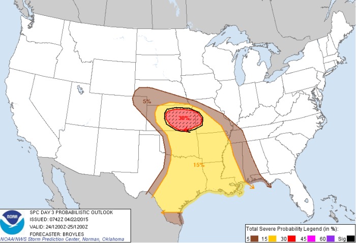
Friday's setup features a broad swath of 50knot-plus midlevel southwesterly winds overspreading the southern Plains. At the surface, a plume of moisture should lift into central/eastern Kansas and be in place by storm time along the dryline/triple point on Friday afternoon. Right now, the only issue I see with this setup is that the midlevel jet seems focused a little too far south and east, with models showing 30-40knots of flow barely grazing the triple point/warm front in central Kansas.
The other issue with this day, of course, is traffic. A Friday afternoon event in the vicinity of Wichita/Salina/Kansas City has the potential to be packed with storm chasers. I'm hoping a robust secondary target along the warm front takes shape north of I-70, in which case I'll forego the dryline/triple point.
The nice thing for me (and any chaser who lives near STL) about this day is that it's close enough to make it a "day trip", departing in the morning and arriving back home sometime after midnight. This means I can scratch the chase if morning data shows either high bust potential or supercells in the Midwest. Beyond this weekend, there is no clear signal on what to expect for the remainder of the month into the beginning of May. What I can see doesn't look like any big events are on the horizon, but that could change. storm chasers are just going to have to take it week-to-week.
The following table charts the probability of a Great Plains storm chase expedition happening for several indicated date ranges in the near future:
| 2015 Plains Storm Expeditions - Probabilities as of April 22 |
| April 24 | 70% | |
| April 25-30 | 10% | |
|
|


