|
Home | Blog Index | Blog Archives | Christianity & Faith Essays | Storm Chasing Essays
Storm chasing forecast update for May 3
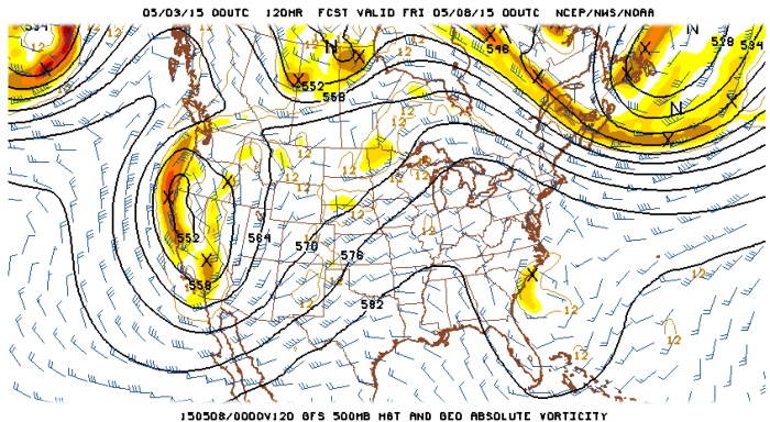
We're now getting into the heart of the spring Great Plains tornado season. While there aren't any big outbreaks indicated on the horizon, I think the conditions will be favorable for a few isolated tornadic supercell events here and there over the Plains. A general western troughing pattern, southwesterly flow aloft and deep moisture should all be in place over the Plains toward the end of the week. Here's the 500mb pattern shown for Thursday:

The main drawback I can see with this upcoming pattern is weaker-than-usual capping. That could mean too many storms firing too early. Even so, it looks like we'll see a string of multiple 5% tornado risk type days (on SPC outlooks). Despite the lack of a moderate/high risk type outbreak being evident, a pattern like this can indeed produce some great events. You don't need an outbreak or maxed-out parameters to have a good tornado intercept - Bennington and Rozel days in 2013 are examples. And with a trough in place, all that is needed for an 'outbreak' scenario is a little impulse in the flow showing up at the right time.
Since the upcoming setups aren't so clear cut, I will likely not make a decision to chase any of these days until the last minute. However, I'm fairly optimistic that at my first Plains storm chase expedition of the season will probably happen later this week. Stay tuned!
The following table charts the probability of a Great Plains storm chase expedition happening for several indicated date ranges in the near future:
| 2015 Plains Storm Expeditions - Probabilities as of May 3 |
| May 4-6 | 20% | |
| May 7-10 | 70% | |
|
|