|
Home | Blog Index | Blog Archives | Christianity & Faith Essays | Storm Chasing Essays
Plains storm forecast update No. 4: for April 8
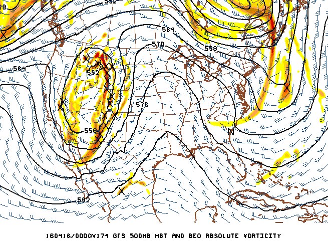
The models haven't really shown much of a change in the upcoming system indicated for late next week. To recap, a decent shortwave trough is shown ejecting during the Friday-Saturday timeframe, spreading strong southwesterly to southerly upper flow over the Great Plains. Models have remained remarkably consistent and in agreement on this general pattern, something you don't see too often in the long ranges.

GFS model 500mb winds forecast for Friday evening, April 15
Unfortunately for storm chasers, what models also have been agreeing on is showing that pesky southern jet max over the northern Gulf of Mexico midweek, followed by offshore flow aloft over the Gulf coast up until the day the trough ejects over the Plains. This is promising to severely curtail northward transport of deep moisture into the Plains ahead of the trough. And indeed, models indicate a very meager "just in time" instability axis to underlay the trough's upper flow on both Friday and Saturday. Right now, southeastern New Mexico on Friday looks like a conditionally interesting "local" play if I lived within a couple of hours of there, but certainly nothing I'd drive for a day and a half to chase. Saturday looks even worse, with a *very* marginal play shown in eastern Kansas under the otherwise nice-looking compact shortwave. For systems like this, as a storm chaser you want to see a strong moisture return from the Gulf in the days leading up to it, not a last-minute-arriving weak moist layer. For these reasons, I'm lowering my confidence in a storm chase expedition for this system being worthwhile.
Looking further out, there aren't really any strong signals for a big Plains event that catch my attention. More shortwaves are shown ejecting out across the Plains and Midwest, any of which could turn out to be an chasable event if moisture can become well-established ahead of them. We'll just have to wait and see what those look like when they get within reasonable forecasting range.
And just to cover all of the bases, there are a couple of potential storm chase days shown for Oklahoma and then the Arklatex region for this Sunday and Monday. While these appear to be several degrees better in quality than next week's system, I haven't been impressed enough with either to really consider a trip. Sunday's play in Oklahoma actually appears quite decent, with sufficient flow overlaying robust instability - and a supercell or two appears likely with that setup. Monday's event is farther south and east in bad chase terrain, and isn't much of a motivating factor. Since I really prefer to get "bang for my buck" with multiple high-end storm chase days in a row, driving the 8-9 plus hours to the storm chaser-congested Oklahoma City area for one day on Sunday isn't that appealing for me. That being said, I won't rule out a last-minute change of mind!
The following table charts the probability of a Great Plains storm chase expedition happening during several indicated date ranges in the near future:
| 2016 Plains Storm Expeditions - Probabilities as of April 8 |
| April 9-12 | 15% | |
| April 13-17 | 15% | |
| April 18-22 | 10% | |
|
|