|
Home | Blog Index | Blog Archives | Christianity & Faith Essays | Storm Chasing Essays
Plains storm forecast update No. 2: for March 21
Just a quick update to talk about the last week or so of March in terms of chasing potential in the Great Plains. As is fairly typical for most of March, we don't yet have any good potential tornado setups announcing themselves on long-range models for the rest of the month.

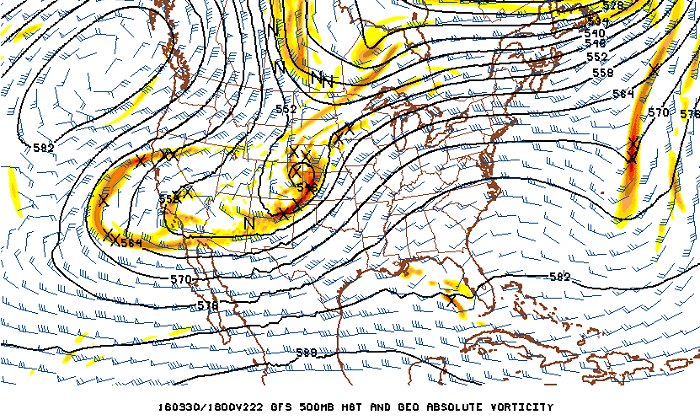
GFS model 500mb winds forecast for March 30
A nice little shortwave trough is shown ejecting across the central Plains sometime during the middle of next week (image above), however, surface moisture has been shown to be very meager for this event. Models have been in agreement on the next few impulses between now and then to push cold fronts into the Gulf of Mexico, keeping good moisture out of reach for next week's system. At best, there should be some photogenic supercells and large hail with next week's system, but nothing that would motivate me to make the season's first drive out west. At this point, it seems very unlikely for a trip-worthy setup to present itself in the Plains this March.
It may be worth noting that the GFS' "fantasy land" forecast for April 1 and beyond shows the dreaded "Hudson Bay vortex" (a deep eastern trouging pattern) becoming firmly entrenched, which will keep the Plains severe weather mechine shut down for the long term. It's better for that to happen this early in the season than in mid to late May!
The Midwest, on the other hand, is still in play for a possible "local" setup or two before the end of the month. One of these might be close enough to St. Louis for me to get in another legitimate March chase.
To summarize, I see little chance of Great Plains trip #1 happening before April 1 - which again, is not out of the ordinary for the average season. April and May are almost here - and we should start seeing some potential action showing up in the mid/long ranges very soon. Stay tuned!
The following table charts the probability of a Great Plains storm chase expedition happening during several indicated date ranges in the near future:
| 2016 Plains Storm Expeditions - Probabilities as of March 21 |
| March 21-25 | 1% | |
| March 26-31 | 2% | |
|
|