|
Home | Blog Index | Blog Archives | Christianity & Faith Essays | Storm Chasing Essays
2016 storm season blog kickoff
It's that time of year again! Another meteorological winter is behind us, and for storm chasers, the open roads of the Midwest and Plains will soon be in our sights as the central USA's peak severe weather season ramps up. Lower gas prices promise to ease the financial burden for travel this season, so mostly, we just need to hope for an equally-cooperative atmosphere.
First forecast look
This early in the season, the biggest tornado risks tend to be in deep south Texas and more conditional than the typical setups in April and beyond. As a result, I rarely plan for Plains trips in March unless a once-every-20-years outbreak like 3/13/1990 becomes evident. The Midwest region, including here at home in St. Louis, however is a different story. I've had at least 2 or 3 legitimate tornado risks each season here locally in March, and I would expect to encounter some of that again this year.
That being said, from March onward I'm always watching the patterns for possible storm setups on long-range models for both the Plains and the Midwest. So what are these sources showing right now? An item of possible interest is a western upper trough shown on both the Euro and GFS models taking shape some time late next week. As I've said many times, past 7 days it gets really dicey in terms of trying to predict storm setups, so this is more of a "mental exercise" to start out the season than a serious forecast. The Euro shows a more favorable orientation to the trough, keeping it deep and dominant, although slightly too far west to really spread optimal southwesterly upper flow over the Plains. The GFS' solution shows a more dominant eastern trough over the Hudson Bay region, while a more compact yet positively-tilted shortwave trough moves across the southern Plains. Again, this is not an optimal orientation for tornadoes.
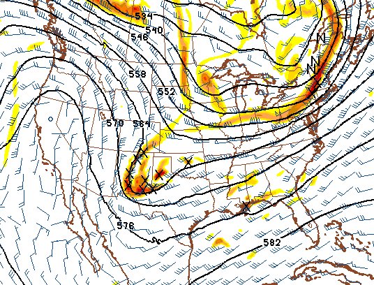
GFS model 500mb winds forecast for March 18
Despite this feature showing on models, I am not expecting it to produce anything chase-worthy (at least for me) at this stage in the game. And so for now, the chances of a Plains trip happening for the near future will stay low.
As with past years, I'll attempt to illustrate my optimism (or lack thereof) for upcoming storm prospects in the Great Plains region. The following table charts the probability of a Great Plains storm chase expedition happening for several indicated date ranges in the near future:
| 2016 Plains Storm Expeditions - Probabilities as of March 9 |
| March 9-14 | 1% | |
| March 15-21 | 5% | |
|
Hope they stay away march 30
- Posted by mom | | |
|


