|
Home | Blog Index | Blog Archives | Christianity & Faith Essays | Storm Chasing Essays
2017 Plains forecast update #10: for June 5: A re-awakening?
I really had this season written off last week. I even went and did my traditional end-of-season car wash to remove all of the Plains rural road dirt and mud. But the models have been sending a consistent signal for the past several days that we might not be done yet! What should appear this weekend into next week on model output but a nice western trough and several days of good midlevel southwest flow over the Plains:
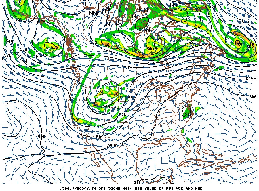
GFS forecast for June 12
All systems have concerns, and this one is no exception. Given the late season, we will have a very strong cap to contend with. This could lead to one or more "cap busts" where no storms are able to develop in an atmosphere otherwise primed for supercells and tornadoes. There have also been some indications that the only areas where storms could form is along a cold front, which would favor either a line or badly undercut storms. Nonetheless, the basic ingredients for supercells and tornadoes will be present in sufficient quantities.
Logistically speaking, an issue of less concern is much of the action could be in the northern Plains, meaning long trips out, back and possibly in between individual storm chase days. This would likely mean extra overnight stays during the trek out and back as well as the cost of such a high-mileage chase in both funds and PTO days. Ending up in the Dakotas usually doubles the cost of a trip for me, and as a result, my "setup criteria" for storm chasing in that region will be more stringent than if this was going to be in Kansas.
All things considered, this system is definitely on my radar for a possible Plains trip #2 for the year, starting this weekend if things work out similar to what the models are showing right now. I'll be watching this closely as this week progresses. There is still a lot of time for this system to crash and burn as it comes into short-range focus, but the models' consistency and agreement on it over the past 3-4 days is encouraging.
The following table charts the probabilities for a Plains storm chase expedition taking place for the date ranges shown:
| 2017 Plains Storm Expeditions - Probabilities as of June 5 |
| June 6-9 | 0% | |
| June 10-14 | 40% | |
|
GO: Home | Storm Chase Logs | Photography | Extreme Weather Library | Stock Footage | Blog
Featured Weather Library Article:
|


