|
Home | Blog Index | Blog Archives | Christianity & Faith Essays | Storm Chasing Essays
Becoming a "storm snob": Plains forecast update for May 7
The phenomenal events of last May have pushed me solidly into a new phase of my photography life, one that many will call that of a "storm snob". Storm snobbery means you go only the best of the best, and sit out the rest. I'm not anxious to get out onto the Plains to chase just anything - I'm waiting for a true quality setup. And I'm fine with the possibility that it won't happen this year!
Living in the Midwest, I get many low-quality, marginal setups to chase year-round, some of which produce. I've seen an EF4 already this year 60 miles southeast of my apartment! If I'm going to drive 8-12 hours from home, use PTO from work and spend money on hotels, it's got to be for something that I can't get here in my backyard. By that I mean a Dodge City, Rozel or a Bennington (1 or 2) caliber event, and I haven't yet seen anything like that in the current medium-to-long ranges of forecast models.
What I see in the models right now are a few marginal Plains days not unlike what I see here at home many times per year. Could those produce something nice? Sure, they certainly could. Campo and days like April 14 in Dimmitt Texas can always happen on low-risk Plains setups. But the reality is, most of the marginal days DON'T produce. To see the marginal-day gems, you have to chase virtually ALL of them. I'm simply OK with missing the Campos and Dimmitts. I don't need to see EVERY tornado that happens anywhere in the world or even in the Plains and Midwest. No chaser sees every tornado, not even the best of storm chasers. It's unrealistic (and insanely expensive) to chase to catch *everything*.
So let's get to the specifics of the forecast. An "omega block" upper pattern is in place across the US right now, with deep troughs in the east and the far west. This means ridging and/or northwest flow over the Plains and Midwest, the "downtime" pattern for severe weather as it keeps moisture from returning north from the Gulf of Mexico. The western jet is shown eventually "cutting off" into a closed circulation which drifts slowly east, opening into a trough again as it moves over the southern Plains:
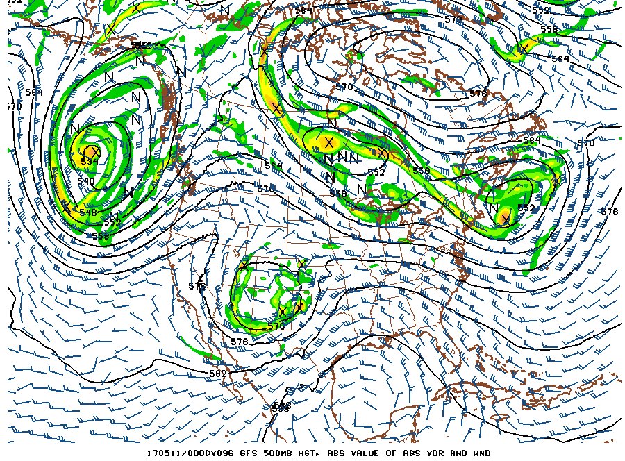
GFS forecast for May 10
These "cutoff lows" are typically bad for storm chasing, as they usually end up with unidirectional wind profiles with lots of clouds and rain. Nonetheless, they can produce one or two low-grade storm chase days as the initial southwest flow aloft promotes some moisture return northward underneath of the stronger midlevel and upper-level winds. That's what is shown now, with Wednesday along the dryline in Kansas, western Oklahoma and the Texas panhandle looking like the best of the mix. Unfortunately, instability just looks to be too low for this to be on my radar for a trip. After that, yet another cold front is shown sweeping the moisture back into the Gulf, and doesn't look like it will return again in meaningful quantities on the dryline for quite some time.
With Wednesday looking like a low-end setup and the pattern following showing no signs of anything chase-worthy, I don't expect a Plains trip to begin within the next 10 days.
The following table charts the probabilities for a Plains storm chase expedition taking place for the date ranges shown:
| 2017 Plains Storm Expeditions - Probabilities as of May 7 |
| May 7-9 | 0% | |
| May 10 | 10% | |
| May 11-16 | 5% | |
|
Here are a couple of logs for recent Midwest chases:
April 29: Severe storms north of St. Louis
I drove up to Madora to stay in front of a circulation embedded in the squall line, staying with it to Farmersville. Nothing of note chased.
April 30: Storms northwest of St. Louis
A marginal environment for supercells presented itself in eastern Missouri this day east of a surface low in eastern Kansas. I drove up to Moscow Mills to take a look at some convection that finally got going in this area, but didn't see anything of interest. I decided not to follow these to the northeast, and headed home early.
May 10: Storms north of St. Louis
An outing from Livingston, IL to St. Charles for storms moving in from the north of St. Louis. No photos or video captured.
GO: Home | Storm Chase Logs | Photography | Extreme Weather Library | Stock Footage | Blog
Featured Weather Library Article:
|


