|
Home | Blog Index | Blog Archives | Christianity & Faith Essays | Storm Chasing Essays
Storm chasing forecast update for April 19
An April when I've been capturing icy road footage and when daily highs have struggled to reach 50F are not the signs of an active tornado season. Despite a brief round of storms on the 3rd and again on the 13th, the weather has resembled February more than April here in the Midwest.
Unfortunately, all of our available model data does not offer any hope that this trend will reverse anytime soon. The GFS and European models are in fair agreement that some sort of cold, detrimental-to-storms pattern will persist over the central United States over the next 2 weeks or so. While a few shortwave troughs are shown traversing the country, all will likely do so overtop of meager-to-non-existent surface moisture. The deep moisture (fuel for storms) will be kept far to the south in the tropics by repeated cold fronts brought on by each passing trough.
Furthermore, a larger multi-day trough is shown parked over the eastern US late next week, which is the opposite of what storm chasers like to see in the spring. These "eastern troughs" bring cold, gloomy weather to the Midwest and Plains, drive cold fronts partly to the tropics and keep the ever-critical moisture far away from the Plains.
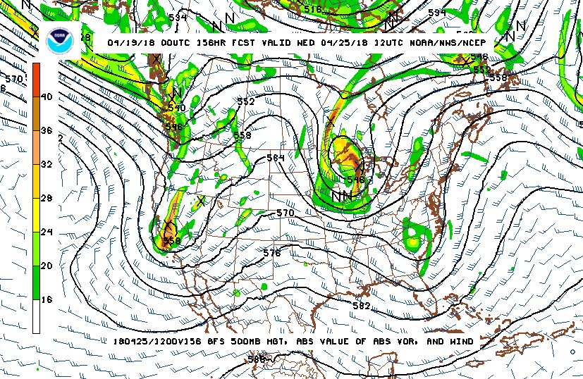
GFS 500mb pattern for April 25
Is this a reason to be concerned for the peak season from mid-May to early June? Not really, at least not yet. The large-scale weather pattern - and the storm chasing season - can turn on a dime. Within as little as a day or two, models could start showing a big western trough at the far end of the medium ranges, one which starts bringing the Gulf moisture northward in abundance. That being said, it appears very likely this April will be one of the bigger duds in storm chasing history, quite below average on all thunderstorm, temperature and severe weather metrics.
I don't see any signal for chaseable tornado environments until at least the end of the month in either the Plains or the Midwest. Accordingly, the probabilities of a Plains storm chase expedition happening during this period will remain very low.
The following table charts the probabilities for a Plains storm chase expedition taking place for the date ranges shown:
| 2018 Plains Storm Expeditions - Probabilities as of April 19 |
| April 19-24 | 1% | |
| April 25-30 | 2% | |
|
GO: Home | Storm Chase Logs | Photography | Extreme Weather Library | Stock Footage | Blog
Featured Weather Library Article:
|


