|
Home | Blog Index | Blog Archives | Christianity & Faith Essays | Storm Chasing Essays
Plains trip forecast update 4, for April 25
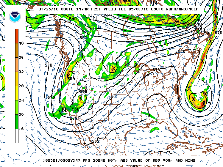
After a long and cold April, May's arrival is bringing with it the first potentially chaseable system in the Great Plains to watch. Medium-range models have been consistent and in general agreement showing a western upper trough traversing the Plains and Midwest regions during the middle of next week.

GFS 500mb pattern for May 1
Models also show deeper moisture streaming north in abundance over the Plains for the first time this season during this period, providing the two basic ingredients storm chasers want to see for supercells and tornadoes: instability and upper-level support.
While it looks like we'll have those basics in place, it is too early to pin down exactly how "quality" this system will be in terms of other important factors: storm mode, cloud cover and cap strength being the biggest things to watch for as this event draws closer. It does appear that this will be a good candidate for the season's first Plains storm chase expedition, so today's chase probability table will reflect that. The chances will increase if some of those finer details become clearer.
Beyond next week's system, were still in that hazy long-range period where model performance is not reliable enough to even guess on the pattern. However, climatology and the prospect of moisture remaining in place is enough to give a slight uptick to storm chase expedition chances following May 4.
The following table charts the probabilities for a Plains storm chase expedition taking place for the date ranges shown:
| 2018 Plains Storm Expeditions - Probabilities as of April 25 |
| April 25-29 | 1% | |
| April 30-May 3 | 40% | |
| May 4-9 | 15% | |
|
| View 1,609 storm chases: |
| by year: |
|
| by type: |
|
|
|
GO: Home | Storm Chase Logs | Photography | Extreme Weather Library | Stock Footage | Blog
Featured Weather Library Article:
|