|
Home | Blog Index | Blog Archives | Christianity & Faith Essays | Storm Chasing Essays
Storm chasing forecast update 8 - for May 26
Plains storm chase expedition #2 for the year took place last Saturday, an out-and-back-in-one-day trip to eastern Kansas for a setup that essentially fizzled during the early morning hours due to too much overnight convection. I will eventually post a proper chase log for that day (along with its quad-dashcam timelapse), but I have been too busy with work and other at-home tasks to have time to sit down and hammer that out.
The abysmal upper level and surface weather patterns characteristic of the 2018 season so far have continued. That being said, there is some High Plains action possible in Colorado and Nebraska starting Sunday as a western upper trough grazes these areas with coveted southwesterly flow, albeit it is shown being on the weak side with intermittent bursts of workable flow of 30 knots and above:
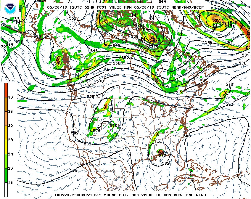
GFS 500mb pattern for May 28
Upper support is one piece of the puzzle for supercells and tornadoes, the other is moisture. And that is the bigger concern with this system. Take a look at what's in the Gulf of Mexico on that chart above. Yes, that's a tropical cyclone - Alberto - that will potentially be a hurricane at landfall. Those are one of the last things a storm chaser wants to see during spring storm season. The main reason these are so bad is because the winds on their western side are northerly, turning the winds in the Great Plains moisture fetch in the *opposite* direction they need to be. This shuts off the conveyor belt of low-level Gulf moisture return into the Plains, leaving only the residual moisture over land as the source for instability needed for thunderstorms. Without a steady supply of fresh Gulf moisture, the low level mositure in the Plains is prone to being shallow and mixing out into drier air above it. Therefore, any potential tornado setup will depend on localized pooling of the residual moisture and any small-scale feature that can boost it and limit its mixing (such as evapotranspiration from green vegetation).
Without the tropical system, it would be a no-brainer to give the Sunday-Wednesday system a go. With Alberto in the mix, it's highly questionable - and so I'm on the fence about a departure for Plains trip #3 to cover it.
Beyond this next system, it appears we'll have some upper-level flow available in the northern Plains late next week. It remains to be seen how the moisture situation will play out for that, but I'm at least watching its potential.
The following table charts the probabilities for a Plains storm chase expedition taking place for the date ranges shown:
| 2018 Plains Storm Expeditions - Probabilities as of May 26 |
| May 26-30 | 50% | |
| May 31-June 7 | 25% | |
|
GO: Home | Storm Chase Logs | Photography | Extreme Weather Library | Stock Footage | Blog
Featured Weather Library Article:
|


