|
Home | Blog Index | Blog Archives | Christianity & Faith Essays | Storm Chasing Essays
Storm chasing forecast update 6, for April 23
If you have followed this chase blog over the years, you shouldn't be surprised at how quickly a medium to long-range outlook can change. You might have noticed how these flip-flops happen especially after making a decisively pessimistic post as I did two days ago. Since the update #5 post, some very encouraging signs have started to show up on multiple data sources for the period beginning May 1, which is now inside of the 10-day window where we can put at least a little stock into medium-range model forecasts. And what is showing up is very nice indeed:

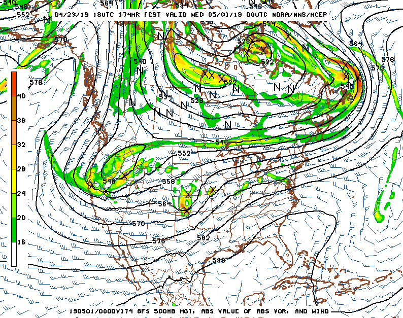
GFS 500mb pattern forecast for April 30
Beginning next Tuesday, April 30, much of the medium-range models show a long-term western trough sitting in place for multiple days spreading strong upper-level southwesterly winds over the Plains, with daily good low-level moisture (well above 60°F dewpoints) underneath of those winds. That would mean it's "go-time" for storm chasing!
Of all the medium-to-long range data sources I use (5 to 10 days out), only the European model isn't completely on board with the pattern. The Euro's opinion isn't one to dismiss, though, so for that reason I'm not 100% gung-ho yet about the pattern working out. That being said, it is enough to increase Plains storm chase expedition probabilities for April 30 and beyond to at least 45% - a number that will increase if models stay consistent and especially if the Euro gets on board.
The following table charts the probabilities for a Plains storm chase expedition taking place for the date ranges shown:
| 2019 Plains Storm Expeditions - Probabilities as of April 23 |
| April 24-29 | 2% | |
| April 30-May 5 | 45% | |
|
| View 1,609 storm chases: |
| by year: |
|
| by type: |
|
|
|
GO: Home | Storm Chase Logs | Photography | Extreme Weather Library | Stock Footage | Blog
Featured Weather Library Article:
|