|
Home | Blog Index | Blog Archives | Christianity & Faith Essays | Storm Chasing Essays
Storm chasing forecast update 9, for May 11
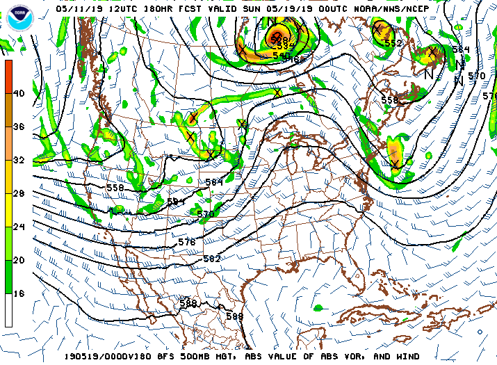
Over the past 48 hours, multiple models have started to indicate - with consistency - a chasing-favorable pattern beginning around next weekend, and continuing long-term. What some of the runs have been trending toward is a pattern for multiple-day supercell and tornado events like we haven't seen in many seasons in the Plains: a long-term southwesterly jet aloft with multiple "shortwaves" of energy ejecting (each of which can produce enhanced tornado potential) and with good low-level moisture remaining in place for the duration of the pattern.

GFS 500mb pattern forecast for May 18
Even a muted version of this pattern would likely produce one or two trip-worthy events. For this reason, my confidence in a chase beginning sometime after Friday is unusually high for a system nearly a week out. Higher probabilities are precluded by the fact that there is still time for a catastrophic reversal in model forecasts. If, however, the models are correct about the long-term nature of this pattern, the result would be a unusually-lengthy chase akin to the ones I embarked on in 2004 and 2005, with possibly 5 or more big storm chase days in the mix.
To summarize: a severe weather-favorable pattern in the Great Plains looks to get into high gear soon and possibly stay that way for much of the last half of May!
The following table charts the probabilities for a Plains storm chase expedition taking place for the date ranges shown:
| 2019 Plains Storm Expeditions - Probabilities as of May 11 |
| May 12-16 | 5% | |
| May 17-24 | 75% | |
|
| View 1,609 storm chases: |
| by year: |
|
| by type: |
|
|
|
GO: Home | Storm Chase Logs | Photography | Extreme Weather Library | Stock Footage | Blog
Featured Weather Library Article:
|