|
Home | Blog Index | Blog Archives | Christianity & Faith Essays | Storm Chasing Essays
Storm chasing forecast update 10, for May 14
Models continue to show the prolific and long-term severe weather-favorable pattern beginning in the Great Plains this Friday and continuing for as far out as models can be reasonably trusted. This is a system with the main "ingredients" in place that as a storm chaser, you simply go out and see what each day will bring. The SPC's recent 4 to 8 day outlook summarizes the trend in models so far, with daily events through the end of their forecast period:
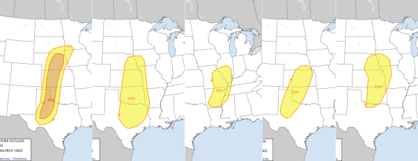
SPC outlooks for Friday-Tuesday
As with most chasing setups, each day is dependent on storm activity the day before, as well as subtle daily changes in the upper-level and surface patterns that models can't really see. Targets for each day will usually need to be determined mostly the morning of by analyzing surface data and visible satellite imagery. For that reason, there's not much of an itinerary for this trip aside for the first day (Friday) which appears will be a dryline play in either central/western Kansas and/or Oklahoma.
I'm making some final vehicle equipment adjustments this week in preparation for what could be a long chase (in excess of a week). With that, it's time to go "green" on the blog indicator with a trip departure on Thursday afternoon!
The following table charts the probabilities for a Plains storm chase expedition taking place for the date ranges shown:
| 2019 Plains Storm Expeditions - Probabilities as of May 14 |
| May 14-16 | 5% | |
| May 17-24 | 99% | |
| May 25-31 | 60% | |
|
GO: Home | Storm Chase Logs | Photography | Extreme Weather Library | Stock Footage | Blog
Featured Weather Library Article:
|


