|
Home | Blog Index | Blog Archives | Christianity & Faith Essays | Storm Chasing Essays
Storm chasing forecast update 8, for May 4
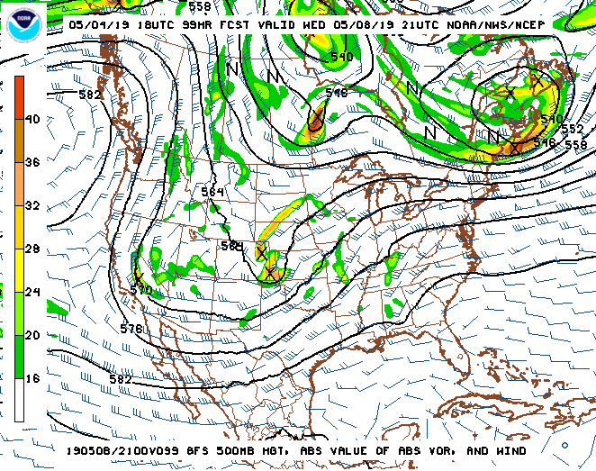
We finally have what we've been waiting for in the storm chasing world, albeit briefly: multiple days of strong upper-level winds over deep moisture in the Great Plains thanks to a western upper-level trough. The biggest day of this sequence appears to be Wednesday the 8th, when a shortwave ejects out over the southern Plains:

GFS 500mb pattern forecast for May 8
While this system has some caveats, as many do (like a looming cold front and the prospect of early-day convection), it nonetheless meets my criteria for a storm chase expedition as it's currently shown. For the first time this season, I'm out of the "red zone" on storm chase expedition probabilities. The tentative plan is for a departure on Monday the 6th for two days of Plains chasing, followed by a Midwestern setup back near home on the 9th.
As this system departs, a cold front should push to the Gulf on Friday, resetting the moisture regime. After that, models have been having trouble locking in on what pattern will follow. Indications have ranged from a deep central US trough (meaning eastern US severe weather) to a southern-stream jet similar to what we saw in April (which would indicate southern Texas/Dixie severe storms). It's simply too soon to have much of an idea on what to expect during this period until the models can settle down. At any rate, the Plains moisture fetch will likely need a few days to recover, consequently, it's unlikely that a Plains trip will continue into or begin during the May 10-15 period.
The following table charts the probabilities for a Plains storm chase expedition taking place for the date ranges shown:
| 2019 Plains Storm Expeditions - Probabilities as of May 4 |
| May 6-9 | 70% | |
| May 10-15 | 20% | |
|
| View 1,609 storm chases: |
| by year: |
|
| by type: |
|
|
|
GO: Home | Storm Chase Logs | Photography | Extreme Weather Library | Stock Footage | Blog
Featured Weather Library Article:
|