|
Home | Blog Index | Blog Archives | Christianity & Faith Essays | Storm Chasing Essays
2020 storm season blog kickoff
It's that time of year again! Another winter is fading, and our cold landscape will soon be overtaken with the welcome green and warmth of spring and summer. Above that, the lightning displays and tornadoes of the storm season are on the doorstep. As with years' past, this season's storm season blog will continue the tradition of logging storm chase days along with forecast excercises about upcoming weather patterns. I'm glad you're here to join me once again for the journey in 2020.
Planned operations this year should, Lord willing, be normal: one or more trips to the Great Plains as tornado-favorable weather systems move through, as well as coverage of severe storms and tornadoes locally here in the lower Midwest.
One wildcard storm chasers are watching in spring 2020 is the coronavirus outbreak, which will likely be spreading across the country during our severe weather season. It remains to be seen how that will impact operations/travel. Current thinking is that storm chasing in the USA should proceed as normal, with likely some extra precautions needed at gas pumps, hotels and other transmission vectors encountered on the road. Stay tuned, as I'll be talking about this more as the situation develops.
Now, let's take our first look at upcoming weather patterns for the first weeks of meteorological spring.
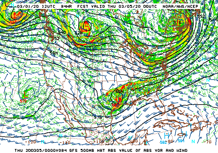
GFS 500mb pattern forecast for March 4
Right off the bat, we have a system moving through the southern third of the country, which will bring storms - some severe - to parts of the lower Midwest and South from Sunday through Wednesday as mostly-meager Gulf moisture is drawn north in advance of this upper wave. While this wave is certainly not long-distance chase-worthy, there is a good chance it will bring some thunderstorms as far north as St. Louis tonight (Sunday). This promises to be enough to get me out locally on the season's first lightning chase.
Beyond midweek, a split-flow jet stream pattern looks to dominate the continental USA for the following 10 days or so, with the southern stream far enough south to effectively barricade deeper Gulf moisture from returning northward. Aside from the aforementioned storm chances in the Deep South, the first part of March 2020 looks to be very quiet as models show now. As a result, chances for a Plains storm chase expedition will start off very low, something that is quite typical for March, as you problably know if you've followed this blog for very long. April is typically the time we'll start seeing some real signs of life out there, though history tells us to always be on the lookout for a March surprise.
The following table charts the probabilities for a Plains storm chase expedition taking place for the date ranges shown:
| 2020 Plains Storm Expeditions - Probabilities as of March 1 |
| March 1-7 | 0% | |
| March 8-14 | 0% | |
|
GO: Home | Storm Chase Logs | Photography | Extreme Weather Library | Stock Footage | Blog
Featured Weather Library Article:
|


