|
Home | Blog Index | Blog Archives | Christianity & Faith Essays | Storm Chasing Essays
Storm season 2020 update 2
The arrival of "official" spring is normally a time of great anticipation and excitement in the storm chasing world as April rises on the horizon. You've seen it every spring here on this blog. But this year will be different than any storm season in the history of our activity that began with David Hoadley in the 1950s. Uncertainty and apprehension has swept the ranks of storm chasers worldwide as we come to terms with a season that will likely be lost. As the shelter-in-place orders and business shutdowns continue progressing across the country, it is looking like most storm chasers - even those that live in the Great Plains and Midwest - may need to sit everything out. We're not alone - lovers of sports, entertainment, music, travel, beaches and more are all having to give up their passions in 2020. But the prospects of a tornado season on the sidelines are the least of our fears. Like the rest of the world, we're bracing for what the pandemic will bring to our jobs, our daily lives, and most importantly our families and our friends.
The coronavirus situation changes rapidly, and may be completely different even in the next 24 hours. Current indications are that storm chasers will, at best, be confined to our home areas, with operations more like local storm spotting than chasing. Here in the St. Louis metro area, the entire region is under a "shelter in place" order that prohibits all non-essential travel and business. Fortunately, the order includes "outdoor recreation" (provided strict social distancing is chased) in its list of allowed activities - so for the time being, the act of going out on a rural road to watch and photograph a storm appears to still be in play. Longer trips bring with them all sorts of risks: availability of services (hotels, vehicle repair, food), risk of virus transmission, the prospect of stricter lockdowns at any time, etc.
What does all this mean for the planned storm chasing operations this year? For one, any Great Plains trips are obviously completely off the table now. All indications are I'll be limited to the immediate St. Louis area. But stricter lockdown orders could come at any time. We simply don't yet know how bad this will get. Conversely, hydrochloroquine could bring a swift end to the crisis, an outcome we are all earnestly hoping for. To put it this way, there is no real plan at this point. Storm chasers are just going to have to take things day-by-day and accept whatever limitations the virus deals us.
As for this blog, I will continue the forecast updates as I normally would. Just as an "exercise", I'll also continue the storm chase expedition probability tables for the chances of a hypothetical - not actual - chase. So, lets move on from the pandemic talk and into the weather patterns.
Forecast update for Sunday, March 22
The next 7 days will be an active period as multiple upper-level troughs (both large and small) traverse the southern half of the country. With active northward moisture transport from the Gulf of Mexico underneath this flow, nearly every day features at least some elevated risk of severe storms from the Plains through the Midwest and South. The GFS and Euro are not in good agreement on the timing and placement of these waves, resulting in high variability on potential risk zones. The GFS moves a compact, well-developed shortwave trough east through the Plains on Monday and the Midwest Tuesday, with supercell threats in each respectively. The Euro brings a weaker and less organized wave through a day earlier, with only lingering flow behind it bringing some supercell risk to the Plains on Tuesday. Both models show a larger wave trailing the first which could bring another moderate event somewhere in the same regions by late in the week.
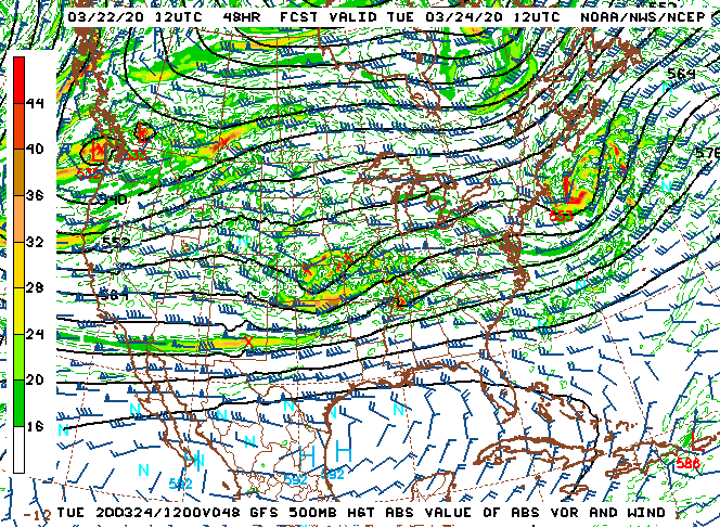
GFS 500mb pattern forecast for March 24
Based on the lack of good agreement in the models for Monday and Tuesday's system and the meager-ness that it appears to be in terms of tornado potential, the chances of a Plains trip for next week would have been low - but not zero.
*The following table outlines the chances for a hypothetical storm chase expedition to take place during the dates shown:
| 2020 Plains Storm Expeditions* - Probabilities as of March 22 |
| March 23-26 | 5% | |
| March 27-31 | 10% | |
|
GO: Home | Storm Chase Logs | Photography | Extreme Weather Library | Stock Footage | Blog
Featured Weather Library Article:
|


