|
Home | Blog Index | Blog Archives | Christianity & Faith Essays | Storm Chasing Essays
Storm chasing season forecast update 4 for March 31
Sunday and Monday continue to have supercell/tornado potential in the Great Plains, but we will also have arguably equal or even better chances of the same here in the Midwest. For that reason, I'm not anticipating a Plains expedition for this system unless some drastic last-minute changes occur in model forecasts.
Now on to the more interesting situation. The next system of note is shown moving into the Great Plains and Midwest toward the end of next weekend. All of the medium-range models including the Euro, the GFS and the GEFS ensemble are showing this general pattern. The following is the GEFS ensemble spaghetti plot showing the jet axis from each ensemble member:
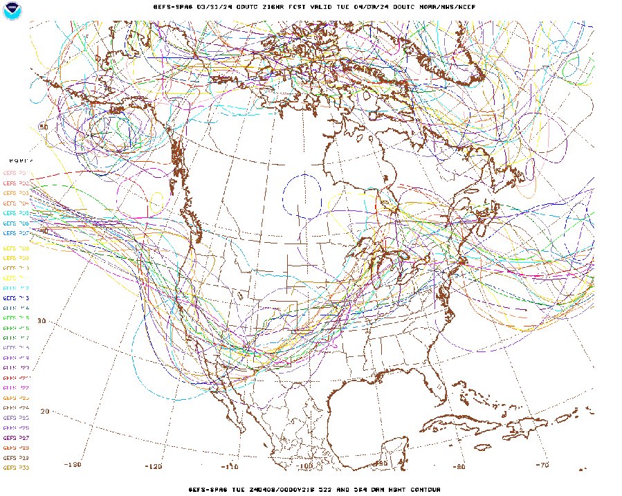
GEFS 500mb ensemble forecast for April 8
The first potential tornado/supercell day with this system portrayed by models is on Monday, April 8, with the risk area shown along a dryline somewhere from Oklahoma down through Texas. What else is happening that day? Yes, the eclipse! So what does this mean? I have absolutely no idea yet!
My priority for Monday is the eclipse, even if there is severe weather forecast for that day. The position/evolution of the upper trough coming in and individual waves/perturbations within it will be impossible to forecast very far in advance, and the cloud situation will very much depend on those. With a western trough moving into the Plains in the spring, that means northward moisture transport from the Gulf of Mexico. Moisture is great for storms, but bad for clear skies.
The ideal scenario for Monday would be a dryline setting up somewhere east of I-35 in Texas. Skies are more likely to be clear west of the dryline. If it would be possible to get west of the dryline for the eclipse, then back east of it for the storms later that evening, that obviously would be great for chasers who want to cover both things. But post-eclipse traffic will very likely make chasing storms afterward in that general area difficult if not impossible.
All of that means that it's entirely possible for my first Plains storm chasing expedition this year to be in Texas next Monday, mainly so I can be west of the dryline for the eclipse beforehand. It's also possible that I'll be in Ohio or New York if the Gulf moisture clouds out everything in the Plains and Midwest. This will be a nail-biter of a week ahead as we watch this system come in and see how models converge on the pattern. Right now, I'd say there is at least a 30% chance of being in Texas (the extreme southern Plains) next Monday. Stay tuned!
The following table charts the probabilities for a Plains storm chase expedition taking place for the date ranges shown:
| 2024 Plains Chase Expeditions - Probabilities as of March 31 |
| March 31-April 1 | 5% | |
| April 2-6 | 1% | |
| April 7-10 | 30% | |
|
GO: Home | Storm Chase Logs | Photography | Extreme Weather Library | Stock Footage | Blog
Featured Weather Library Article:
|


