
|
||||||||||||||||||||||||
EXPEDITION VIDEO: Tower lightning barrage in Lexington, Kentucky: Watch Video LEXINGTON, KY - (photos below) A deadly outbreak of severe storms and tornadoes struck the south-central USA on Tuesday. I had decided early on that the highest risk area of this potential outbreak (Arkansas and western Tennessee) was going to be too far outside of my 'off-season' intercept range. However, with parameters for severe storms and tornadoes reaching well into Kentucky - which is within my range - I decided to head west on Tuesday afternoon to see what I could get. I didn't expect to see tornadoes, but I figured that some interesting severe weather prospects were good enough to make the trip. My initial plan was to head to Louisville and wait for the eventual squall line to reach the metro area. I made it to the Louisville metro around 4PM and stopped for internet to check data, and decided to head farther west into Indiana to get in front of some newly developed storms in far western Tennessee. The storms in the Memphis area began to go supercellular and tornadic rapidly as they rocketed off to the north-northeast. By this time I was past Corydon, Indiana, and decided to continue even farther west to Evansville, in order to drop south on Highway 41 to intercept the tornadic cells as they moved into Kentucky. That's a lot farther than I originally intented to go, but when you're within range of storms like these it's hard to resist it. It would be after dark when I'd meet the cells, but there was going to be plenty of lightning to help illuminate storm features. I caught the first tornado-warned supercell just north of Hopkinsville, Kentucky and positioned myself in front of the radar-indicated circulation so that it would pass just to my west. I had a fairly good visual on the storm's base in the lightning flashes, but did not see any lowerings or tornado-like features. However, my video camera caught what was likely a tornado in progress that I did not notice at the time:

As the circulation passed to my west, I saw a few power flashes embedded in the rain. Below are radar images at the time of intercept, showing the strong velocity couplet associated with the tornadic circulation:
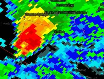 Base reflectivity Base reflectivity
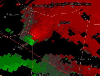 Velocity couplet Velocity coupletThis map shows my location at the time of intercept, along with the direction the camera was pointing at the time of the above images:
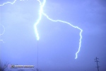
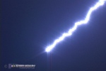
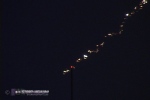
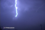
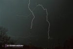
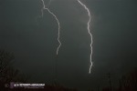
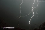
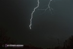
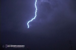
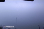
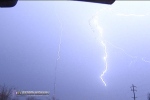
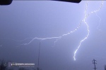
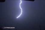
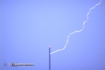
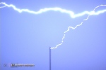
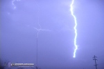
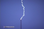
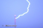
 I headed to Clarksville, Tennessee to get in front of the next supercell in the line, arriving as the tornado sirens were activated. However, convection upstream of the inflow region of the storm was weakening it, and it was nothing more than a lightning and rain-maker when it finally reached me. I contemplated trying for the storms approaching the Nashville area, but with the late hour, the weakening trends and having 5-hour plus drives to get home, I decided against it. I started the return trip around 10:30PM. I had a bear of a drive to get home, since my path took me through the monster squall line that was now moving across the entire mid-Mississippi Valley. The squall line beat me to the Western Kentucky Parkway, and due to its motion parallel to the road and 70-80mph forward speed, I was stuck in the cores of heaviest rain for more than three hours, all the way to Louisville. It was one of the worst drives I've ever had to do. 45-50mph was the top safe speed I could go, as I was hydroplaning constantly and visibility was near zero. On radar, an exceptionally large trailing stratiform precip shield extended nearly 200 miles behind the squall line, and it was heavily electrified. For me this meant one thing - time to go shoot tower lightning! Rather than go straight home, I decided to divert up I-65 to Louisville to set up at the tower farm on the northwest side of the city, on the Indiana side. However, as I got to Louisville, the electrified portion of the precip shield moved off to the north, and there was not much lightning left over the metro. I didn't even get to downtown, instead taking the Gene Snyder beltline to get to I-64 to head home. As I approached Lexington, a more electrified region of the precip shield was heading toward town. I knew about two big TV towers (for CBS affiliate WKYT and ABC affiliate WTVQ) on the east side of town, along Route 60 near the I-64/I-75 interchange. They are not exceptionally tall towers (under 1000 feet AGL) so I had questioned whether or not they would be tall enough for good upward lightning initiation. But with such a huge electrified stratiform shield moving over, I decided to give it a try anyway. As I set the cameras up, the towers were hit the first time - confirming that they would indeed be tall enough to do it! Ten more discharges happened after I got the cameras rolling, a total of eleven hits in about 20 minutes. I had enough time to get two video cameras and my 35mm Pentax set up before the show was over. Here are the results from Lexington (video here):
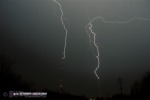 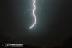 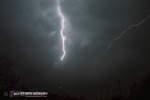 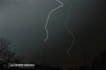
The above photos were shot on Kodak 200 speed print film on a Pentax K1000 SLR, at F8 with a 28mm wide-angle lens. Exposure times ranged from 45 to 120 seconds. The following are frames extracted from video footage shot on two different cameras.
After a Waffle House Breakfast in Mount Sterling, I got home just before 9AM - wrapping up the 1000-mile plus, 19-hour trip.
I'm a stormchaser(lightning-photographer) in southwest coast of Sweden and we have a 1000 foot tall Television tower on a hilly terrain in the southestern part of the city.I really hope on better chances to shoot tower lightning this summer-season because we had near zero lightning over the city last summer,usually we got 7-10 days with thunderstorms each year.In contrast we allready got two days in January -08 wich is a bit rare, I think it partly depends on the really unseasonally mild winter.I have plans to take a chasetrip to Tornado Alley some upcoming year and maybe can meet up with your team :).
I�m a member of a forum called blixtar (lightning in english) sorry,text is in swedish on the site
Here�s a link to me:
https://www.blixtar.se/user.php?id.847 | - Posted by Daniel Carlsson from Gothenburg Sweden Hey, You were Just Minutes form my house when you got on the Gene Snyder. I always think it would be cool to see a Tornado, thats why I want to be a Storm Chaser. I imagine what it was like in 1974. Here is a link to our church website. If you are ever in the area stop in. Small Church but real nice folks. | - Posted by Joshua from Louisville I forgot To put The web adress. www.heritagebaptistlouisvilleky.org | - Posted by Joshua from Louisville Thanks for the comments Joshua and Daniel! Historically Kentucky has been a hotspot for tornadoes in early spring and fall, with April 3-4, 1974 being the classic example of that. I have started paying a lot more attention to this area as a viable target in recent years. It's a lot closer to home! | - Posted by Dan from Charleston, WV I am in Jonesboro Arkansas, and luckily there hasnt been a tornado hit here for awhile, but the towns all around us seem to attract tornados like flies to honey! I'm not brave enough to storm chase, but many thanks to you and your kind who do so to help us learn more about them! | - Posted by Sarah Porter from Jonesboro, Arkansas |
|||||||||||||||||||


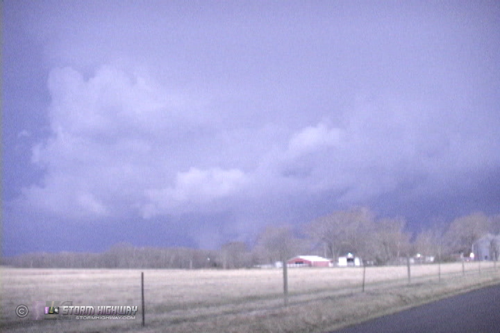
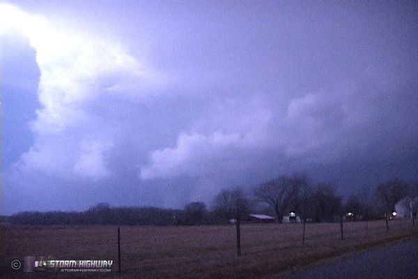 ABOVE: Possible tornado in Crofton, Kentucky on Tuesday night.

Web Site Design and Internet Marketing by CIS Internet