Starting Early: Huntington, Teays Valley & Charleston, WV, - February 22, 2003 - 5:30PM to 7:30PM Starting Early: Huntington, Teays Valley & Charleston, WV, - February 22, 2003 - 5:30PM to 7:30PM
The week of February 16-23 brought almost every type of weather imaginable to the Mountain State. The roller-coaster began with heavy snow, sleet and destructive ice early in the week; then a quick warmup by midweek; followed by severe thunderstorms, lightning, hail and wind by weekend; and finally cold, more snow and flooding by the end of the period.
Not too long ago, it was somewhat rare to see a thunderstorm in West Virginia during the winter months - but this week's events make 2003 the third year in a row when the state has seen lightning during the winter 'off season'.
EXPEDITION VIDEO: Storm Highway Video Clip - Lightning, hail and heavy rain in West Virginia on February 22, 2003. (RealPlayer required)
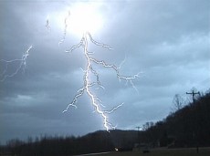
VIDEO FRAMES: Lightning strike along Route 2 near Huntington.
By midafternoon on Saturday the 22nd, temperatures had risen considerably due to warm, moist air moving northward into the area from the Gulf of Mexico. The warming trend was boosted by clearing skies which allowed the sun to provide extra heating. By late afternoon, temperatures approached 70 degrees in many locations with a strong cold front and low pressure system moving in from the west-southwest, which set up conditions ripe for strong thunderstorms. The NOAA Storm Prediction Center placed our state inside a 'slight' risk area for severe weather, the 3rd-highest risk assesment possible (moderate and high being the more serious designations). A 'slight risk' is common for this area in the spring and summer but very rare for wintertime.
Storms began entering West Virginia near Kenova around 5:00PM, so I headed west on I-64 to meet several cells closing in on the Huntington area. A severe thunderstorm watch was issued for the region by 5:30PM. After reaching Huntington and heading north on Route 2 along the Ohio River, a very active thunderstorm presented itself about 6:00PM with frequent cloud-to-ground lightning. I pulled over to catch some of the action (video frame at right) before heading back towards Charleston to get back ahead of the storm system for another round.
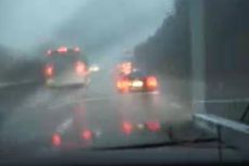
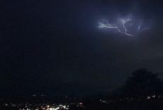
Driving back east on I-64 was difficult with heavy rain and small hail nearly all the way to Nitro. I was finally clear of the rain and ahead of the storms as I passed Dunbar and arrived in Charleston. A severe thunderstorm warning was issued for most of the Charleston area at 6:45PM. The storms could be seen looming over the city in the western sky at twilight, with an occasional lightning flash illuminating the clouds.
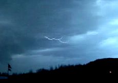
I set up both cameras briefly in Spring Hill Cemetery overlooking the city before the rain caught up with me and drove me inside for the night. One 35mm lightning strike should be on this roll of film, to be developed at a future date.
Digital Video: Sony DCR-TRV900 3CCD MiniDV, 720x480 NTSC
35mm Camera/Lens/Film: Pentax K1000 SLR, 28mm lens, Kodak 200 slides.
35mm Exposure: 15-30 seconds @ F8 |