|
I've lost more than $1 million to copyright infringement in the last 15 years, and it's finally brought an end to my professional storm chasing operation. This page is a detailed account of the biggest threat to my photography and video operation that I had to battle daily to just barely survive, and eventually could not overcome. It's a problem facing all of my colleagues as well. |
SPEARMAN, TX - The first day of my third sojourn into the Great Plains during the 2016 season started with a "bang", an intro to what would end up becoming my best chase to date. After several frustrating Midwest busts (two of which I missed Illinois tornadoes less than an hour from where I was) and two previous unsuccessful short outings in the Plains, I was in a bit of a tornado slump - with my last sighting in July of 2015. I was beginning to think 2016 would be my first year since 2009 that I would post a zero on the "tornado board". May 22nd brought that prospect to an end!
Two potential target areas were in play on this day, a triple point up in Nebraska and a CAPE max ahead of the dryline in the Oklahoma/Texas panhandle. Since I didn't want to choose a target until daybreak, I chose Salina as my overnight stop from St. Louis - which gave me enough time to easily make either target area by storm time. When I awoke and did my first data check, I was less than impressed by the northern target. The Panhandles it was!
GPS LOG: Click to view the GPS track for this chase
I arrived in Guymon, OK by mid-afternoon as congested cumulus began bubbling in several areas in the Texas panhandle. I moved south to Gruver, TX to wait for the situation to evolve before I chose a storm. At first, I was drawn toward a storm right on the dryline heading for Stratford to my west, and I began heading in that direction. But after a few radar scans, the storm seemed to be struggling, while others to my east in the open warm sector were improving. I stopped to re-evaluate, noticing a critical detail: dewpoints in the inflow region of the western storm had begin falling into the upper 50s, while the storms to the east had much more abundant moisture. Based on this information, I turned around and headed for the eastern storms, the southernmost of which was passing just south of Spearman.
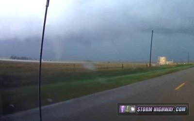
When I arrived on the Spearman storm, it had a respectable base with an RFD intrusion already in progress. This RFD cut proceeded across the road to my south, but motion in the resulting lowering seemed weak.
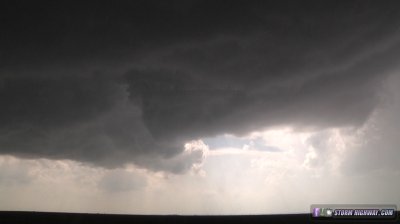
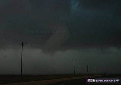
I turned east to jump ahead of the storm, and while I did, what appeared to be a funnel rapidly formed at the nose of the RFD:
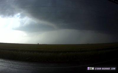
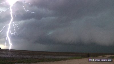
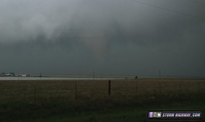
This feature was short-lived, as another storm had just developed to the south, fouling the first storm's inflow. I would have to wait for this merger to finish before continuing. Once it did, the storm quickly reorganized again, but with yet another upstream storm approaching for a second merger. The primary storm again managed to focus an area of rotation:
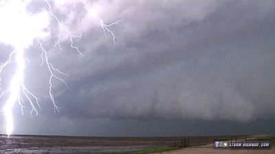
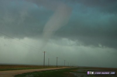
This too was squashed by the approaching cell merger fouling the inflow. Before the upstream merging storm arrived, the primary supercell exhibited rapid (but relatively cold) inflow at this point, with frequent lightning:
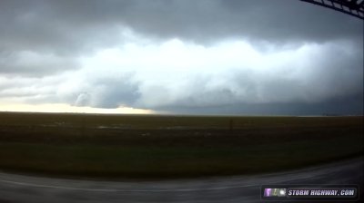
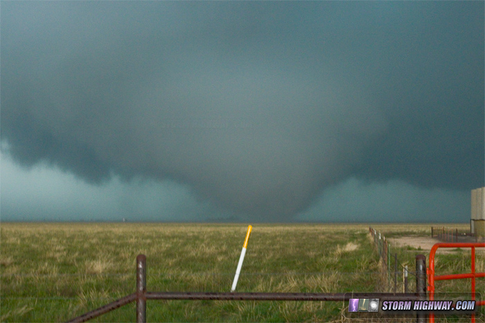
After this, I sat in heavy rain for another 20 minutes as the cell merger took place. Finally, I began to see clearing to the south. I waffled back and forth on what to do at this stage. For the first time, the storm's inflow was clear, with no immediate threat of additional cell mergers. Do I hang back for a shot at an RFD occlusion on the southwest flank of the storm, or head east for a possible new circulation? The storm made this decision for me - a wall cloud began taking shape to my immediate west. When I rolled up on this area to investigate, I could see a very strong RFD surge beginning, with rapid downward motion and a very large clear slot developing.
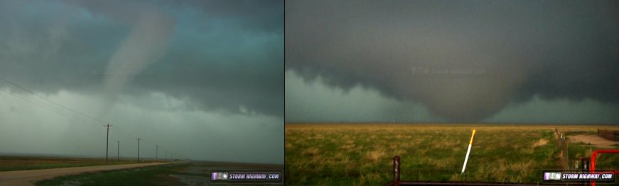
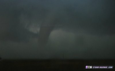
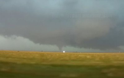
I was back on the road to keep up with this no more than a minute before the first tornado appeared within seconds as a ghostly white stovepipe, fully condensed:
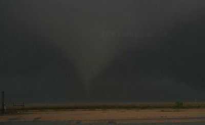
Condensation vanished briefly as I approached the tornado from the south, but re-appeared as the tornado began to narrow and enter its rope stage. It was quite dark at this point under the storm, so I was not able to capture any satisfactory still images. These are from video:
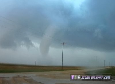
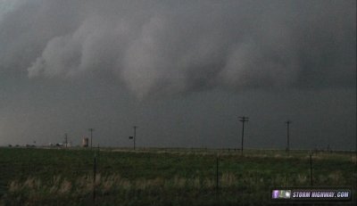
The tornado moved to within approximately 1/2 mile as it crossed the road, still weakening. It spared the telephone poles/power lines:
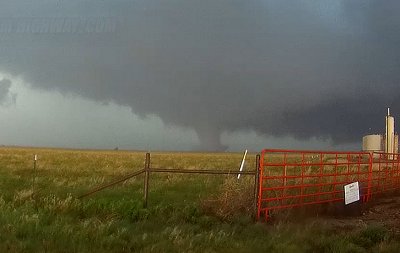
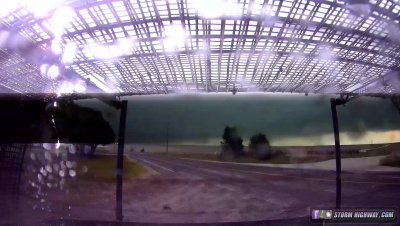
A new lowering was visible to the northeast as this tornado vanished, and I moved east to keep up. It was only a minute or so before this area produced a large and strong-looking tornado. It began as a slender stovepipe, quickly growing in width with power flashes. By the time I found a place to stop, the tornado was a stout cylinder, and still growing. It peaked out in size as a wedge, followed by a carousel of vortices, sometimes two and three at once. The tornado's roar was audible here as the classic "waterfall" sound.
After a few minutes, a very strong RFD surge sent the small group of storm chasers stopped here scurrying back to our vehicles, and I headed east again to look for the next cycle. The storm, however, had become heavily HP at this stage, with rain obscuring whatever it was doing to the northwest. I moved north into the notch of the storm to look back southwest. From there, a wall cloud was visible, but no focused area of rotation was evident. Low level inflow from all directions was strong, however - and the storm was nothing to turn one's back on! With my escape route available to the north (thanks to my hail guards), I waited to see if this area would produce, but it did not before the whole thing became obscured by rain and hail screaming in from the north. Having lost visual, I moved north farther away from the circulation, putting my hail guards to their first real test as a few windblown golfballs (estimated) smacked the side window guards loudly.
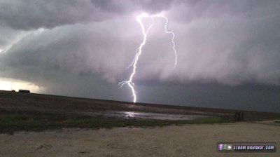
The road network here is not ideal, and I had to trek pretty far to the north to get to a road that would take me safely to the southeast and ahead of the storm again. I managed to accomplish this easily, but upon regaining visual on the storm north of Canadian, it had a cold, outflow-dominant look. As I stopped to evaluate the situation, a close lightning strike hit a few hundred feet behind me:
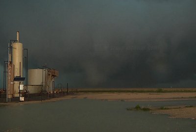
Another tornado was reported north of Canadian, but I did not see it. I assume it was with an RFD occlusion on the back of the storm.
With nightfall arriving, I decided to call it a day and head to Erick, Oklahoma for the night. I enjoyed a nice lightning show as I drove south to I-40, but didn't get a chance to take any more pictures.
Other observer accounts from this event:
NEXT PLAINS CHASE: Twilight supercell & close lightning at Turkey, Texas >