 Vivid and close lightning from Carlyle to Bartelso, Illinois: May 5, 2012 Vivid and close lightning from Carlyle to Bartelso, Illinois: May 5, 2012
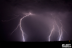
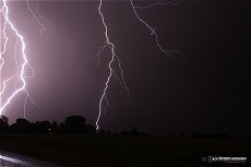
ABOVE: Close lightning near Carlyle, Illinois on May 5, 2012.
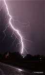
Click any thumbnail on this page to view a larger version.
CARLYLE, IL - Several rounds of mainly sub-severe storms affected much of southern Illinois during the early morning hours of Saturday, May 5. Despite the storms not having much of an impact in the realm of hail and wind, the lightning displays were cooperative for photography, and ended up ranking in my top 5 lightning chases of all time.
Strong instability was present across much of Missouri and southwestern Illinois on Friday. A warm front was situated northwest to southeast directly through the St. Louis metro. A southwesterly low level jet was expected to provide enough convergence along the front to fire storms after dark. Any storms that could develop on the warm side of the front would have good supercell potential, despite weak westerly flow aloft. As such, it was a no-brainer chase night for supercell/large hail (and slight tornado potential), and if that didn't work out, there was certainly going to be a lot of lightning. Storms stayed well northeast of the surface boundary all night, so I ended up focusing on lightning photography.
Convection had fired about 90 minutes before I left work, with most of the existing complex of storms well to the east by the time I was free to chase at 11PM. One storm near Livingston on I-55 had shown some signs of intensification and hail potential on radar, so I drove northeast to Trenton to try and observe it. However, this storm rapidly weakened, sending out an outflow led by a low but otherwise unremarkable shelf cloud. At this point, there were no other upstream storms to intercept, and what I could see to the east didn't look worth the long drive needed to chase it down. So, I ended the chase and went home, keeping an eye for development to the northwest.
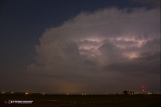
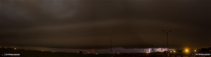
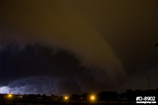
After midnight, weak convection to the northwest began to get more organized. After a few radar scans, another storm approaching I-55 (tracking along the same path as the first one) began to intensify and looked healthy enough to convince me to resume the chase. I headed up to Breese along Highway 50 to get in front of the storm. I picked a nice spot at the soccer fields north of town to sit and watch the storm approach. Storm speeds were only 20-30mph tonight, so it took the storm a good while to arrive. My first view of the storm was the entire cumulonimbus, moonlit and pulsing with frequent lightning, surrounded by clear skies. It is crossing I-55 near Hamel at this point.
A low shelf cloud was visible on the horizon, largely obscuring the base of the storm and its cloud-to-ground lightning until it was roughly across I-70 at Highland. Finally, there was enough visibility under the shelf cloud to start trying for lightning shots.
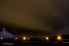
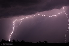
As the shelf cloud approached, its structure began to emerge in the moonlight/town lights. It then became the photo subject.
The shelf cloud's apex was more or less headed directly over Breese. The structure became quite ominous and dramatic as it approached and moved over.
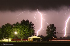
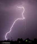
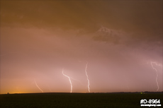
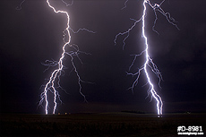
I started getting precip at my location, so I headed south to Germantown, then east on Highway 161 to re-intercept the storm. The lightning became photogenic here, with a series of vivid bolts jumping outside of the rain on the core's west flank. I decided to try and get close to this scene east of Bartelso. I set up on a county road facing north, but only one CG occured before the rain arrived - forcing me back into the truck.
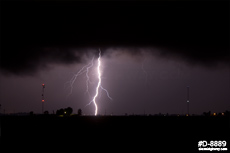
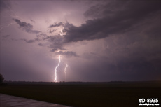
I drove another couple of miles east on 161 to get into the heaviest part of the core per the radar VIL image, but there was no hail to be seen. Thinking the show was over, I turned around westward to head home. However, several bright lightning discharges from the storm to the immediate southeast made me hesitate. I stopped to set up the camera in the direction I'd seen the earler flashes, and got this.
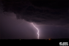
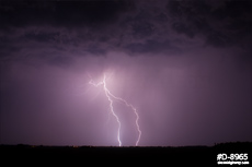
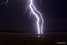
This convinced me to drive back east a few miles to get close to the storm again to try and catch a few more. I stopped about 2 miles east of Posey, and set up again. The lightning seemed to be winding down, but I picked up these two shots. The second one here was an experiment to leave the shutter open for about 4 minutes, the longest I've done a lightning exposure on the DSLR before. I thought the colors and illuminated foreground turned out interesting.
With the show seemingly over, once again, I started heading for home. However, yet another storm had developed up along the I-55 corridor and rapidly intensified, heading toward Carlyle to my north. The storm would cross Highway 127 only about 15 miles to my north, so I made the turn onto 127 northbound to meet it. Not wanting to drive into the rain, I set up on Keyesport Road, about a mile south of the core. I spent the next 10 minutes or so as an area with a CG discharge every minute or so drifted by to the north-northeast toward Keyesport.
During the next exposure, a bright blue flash lit up the landscape from behind me, followed quickly by a ripping crash of thunder. I turned around and saw nothing but the moonlight filtering through some broken cumulus to my southwest. I stood there for a minute trying to figure out if that was just a rougue clear-air bolt thrown from the storm to my northeast (a 'bolt from the blue'), or a CG from a new updraft developing overhead. At that moment I started hearing the 'ping' of small hailstones hitting my truck, then BAM - another CG explodes about a half mile to the southwest. It's a new storm going up right overhead! I jumped in the truck and raced west a few hundred yards to get on the other side of Highway 127 where a clear view to the southwest was available (the direction of the two close bolts). As I got out of the truck to set up, the third CG fired off, nailing a power line roughly a half-mile up the road. The front dashcam caught it, this is a GIF of the three frames where a brief power flashover is visible:

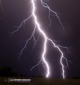
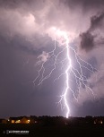
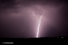
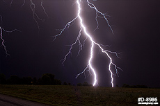
I quickly set up the camera outside, stopped down to F13, set the cable release and dove back into the truck. It is very rare that I feel unsafe to be outside shooting lightning - this time was a no-brainer! A steady but very light shower of pea-sized hail was in progress - but no rain! The fifth discharge occured directly behind me, again within a half mile (flash-to-thunder delay of about 2 seconds). After another 25-30 seconds, discharge #6 popped in the general direction I had the camera pointed. I jumped back outside to end the exposure, and looked the the LCD - got it!!! This turned out to be two channels, perfectly framed, each of which split into two before connecting to the ground. Upward leaders are visible next to the channels on the right (the second image below is a crop to show detail). The specks on this image are the small hailstones, frozen in time by the giant 'flash bulb' of the lightning:
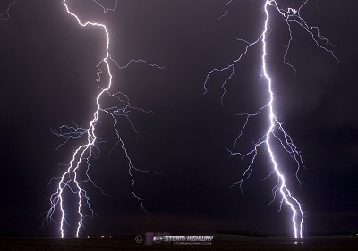
I opened the shutter again and quickly retreated back into the shelter of the truck. Another two CGs hit within 1/2 mile - one to the north, then another to the east about 15 seconds later. After another 20-25 seconds, yet another hit just to the east. The storm seemed to not be moving, as the lightning wasn't moving farther away. I jumped out and rotated the camera to point east - I didn't like the view (slightly uphill and into a grove of trees across Highway 127), but there was no time to reposition. I expected the precip core to start unloading on me at any minute (given the small hail already falling), but the rain was nowhere to be seen or heard. The next CG crashed down across the road, again less than 2 seconds flash-to-thunder delay. I jumped back out to check the LCD and start another exposure - this one was squarely in frame!
With CG intervals of about 15 to 30 seconds, I had just enough time to jump out to close and open the shutter immediately after each strike, then retreat back to the safety of my truck. Power lines next to the road likely provided some protection, but I wasn't taking any chances. I was more afraid of the camera getting struck at this point and losing the shots I'd already caught. Two more CGs to the east occured in frame, but off to the left side. Both of these had flash-to-thunder delays of 2 to 3 seconds.
Finally, big raindrops began splashing down among the hail, signalling it was time to pack up and move. No sooner had I turned the truck around to get back on Highway 127 than the downpour finally arrived. As I drove south, the lightning was still going strong, but now was in the middle of the precip. With it well past 3AM, a nearly full memory card, and the feeling that nothing I'd get now would top what just happened, I finally decided to call it a chase and head home. The storms would have been good for lightning shots up until sunrise - they kept on flashing in my rear view mirror all the way back home.
Clear-air, crisp, close and rain-free CGs are a lightning photographer's dream. It happened this night, making it one of my best and most memorable lightning chases of all-time.
Great night for you, Dan. Super shots.
- Posted by Terry Pallister from New Orleans | | |
Thanks Terry! Definitely a great night to be out.
- Posted by Dan R. from New Baden, IL | | |
|


