  Supercell and close lightning from Urbana, IL to Terre Haute, IN: May 7, 2011 Supercell and close lightning from Urbana, IL to Terre Haute, IN: May 7, 2011
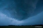
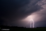
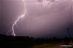
ABOVE LEFT: Close lightning near Terre Haute, IN; RIGHT: supercell near Newman, IL.
Click any thumbnail on this page to view a larger version.
TERRE HAUTE, IN - Supercells developed in advance of a surface low moving through central Illinois and Indiana on Saturday, May 7. I had noticed potential for this day when short-term models fired additional convection later in the afternoon in the wake of an early-morning thunderstorm complex that had just moved through. Wind fields were supportive of supercells in advance of the surface low, and clear skies were allowing for ample destabilization and surface-based instability. Models initially suggested the storms might develop along the I-72 corridor west of I-55, moving southeast toward the Effingham-Mattoon area. But as the afternoon wore on, cumulus fields began developing from Burlington, Iowa east to Peoria and Bloomington, IL, much farther north and east than I had first expected. Upon seeing this new development, I hurried out the door and was on the road northbound by 2:30PM.
When the first storm finally exploded east of Bloomington just after 3PM, I considered turning around and heading back home. I still had almost 3 hours to go before I would reach the storm, and I felt that it would likely tornado early on, moving eastward even farther out of my reach. However, after a few radar scans, the storm began turning more to the south - which meant less of a drive. Furthermore, it also appeared more storms would fire to the west and move even closer to my direction of travel. The first storm, just north of Champaign, developed a circulation and went tornado-warned shortly after it made its right turn. I was still 100 miles away.
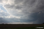
I could see the tops of the storms at Effingham, and as I drove north on I-57 near Mattoon, a horseshoe funnel appeared to the northwest:
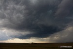
The storm near Champaign finally lost its circulation, and did not regain it. More cores were developing to the storm's immediate west, and I thought all of this might indicate the storms were developing into an outflow-dominant MCS. However, I was finally closing in by now, so I continued on. Soon, a new updraft went up on the southwest edge of the previous storms. It was close enough for me to see, only 20 miles or so to the north of Highway 36 off of I-57. I headed north a short distance to keep an eye on this new storm. A rain-free base and vault were evident:
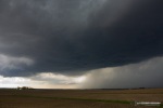
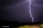
I finally reached the storm near Longview, IL and parked to see what it would do. Its large rain-free base was impressive. Southerly surface inflow increased dramatically at this time. These views are looking north.
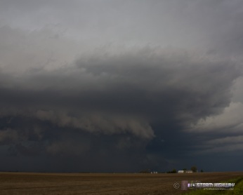
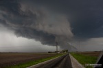
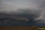
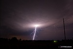
Despite the strong inflow and rain-free base, the storm was still high-based. A few minor RFD cuts developed, but without any corresponding motion or lowerings. Finally, a band of clouds began to condense under the base, quickly growing into a menacing shelf cloud - but all due to rapidly surging outflow:
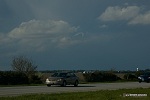
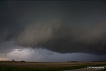
A small channel of surface inflow was still feeding into the storm to my due north, so I stayed put until this too got blasted to pieces by outflow a few minutes later. Outflow was now surging south far ahead of the updraft, and unfortunately this was the story for the rest of the evening. Other than winds shifting southerly when I drove far ahead of the storm, no southerly surface winds were present close to the updrafts. The storm was staying discrete and very potent looking structurally and on radar, so I decided to stay with it in case it managed to establish good inflow at some point. These are views of the storm from Newman to Vermilion. the last shot is outflow-driven dust and debris crossing the road near Edgar:
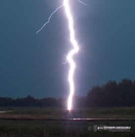
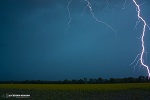
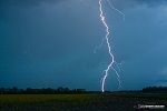
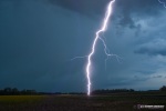
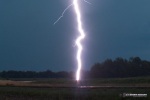
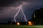
I continued ahead of the storm through the Terre Haute metro area, skirting the city to the west and heading south along Highway 150. Cloud-to-ground lightning activity along the storm's forward flank was very frequent and intense, and so I found an open field south of Terre Haute to try to catch a few. Due to the still-daylight (close to twilight) hour, I stopped down to F9 and did 3-second exposures, catching a few decent bolts over the Golden Ragwort wildflowers:
  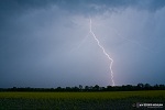
Then finally, the trip was made. For the first time since 1998, an extremely close lightning strike at a distance of 1/10th of a mile hit dead-center in my camera's frame, with the shutter open. An upward leader is visible to the right of the main channel's contact point with the ground, only the second time I have captured one in 18 years of lightning photography. The following is the full frame followd by a crop of the ground contact point:
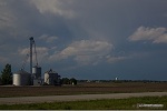
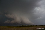
With rain and hail catching up, I moved south again - stopping for one more shot of the storm's structure:
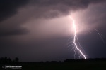
With darkness taking over, the focus turned entirely to lightning as the forward-flank CG barrage continued unabated. The following were captured between Jasonville and Switz City, Indiana:
Other chaser reports from this day:
cool pics! congrat on that close lightning shot, thats awesome! you were in your truck I hope :)
- Posted by Michael Thompson from MN | | |
Dan, Your images from May 7, 2011 are so amazing and inspiring. Stay safe.
- Posted by Neal Green from Santa Ana, CA | | |
Thanks Michael and Neal! Hopefully the storms will keep cooperating!
- Posted by Dan R. from New Baden, IL | | |
if structrual steel is used for the down conductors of a LPS system, should the steel be isolated /insulated INSIDE a public building,eg supermarket,school,hospital.
If not,surely any contacts from humans inside the building could lead to injury/death
- Posted by Alan from UK | | |
Alan, structural steel frames almost always will provide good lightning protection for building occupants. Anomalies are always possible, but I am not aware of any documentation of injuries or deaths to occupants from strikes to these types of buildings.
- Posted by Dan R. from New Baden, IL | | |
|


