July 29, 2000
Saturday was one of the few times that observing a storm in West Virginia paid off.
Usually, storm systems in Appalachia are too dynamic to chase. By the time you can get in the car and catch up to an active cell, it's already fizzled out. That wasn't the case this night.
At 8:00pm, radar was showing storms moving into Southern West Virginia, with the strongest cells on the southern edge of the line. Charleston was going to get some lightning, but it was clear that the Logan, Boone, and McDowell County areas were about to experience the best of the storms. I got in the truck and headed south on Corridor G (Rt. 119).
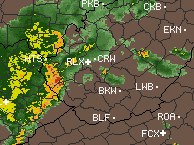 Just past Danville at 9:15pm, the sky was really flashing. This time the storms weren't dying out on me. In fact, I ended up directly in the path of the strongest cell in Chapmanville, in northern Logan County (radar at right). I pulled off of the road and set up the camera out of the passenger side window facing west. Cloud-to-ground lightning was close and occuring in all directions. Just past Danville at 9:15pm, the sky was really flashing. This time the storms weren't dying out on me. In fact, I ended up directly in the path of the strongest cell in Chapmanville, in northern Logan County (radar at right). I pulled off of the road and set up the camera out of the passenger side window facing west. Cloud-to-ground lightning was close and occuring in all directions.
Though I missed two very close strikes that hit behind me, these two flashed in the camera's view. The storm that moved through Charleston at the same time turned out to be rather weak, which made my 40-mile (one way) drive worth it.
< Back
GO: Home | Storm Chase Logs | Photography | Extreme Weather Library | Stock Footage | Blog
Featured Weather Library Article:
|


