
May 15-23, 2001
This is one of those weeks that storm chasers love - to hate.
Starting on May 15, very nice storms popped up all over the state just about every day and night. But the story for all of them was the typical one for May weather - heavy rain, with the good lightning embedded right in the middle of it. Thus arises the challenge: Driving through the mountains on the interstate in pouring rain at midnight trying to find a spot protected from the rain with a nice view. In other words, next to impossible. But if you don't try, you'll never know.....
This week's storms dumped over 8 inches of rain in most areas of the state, breaking Charleston's all-time rainfall record for May and causing moderate to severe flooding that took the lives of three people.
Tuesday, May 15 - A train of storms began to develop and move southeast along a straight line from Parkersburg to Fayetteville around 10:00pm. The storms were numerous, slow-moving and full of electricity. The night skies were dark and quiet in Charleston, so I headed north on I-79 and got in the middle of the fun at Wallback in Roane County.
The interstate overpass at Wallback is the only good place to set up for miles around, and this storm is getting ready to hit head on. As I set up the cameras, the lightning arrived with several loud crashes, then a very close strike just to my east (RealAudio clip, 234KB). Missed them by about 2 minutes.
Another cell was firing off to the south, so I raced it down to Amma through the heavy rain. But after setting up, it was apparent it had won the contest and was heading over the mountains and into the night, leaving me soaking wet in the trailing rain shield. Lost that one too.
After the 100 mile chase, I got home around 1:30pm and called it a night.
Wednesday, May 16 - I was getting ready to relax after a day at work when I get a call from Bill Coyle in Va. Beach that there is a nice cell flashing away to my west. I wasn't expecting it, because NWS had downgraded my forecast to only showers.
At Bill's advising I headed south into Boone County at 11:00pm and hit this cell dead center. The lightning was frequent, close and intense, leaving afterimages in my eyes. But it was raining so hard I could barely see the road, let alone stop and set up. Finally in Chapmanville in Logan County (50 miles south of home) I found an overpass, but the rain was so heavy the resulting spray kept me from shooting even there.
As I was going home, the rain died off some and I met a few small cells with intracloud activity about 10 miles from home around midnight. I drove up a small, very rough dirt road leading up the mountain to a clearing where I could shoot. But the lightning never came out of the clouds, and it started raining again so I went home.
Turns out that mountain road tore up my right front tire, when I started to go to work this morning it was completely flat.
Another 110 miles, no score. Chalk up another point for the storms.
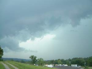 Thursday, May 17 - Checking the radar around 3:00pm showed a strong line of cells racing toward my office in Teays Valley. I headed outside as the ominous clouds began rolling over Scott Depot (at right). I could see the lightning approaching, but once again the rain was to arrive first. These storms moved on east and left the area ready for another round. Thursday, May 17 - Checking the radar around 3:00pm showed a strong line of cells racing toward my office in Teays Valley. I headed outside as the ominous clouds began rolling over Scott Depot (at right). I could see the lightning approaching, but once again the rain was to arrive first. These storms moved on east and left the area ready for another round.
At 10:00pm, again I hear from Bill in Va. Beach about some small cells forming to the west. At this point I'm leary of once again putting more miles on my truck for nothing, so I decided to stay in town and let these things come to me. I drove up onto Fort Hill and set up for about 25 minutes while a few cells tried hard to put on a show over Charleston. They quickly died out, leaving the rest of the line northwest of town the task of the fireworks display.
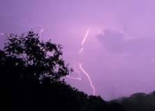
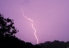
But the performance was disappointing. I went home and set up the cameras pointing out my living room window while several small, weak cells trained over town for the next 3 hours. A few unimpressive, distant strikes made it onto film (below). Finally, at 1:30am the sky was dark- and once again I called it a night.
From Thursday night - click to enlarge
Friday, May 18 - After work, I called in an order for Chinese food at Main Kwong. I hadn't been paying much attention to the weather, I had already checked the radar and saw nothing more than a line of heavy showers moving toward me from the southwest. I went downtown to pick up my dinner and was met immediately with a ominously dark sky to the southwest. I flipped on the scanner and heard severe t-storm warnings for just about every county in the area. Tornado warning for Wood County, 45 miles to the north. Okay, I guess I should be getting ready right about now.
I made it up on top of Spring Hill Cemetery ridge about 10 minutes before the action hit, which ended up being quite disappointing in light of all the hype on the scanner. A foggy curtain of heavy rain moved quickly over the city and toward me. "Come on, at least on strike before the rain hits...." No such luck. When the first drops arrived, I grabbed the cameras and dove into the truck. The lagging lightning finally dragged through town about 20 minutes later.
The only interesting thing about this storm was the advancing rain, which looks pretty neat on video when you fast-forward the tape. A clip will appear on the site sometime in the future.
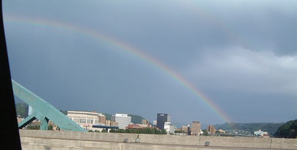
Wednesday, May 23 - The big upper-level low squelching the storm action in the Plains brought some small storms to the Charleston area this afternoon. Nothing spectacular, except for the sun illuminating the back of the line of cells creating a rainbow over downtown (below).
That's about it. Lots of rain, lots of lightning- no worthwhile catches. Will keep trying though....
< Back
GO: Home | Storm Chase Logs | Photography | Extreme Weather Library | Stock Footage | Blog
Featured Weather Library Article:
|


