|
Home | Blog Index | Blog Archives | Christianity & Faith Essays | Storm Chasing Essays
The top 5 dangerous bridges in the Charleston area
While the Fort Hill (Oakwood) Bridge on I-64 in Charleston is probably the most notorious and most accident-prone stretch of highway in the state, there are other bridges in the area that have high accident rates during the winter season. When icy bridge conditions exist in the Charleston area, the following bridges are nearly certain to experience accidents. The primary risk factor on these spans is their curved configuration, which prompts drivers to apply brakes and attempt to steer, actions which at high speeds can lead to a rapid loss of control on ice.
#1: The Fort Hill Bridge - Interstate 64
The Fort Hill Bridge on I-64
While this location certainly needs no introduction on this site, any list of accident-prone spots in the Charleston metro area would be incomplete without it. The bridge's main problem is its surprise 90-degree turn across the Kanawha River at the same location that exit and entrance ramps for Oakwood Road snake onto the main lanes of the highway. The bridge deck is hidden by the sharp curve and by the crest of a small hill on the approach - and not visible to oncoming motorists, meaning that if the bridge is iced over, drivers cannot see it until it is too late. While accidents are most frequent during snow in the winter, even light rain can make the curve impossible to navigate for cars traveling at or above the speed limit. Even when going the 60mph speed limit, drivers will feel the strong 'pull' that the curve exerts on their vehicle.
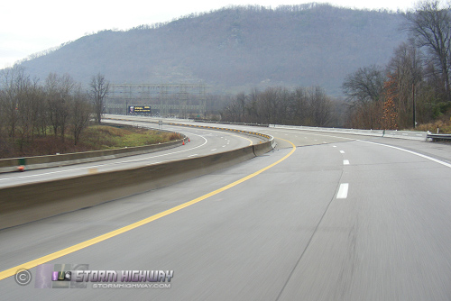
#2: Dunbar/South Charleston bridge - Interstate 64
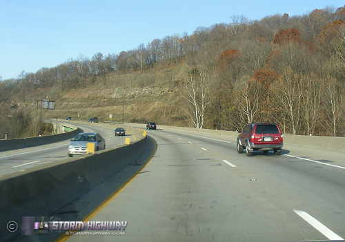
The Dunbar/South Charleston Bridge on I-64
This bridge carries I-64 across the Kanawha River just west of the MacCorkle Avenue exit in South Charleston and just east of the Dunbar exit. It has a nearly identical risk configuration as the Fort Hill bridge, in that eastbound drivers encounter a sudden, partially hidden sharp curve on the very start of the bridge deck's western end. A new bridge is currently being built at this location which will carry all eastbound traffic, converting the existing bridge into an all-westbound configuration. The new bridge will feature a more gradual curve for eastbound vehicles, reducing the hazard of this location when construction is completed. Westbound drivers will still encounter the old bridge's sharp curve, but the element of surprise is reduced due to any icy conditions being visible long before the curve.
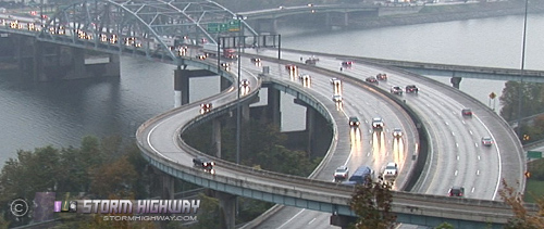
#3: I-77/I-64 interchange/viaduct - Charleston
The I-64/I-77 Interchange
This interchange and section of elevated viaduct in downtown Charleston is also the site of frequent accidents, with numerous curved ramps culminating in a long, sharp curve before the Leon Sullivan Way exit. Most of the highway here is elevated, meaning it ices first during snowfall events. While the element of surprise is somewhat lessened here due to the length of elevated highway on the approaches to the curves, the sharpness of the curves mean that the accident risks will still be high during icy conditions.
#4: Little Sandy Bridges - Interstate 79, Elkview
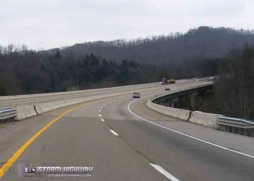
The Little Sandy Bridges on I-79
Drivers on I-79 north of Charleston will encounter this dangerous location between the Big Chimney and Elkview exits. These sharply-curving bridges carry the lanes of I-79 over Little Sandy Creek valley, and accidents are common here in the winter. There is no artificial lighting at this remote, rural location, meaning that the hazards of the bridge are especially hard for drivers to see at night. The speed limit here is 70mph, meaning that when crashes happen here they tend to be worse than other locations. Many serious ice-related pileups have occured at this spot over the years.
#5: Cabin Creek bridges - Interstate 77, Chelyan
The Cabin Creek Bridges on I-77
The Cabin Creek bridges are two pairs of spans that carry I-77 over Cabin Creek and a CSX branch railroad line. They are located on a long, sharp curve which carries the highway away from the Kanawha River Valley into the Cabin Creek Valley, just east of the Chelyan exit and just west of the first toll plaza on the West Virginia Turnpike. While the speed limit here is 60mph, drivers taking the curve at or above those speeds will not be able to negotiate them if the bridges are iced over. Accidents are common at this location regardless of weather, but as with the other bridges, the risks are elevated even more during icy conditions.
|


