|
Home | Blog Index | Blog Archives | Christianity & Faith Essays | Storm Chasing Essays
February 11-12 winter storm updates
This is an ongoing blog post about the current storm affecting the Ohio Valley and Appalachian regions. New updates are listed first.
1:43PM Tuesday: Part 1 of this winter storm is a wrap - temps rose above freezing here in the Kanawha Valley long before the precip arrived, keeping everything rain. Huntington remained below 32F with freezing rain most of the morning, but so far I haven't seen reports of any major problems there. After intermittent rain this afternoon and tonight, part 2 of the storm arrives tomorrow after the passage of a cold front. The window for snow behind the front appears to be brief, suggesting a low impact event.
7:51AM Tuesday: Looks like I managed to drive around the only areas that didn't see accidents in yesterday's icy road event, as Kanawha County reported more than 100 crashes during the quick burst of snow (News Article). It's remarkable that Oakwood escaped crash-free during this event.
The drying effects of southeast wind flow over the mountains have been keeping further precip from reaching Charleston overnight. Quite the line of thunderstorms has developed to our southwest, and though lightning data doesn't show anything upstream of us yet, I wouldn't be surprised to hear some thunder here before the morning is over. Lexington is at 34F now, which shows the warm air is making headway. We're still in the 20s here, so it will be interesting to see what the precip type is when the line of showers/storms arrives in the next two hours or so.
9:41PM Monday: Picked up a quick inch here in Charleston. I filmed the Oakwood Bridge for 90 minutes - but since the widespread snow had everyone keenly aware of the conditions, people were wisely taking it slow around the curve - no problems to report there. The big impact with this snowfall seemed to be the hills around town. I didn't see any accidents, but cars were getting stuck everywhere. I think the highway crews were caught off guard, as I only saw three salt trucks cross the Oakwood Bridge in that hour and a half. On Corridor G southbound between MacCorkle and Oakwood Road, dozens of cars were stuck on the hill, unable to move. Some people left their vehicles and walked home. Oak Ridge Drive was impassable, with traffic backed up on Greenbrier Street. The roads were very slippery, but nonetheless I didn't see one spinout or crash anywhere in town. I'm sure there were many of them somewhere, just nowhere on the main roads in town that I could see.
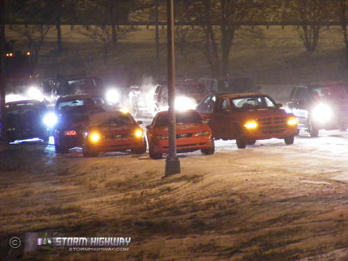
Vehicles stuck on Corridor G
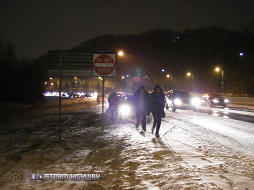
People abandon their vehicles near Cantley Drive
Things are still pretty slick out there - but as I've mentioned before, with the video market the way it is now, it's not worth putting any more time into that I already have tonight. The precip shield has moved north of the area - right on cue as the models said it would - so I think we may be done for the night. Another batch of snow in Kentucky could scrape by us later tonight, so I'll be keeping on eye on that. Other than that, I'm sitting down to dinner and relaxing for a while.
6:52PM Monday: Snow has started falling and sticking here in Charleston. Out the door for a while...
6:41PM Monday: The Herald-Dispatch webcam shows that snow is already coating the roads in Huntington. The models predict that most of the precip will lift north of I-64 not long after it starts, limiting the impacts in Charleston. The Jackson radar does however show an area of moderate snow heading in the direction of Charleston, which could put down a quick dusting in the next hour or two.
5:57PM Monday: Radar shows the first precip echoes entering West Virginia at this time. However, with temperatures in the mid 20s and dewpoints at or below zero, the very dry air is preventing this initial precip from reaching the ground. As the precip continues, dewpoints will rise as the lower levels of the atmosphere saturate - eventually allowing the snow to reach the ground. The automated weather observations and the Herald-Dispatch webcam in Huntington show no snow falling there yet, despite a moderate radar echo overhead. The Louisville traffic camera network shows that roads are already covered with snow, all the way to the east side of the metro. A Lexington camera shows no snow on the ground yet, though the sky does appear as if precip has started falling there.
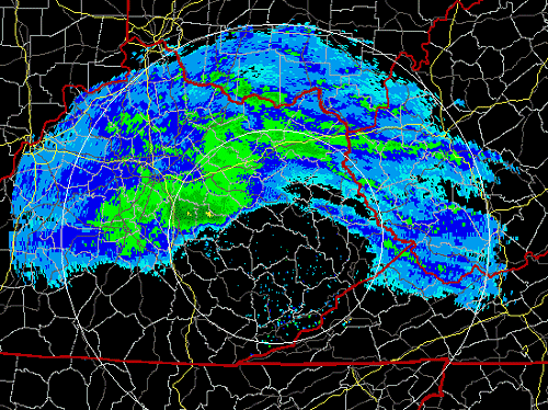
Jackson, KY radar - 5:57PM
The echoes in eastern Kentucky on the Jackson radar are quite strong, and have already triggered the radar to go into precip mode. That indicates that it may not take very long for the lower levels to saturate, allowing the snow to start. At any rate, it's time to go into 'standby mode' here and watch things more closely. We could be seeing the first flakes here within a couple of hours.
|


