|
Home | Blog Index | Blog Archives | Christianity & Faith Essays | Storm Chasing Essays
Raleigh snowstorm update: 1:26PM
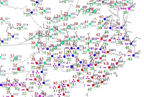
Cold rain has been falling here in Raleigh all morning, but so far the temperatures haven't. That should change here in the next few hours as the Arctic air filters in from the northwest. Greensboro is already reporting snow while at 39F, which indicates a good amount of subfreezing air above the surface. The precip shield upstream to the southwest is extensive, suggesting that there is plenty of time for a changeover before things dry up later overnight.

Temperature trends to the west suggest that Raleigh my not fall below the freezing mark until late tonight, even though the snow should be falling long before then. What this would mean is that the snow may stick only to grassy surfaces and not much else. Roads (particularly bridges and overpasses) won't begin icing up until we drop below 32F, which could be as late as midnight.
Snow is falling heavily in northern Alabama at the moment, with temps already below freezing there. That should be an indication of what the Triangle may be seeing later tonight.
|