|
Home | Blog Index | Blog Archives | Christianity & Faith Essays | Storm Chasing Essays
More March 19 photos/chase log
I went ahead and logged a chase report with a few more photos from Wednesday (click photo below).
March 19, 2008 chase report/photos
Upcoming weather roundup
Tonight's model runs are trying to give me some hope that my 'no more winter weather' suggestion I made a few days ago won't be busting utterly. Our temps will definately be cold enough to support snow Saturday night and Sunday morning.
However, the precip forecasts show very little in the way of QPF for this time period. Just some flurries/a dusting in the mountains is all that's showing up at the moment.
Some heavier precip shows up for Saturday evening, however - but temps should be warm enough to keep it in liquid form in our region. The kicker is a timing issue - if the precip arrives a few hours later than expected (after temps drop), then we could be dealing with a dusting of snow and icy bridges on Easter Sunday morning.
Earlier this week, the models showed that the upcoming Monday and Tuesday did seem to hold some potential for snow, but the latest model runs are keeping all precip well to our north into Pennsylvania. After that, we are shown to be warming up to the point that frozen precip is less likely later in the week. All in all, the forecasts for snow/ice in the coming week seems very conditional - that is, no very strong signal for measurable precip and subfreezing temps to coincide. As always, that can change with time, so it's still something to monitor.
As for that huge trough for the end of the month I mentioned a couple of times recently, the GFS has toned it down a bit in recent runs. It's still there, but not quite as amplified and not nearly as cold at the 850mb level.
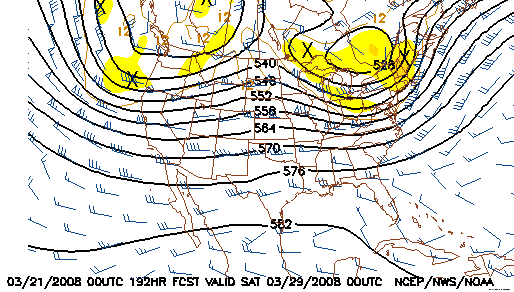
GFS 500mb forecast for March 29
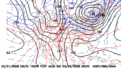
GFS 850mb forecast for March 29
So could we really be done with winter? If we can make it through Tuesday without a dusting of snow, just maybe....
|


