|
Home | Blog Index | Blog Archives | Christianity & Faith Essays | Storm Chasing Essays
Spring finally winning the battle
Update 4:28AM Monday: Looks like we may have made it! Not much left on radar, and the few flurry echoes that remain in Ohio are dwindling and moving northward. Skies are clear outside around Charleston resulting in some widely varying temps - 34°F downtown, 25°F in Teays Valley and 32°F on the hilltops adjacent to the city. We now begin a slow warming trend that should take us to 70°F by the weekend. Models show cold air remaining to our north in Pennsylvania on the other side of a very sharp frontal boundary, but this looks like it should remain safely out of the picture for Charleston. The long-range GFS is varying greatly run-to-run right now, so commenting on its outlook is even more pointless than usual. I'll wait for it to stabilize some before trying to glean anything from it.
Update 10:19PM Sunday: As expected, precip echoes on radar are drying up rapidly with the loss of daytime heating. According to the WVDOT, the only icy spots on roads being reported currently are in the mountains at Beckley and points east. In Ohio and Kentucky, no reports of icy road conditions are showing up. Here in Charleston, our temps have held steady in the high 30s for the past couple of hours, and looking at obs upstream, there really isn't that much in the way of cold air at the surface moving in our direction. That means our better source of cooling tonight will simply be the diurnal cycle (IE, loss of solar heating) rather than cold air advection from the northwest. Based on radar trends and the loss of precip over us on the 00z NAM/WRF and RUC models, I can almost call it a winter and say that we're safe from icy roads tonight - and maybe for the season. This is looking more and more like the last time we'll see this threat until next winter! A couple of rouge snow showers in Ohio are worth watching for a while, but they'd need to hold off until we can cool down a few more degrees to cause problems on the roads. Next weekend's trough is still a fly in the ointment, but I think the chances for road-coating snowfall in Charleston with it are very slim. All that said, I'm not 100% comfortable saying for certain that winter outside of the mountains is done - but I'm getting much closer.
Update 7:42PM Sunday: The clouds pushed back to the north early this afternoon, keeping the sun at bay and holding our maximum temperatures down into the low 40s. Aloft, the air is well below freezing, evidenced by the snow showers sweeping across Charleston this afternoon. So winter wins this round. With the surface seven degrees above freezing, nothing is sticking nor will it be for a while. None of the models showed the snow this afternoon, which is giving me doubts on believing them about what tonight holds in store. For now, all I have to go on is radar, which shows a long train of snow showers stretching back through Illinois. Some if this appears semi-convective (supported in part by instability from mild surface heating) and therefore may die down some after the sun sets. However, with a slight upslope wind component, I think some of this activity will last through the night. Visually, some of the snow in Charleston appeared "convective enough" to support lightning, though I haven't seen anything yet showing up on strike data maps. When temps finally drop below 32°F later tonight, any of these snow showers will start posing the usual threat to bridges and overpasses. I don't expect to see much, if any, icy road issues apart from the bridges. It does look like I'll have one more sleepless night on icy bridge coverage standby tonight.
Update 9:17AM Sunday: We were below freezing - but dry - for sunrise service this morning in Charleston. Quite a bit of cold air and spotty precip upstream to our northwest, though. I think we might end up having to deal with a little snow tonight if the models are right about temps. If we can clear out our clouds before noon (which seems to be happening), stay sunny for most of the day and get our surface temps up into the mid 50s, we just might have a harder time reaching the freezing mark tonight. That's a long shot though, with all the cold air spilling in from the northwest both aloft and at the surface - which will be fighting against any warming the sun can accomplish. We'll see what the 12z model runs say when they come out around noon.
Update 2:21AM Sunday: Radar echoes are on the downturn, with not much left other than some light drizzle or flurries. The obs at the airport showed some light snow, but I saw nothing but light drizzle here at the house. With temps still at 35°F at 2AM, it looks like we're safe from icy roads tonight and through Easter Sunday morning here. Another small chance for snow hits us overnight Sunday night into Monday morning. The models show spotty light precip around us during this period, but none over Charleston. The NWS is giving the snow a 20% chance.
Some interesting prospects showing up with the big trough advertised for next weekend. The GFS is starving its cold side for moisture, limiting the chance for snow. However, it is trying to give it a good low-level moisture plume either overtop of us or very close to us prior to its arrival, which could turn out to produce a notable severe weather event in or close to West Virginia. More on that in a future post!
2:55AM Saturday: Winter and spring are still fighting for dominance over southern/central West Virginia for this last half of March. I've been rooting for the latter, but it's going to be a close game. Winter has the bases loaded for tomorrow with two outs in the eighth inning. It has the subfreezing temps locked in for Saturday night/Sunday morning, and all it needs is some precip to score some snow here. The WRF/NAM and GFS both indicate it may get it after midnight Saturday.
It also looks like winter will get some heavy hitters in the ninth when the next trough arrives. The operational GFS has re-established the big trough for the end of the month, completing another of its trademark flip-flops. The ensembles also tend to support a general eastern US trough pattern for this same period, which gives the shaky long-term operational GFS more credibility this time.
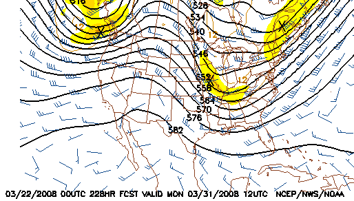
GFS 500mb forecast for March 31
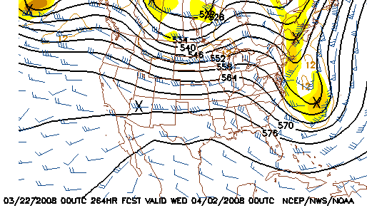
GFS 500mb forecast for April 2
850mb temps are very cold over us on these latest runs - but we may be looking at another typical GFS overzealousness on the extent of the subfreezing air. Everything is too close to call as to whether we will have to deal with icy roads again. Looking at the models, I don't think we can think about calling it a finished winter season until at least the first week of April.
|


