| Home | Blog Index | Blog Archives | Christianity & Faith Essays | Storm Chasing Essays
November 10, 2002 outbreak - 7 years ago
CHASE LOG: November 10, 2002 chase log
Today is the seven-year anniversary of the November 10, 2002 severe weather/tornado outbreak across the Midwest/Ohio Valley - 83 tornadoes, 17 states, 36 dead. Ohio was hit hard, including the Van Wert F4. Tennessee had two F3s and a high toll. Even West Virginia was inside of an SPC High Risk area that day, an incredibly rare event. I covered this system in central Kentucky, which saw no tornadoes but received significant wind damage (chase log).
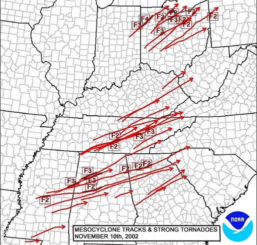
11/10/02 tornado tracks and ratings
It is events like these that underscore the fact that in the United States, tornado season never really ends, and danger is not limited to traditional 'tornado alley'. Outbreaks can happen at any time of the year just about anywhere. In fact, fall and early spring are when areas from the Mississippi River to the Atlantic coast are most likely to see big tornado events. I have embarked on tornado chases in November several times, and am always on the watch for potential outbreaks this time of year.
The reason that fall can bring severe weather outbreaks is because the upper-level wind patterns during the season transition tend to feature strong troughs - dips in the jet stream that orient powerful upper level winds over the country. When warm, moist air can get established in the low levels underneath these winds, the basic ingredients for severe weather usually come together: moisture, instability, lift, and shear. Given the right balance of parameters, events like November 10, 2002 can occur. We've already seen several powerful upper troughs this year, as we do most every fall season - however the low levels have failed to destabilize relative to the atmosphere's upper counterpart. But the potential is there with every upper trough - and so we should always be on the watch. November 10, 2002 is proof enough for that.
|


