| Home | Blog Index | Blog Archives | Christianity & Faith Essays | Storm Chasing Essays
*** WINTER STORM UPDATES ***
November 16-22 snowstorms: Storm #2 ending this afternoon
Update 2:29PM Tuesday: While a few snow showers continue this afternoon, I think we're done with storm #2 as far as road problems and further accumulations go. It's a good thing too, as I've finally been able to get some sleep. Charleston picked up a good 2 inches throughout this event. Snowshoe reports 20 inches of new snow in the past 24 hours! Other reports show totals of around 5 inches up around Beckley and Summersville, enough to make it worth a photo trip in the morning.
As far as our icy bridge episode this morning, it is interesting that Carter/Oakwood/Fort Hill escaped incident while other bridges to the west experienced pileups. It looks like crews were diligent about salting in Charleston, and from what I saw, most of the trucks working on I-64 in town were city rather than state vehicles. It's possible that the city's extra presence is what saved drivers from problems this morning on the Fort Hill bridge. The other factor includes timing - morning rush-hour traffic tends to back up and slow down on the interstates in Charleston, and therefore it is harder for cars to travel fast enough to wreck. Some of the crashes to the west resulted in the closure of the highway, which would have limited or eliminated the eastbound traffic on the bridge where most accidents occur.
After a break tomorrow, the attention will turn to storm #3, which both the GFS and NAM/WRF now show peaking on Friday morning. The GFS has the storm starting earlier on Thursday afternoon, while the WRF/NAM brings it in the next morning. Both show this event as being stronger than previously thought, bringing another significant accumulation to the mountains and possibly an inch or so here in Charleston.
The original storm #4 for this weekend has come and gone on the GFS model the past several days, but it has been nonexistent on the past few updates. While the weekend is out of reach of the NAM/WRF forecast, I don't expect it to show storm #4 being of any consequence.
* * *
Update 8:56AM Tuesday: Reports indicate several icy bridge crashes this morning, though none have been reported yet at the Fort Hill Bridge. I monitored the bridge all night and did not chase any crashes there, as salt crews had treated the road.
* * *
Update 1:03AM Tuesday: We appear to be nearing a lull in the action, as the main precip cluster is moving out with nothing immediately upstream in Ohio. All models show redevelopment and increased snow shower activity by sunrise, however. With upslope snow, precip can develop overhead without activity moving in from the west. So, I'll be keeping a close watch on this through the early morning hours.
* * *
STORM INFO: WV Road Conditions | NWS Watches and Warnings
LIVE CHARLESTON CAMERAS:
 
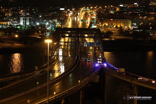
Update 10:16PM Monday: Taking a short break between snow bands. Charleston has an inch and a half on the ground from the past three hours, most of it from two very intense bands that passed over starting around 7:30PM. There has already been one accident tonight on the Fort Hill Bridge, which I missed because it was a high-speed wet-road hydroplane wreck rather than a snow-related one, not unusual for the bridge anyway. I had the camera set up, but wasn't rolling tape because there was no ice on the bridge. Some quick photos from the past hour:
click to enlarge
click to enlarge
click to enlarge
Still a long night ahead, more to come....
* * *
Update 7:16PM Monday: Just made the rounds to the usual spots around town, and found a temp gradient between 35°F in the valley and 32°F on the hilltops. The hilltops (including at my house) are accumulating snow on grass, roofs and parked cars. My circuit tonight included my 'test bridge' over I-79 between Big Chimney and Mink Shoals. That little hilltop overpass is usually the first one to start icing up, long before the ones in the valley do. I always check it first when temps start dropping during snow. It hadn't started accumulating snow yet, so I think we are safe for at least another couple of hours. Temps have fallen below freezing out west, however, and that air is headed this way.
I set up the ground camera (for precip monitoring) at the house just now, so you can watch this event live from both ridgetop (my house) and valley (downtown) locations:
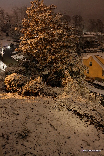
As you can see, part of my back porch is already covered as of this posting.
* * *
Update 5:51PM Monday: Storm #2 is ramping up here in Charleston, with already a dusting on the ground and on parked cars. Snow will only intensify as the night goes on, and temps are already at 32°F now. This will likely be my last update until this event is over, as I'm heading out the door for the duration. Photos and video to come later!
* * *
Update 12:30PM Monday: It is safe to say now that Storm #2 in our current system will likely give Charleston its first snow cover of the season, with steady radar echoes and light snow already in Charleston. Not as much is reaching the ground as the radar suggests, though as the low levels saturate (near 100 percent humidity) snow should pick up in intensity with time.
This link shows the GFS estimated snow totals - 4 to 5 inches in Charleston and 8 to 10 in Beckley! I don't think we'll see quite that much, but at least 2 here in Charleston is a reasonable expectation.
* * *
Update 10:41AM Monday: The 12z GFS run is out, and it agrees with the WRF/NAM (image below) on the heavy band setting up very close to or over Charleston tonight. WRF/NAM accumulation estimates for Charleston are over 2 inches through morning, with Summersville over 6 inches.
* * *
Update 9:46AM Monday: The Ravenswood station is reporting a burst of moderate snow at the moment. Interestingly enough, the WRF/NAM has now placed tonight's heavy band directly over Charleston with an even more intense QPF bullseye:
WRF/NAM precip forecast for 2AM Tuesday morning
I'm waiting on the 12z GFS to either agree or disagree with that. If that change is right, we could see 3 inches or more here by Tuesday morning, with thundersnow not out of the realm of possibility.
* * *
Update 2:27AM Monday: It appears the GFS is correct about snow starting early, as light snow is already flying in Huntington per the Herald-Dispatch webcam. Radar is lit up across central Ohio with snow, though most of this is light and will pass mainly through the central and northern parts of WV. Surface temps are still too warm for widespread icy road problems, though they are close enough that any strong burst of snow could quickly coat bridges. The cold front that will usher in storm #2 later today is currently pushing across Indiana.
* * *
Update 11:36PM Sunday: The GFS has become even more insistent on a statewide snow event for storm #2, expanding the QPF shading in both time and coverage. The NAM/WRF has conceded a little to the GFS's thinking, dropping some QPF a little further south in the mountains. What is of interest to me now is nice QPF showing up on the GFS for the morning hours Monday (in less than 12 hours), something that the short-term RUC is even hinting at. Charleston is at 34 degrees now with a dewpoint of 25, meaning that we could be below freezing here in a few hours with snow arriving shortly thereafter.
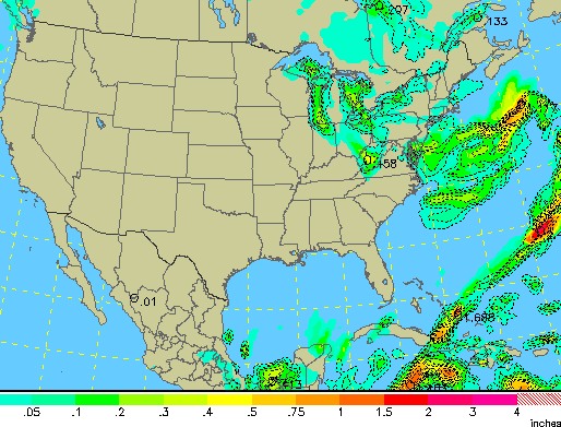
What impresses me the most right now is the intensity of the GFS' depiction of the lake effect/upslope band after midnight tomorrow over the northern half of the state:
GFS precip forecast for 2AM Tuesday morning
That would mean some heavy snowfall rates over Clarksburg/Fairmont/Morgantown, and I wouldn't be surprised to even see reports of thundersnow if that comes to pass. Again, if that happens as shown, I can't see Charleston avoiding accumulating snow altogether, as there should be a large upslope snow shield going all the way down into Kentucky. One thing is for sure, it's going to be nuts in the central and northern WV mountains including Snowshoe, Canaan Valley and Elkins, areas that could see a foot by Tuesday night.
* * *
Update 12:50PM Sunday: Some disagreement exists between the GFS and WRF/NAM models for Tuesday's event (storm #2 in this system's sequence). The GFS maintains snow over most of the state, while the WRF/NAM limits all precip to northern and eastern WV, where the main lake effect/upslope band is forecast to set up. The WRF/NAM has even put Beckley mostly out of storm #2. What both models seem to agree on is that storm #2 may start earlier than we thought, more an overnight Monday night event rather than a Tuesday one. If the WRF/NAM is correct, Charleston may get bypassed by this storm altogether, with Clarksburg/Morgantown bearing its brunt. If that ends up being the case, I'll likely head north to at least Clarksburg.
WRF/NAM (left) and GFS (right) precip forecast for Tuesday morning
In the 5 years I have been covering winter weather, I have only had to make two trips north of the Charleston area to 'intercept' a snow event in West Virginia, both in 2005 - one in Weston on October 24, and the second in Parkersburg on December 19 of that year. 99% of the time, Beckley (in the higher elevations to the east) is the most convenient bet for good snow, but occasionally localized upslope banding can set up either to the south or to the north of Charleston in the lower elevations. The only time I've gone south for a WV upslope snow band was in Hamlin in Lincoln County on March 22, 2004.
Nonetheless, I think the chances for Charleston to totally avoid any subfreezing precip through storm #2 are pretty slim. For that reason, I'm planning on staying here unless it becomes evident that we'll miss out altogether.
As for storms #3 and #4 - The GFS has been steadily maintaining the small upslope event on Thursday (storm #3). Timing will be the main issue with this one as far as any sticking snow. If it comes through at night, the chances for accumulating snow are better for all areas. Storm #4 has re-emerged on the GFS, but as a cold frontal/upslope pattern rather than the original clipper. I even hesitate to call it storm #4 at this point as it will be associated with a slightly different large-scale system than the one affecting us now. Either way, it's too far out in time to make a call on it, so I won't speculate too much on it.
* * *
Update 8:12AM Sunday: The changeover is complete in Charleston with intermittent snow showers. With our temps already reaching their likely minimum for today (and already rising slowly), the flakes will melt on contact with the ground. WVDOT indicates icy roads exist above 2000 feet, in the usual spots along Route 19, I-64 and I-77 around Beckley and Lewisburg. I don't expect any problems here in the lower elevations today. I'm awaiting reports from the mountains for accumulation totals from storm #1. I wouldn't be surprised to hear about up to 2 inches above 3000 feet and even more at the highest locations above 4000ft (including Snowshoe).
We'll see a lull in activity later this afternoon and evening as storm #1 draws to a close, but the models want to start bringing some precip through here early tomorrow morning before storm #2 gets going later Monday.
* * *
Update 6:11AM Sunday: Just had a narrow band pass through town with about a 90 percent snow mix. Temps downtown were at 35 degrees, only four away from allowing the snow to stick. A light accumulation built up on parked cars, but it quickly melted once the band passed. Beckley is at 30°F and likely has a good dusting on the ground. Upslope is only setting off random snow showers and narrow bands at this point rather than a big snow shield, so I think storm #1 may be winding down to be a non-event for the lower elevations (as expected).
* * *
Update 11:25PM Saturday: Storm #1's upslope precip pattern is in full swing now, from central WV all the way down into eastern Kentucky. Radar shows the distinct echoes nicely as the flow slams head-on into the mountains. Beckley is already at 32°F and should have no problem dropping below that soon, allowing snow to begin to accumulate. Still all rain here in Charleston, no snow mixing in just yet. We'll likely change over here in the next few hours, though I don't think we'll make it close to 32 for anything to stick.
* * *
Update 8:49PM Saturday: Storm #1 is getting under way. While the overall precip echoes on radar associated with the cold front have quickly diminished, it does appear that some upslope precip is starting to emerge. Beckley and Bluefield are currently reporting snow, with Beckley already down to 34°F. Both the RUC and WRF/NAM hint at the possibility of Charleston dropping below the 35°F isotherm (the line on the temperature map for 35 degrees), possibly approaching freezing overnight. However, QPF (precip) on both models is pretty meager after 2AM tonight. So, I don't think Charleston and the lower elevations are in much danger of icy roads until the second storm arrives Monday night.
I'm on the fence right now about going up to Beckley. It's not cold enough for anything to stick up there yet, with the exception of Flat Top and Sandstone mountains which may already be covered with a dusting. The WVDOT is reporting that I-64 has slush east of Beckley in the higher terrain - which would indicate Sandstone mountain is probably below freezing already. The latter two spots are not well-lit at night, though - and there would not be much to see there until daybreak.
* * *
Update 3:05PM Saturday: Here is a RUC image of the current trough affecting the eastern US, showing the size and strength of the system. This will be the main player in our upcoming pattern. The leading edge of this contributed to a deadly tornado event in eastern NC last night.
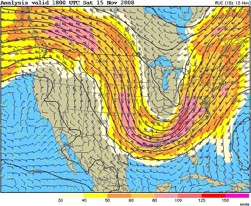
RUC depiction of 500mb wind pattern
* * *
Update 1:18PM Saturday: Current surface obs are already reporting snow in western Ohio as the cold air rushes toward us. Dayton is already at 33°F! That means quite a drop is in store for us here in Charleston tonight, currently at 56°F. The cold front is still west of the border, but knocking at the door (notice it's already passed JKL - Jackson, Kentucky). It will arrive (not very quietly) sometime this afternoon.
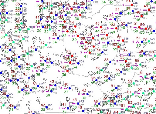
Surface obs at 1:22PM EST Saturday
Not much has changed today regarding the thinking on storms #1, #2 and #3 (see original post below), however the GFS has completely flip-flopped the past 2 runs on storm #4 - which has all but vanished on the model's output. Knowing the GFS, we may see that storm re-appear and re-vanish a few times before the model can get a better handle on things. For now we'll just need to wait for either some run-to-run consistency and/or for the storm to show up on the WRF/NAM horizon in a few days. Monday night-Tuesday morning still looks good for Charleston's first snow cover.
* * *
First update 9:07PM Friday: Well, here we go with winter season 2008-2009, already ramping up big time. Though I'm still waiting on the 00z GFS run later tonight, I think the agreement so far of the GFS, ECMWF and WRF/NAM on the large, strong upper trough on its way toward us warrants getting this dedicated post started. This is looking to be quite an event for our area, with at least four distinct episodes of accumulating snow indicated by the models, at least two of which should affect even the lower elevations (including Charleston, Huntington and Parkersburg).
This is a full-fledged winter pattern setting up, and it will feel like January starting on Sunday morning and stay that way for at least a week. I see at least four main snow events with this system - the first being Sunday morning; the second from Monday night through Tuesday night; another on Thursday, and possibly the biggest on Friday night-Saturday. In between those, cold air and moisture will be hanging around, making unexpected bursts of snow showers an ever-present possiblility. I think the chance for Charleston to have snow on the ground at least once in the next 7-8 days is near 100%, that's not too much of a limb to go out on.
Take a look at the METAR mosaic and notice the northwesterly winds behind the cold front already pulling the cold air southeastward. This is a major 'cold air' conveyor belt establishing itself that will be in place through as late as next Sunday.
Surface obs at 8:45PM EST Friday
Since we're talking about four snow events, I'm going to give attention to each one from a forecast standpoint.
Storm #1: Saturday night 15th-Sunday evening 16th
The first snowstorm in the sequence will be mainly an upslope mountain event starting Saturday night and getting into full swing by morning. Models agree for now on Charleston/lower elevations remaining above freezing through this one (in the upper 30s), but rain will likely mix in with or change completely to snow by Sunday morning (though it won't stick). The mountains dip below freezing, though - and GFS model accumulation estimates are 2 inches for Beckley (above 2500 feet) and 4-6 inches for 3000ft and above by Sunday afternoon.
Storm #2: Monday night 17th-Wednesday morning 19th
The second snowstorm in the forecast sequence will be a much stronger upslope setup starting Monday night, peaking Tuesday, and continuing into Wednesday morning. Models indicate Charleston and lower elevations seeing 2 inches or more from this round, though our temps will play a big role on how much accumulation we see. The mountains could see 4 to 8 inches from storm #2.
Storm #3: Thursday 20th
The third snowstorm in the forecast sequence is shown as another upslope event on Thursday. The GFS has backed off of the intensity of this a little, but cold air would allow any snow to stick - giving all areas in the state another shot at accumulations. The QPF (precip totals) fields on the GFS suggest just a dusting in Charleston and lower elevations, with 2 to 5 inches in the mountains.
Storm #4: Friday night 21st-Saturday 22nd
The fourth snowstorm in the forecast sequence is shown as more of a clipper-type system arriving on Friday night into Saturday morning. The GFS shows plenty of cold air and lots of QPF, suggesting a 2 to 3 inch plus event for Charleston and lower elevations and more for the mountains. It's really somewhat pointless to try to nail down something this far out in time, so my assesment of this last storm is merely assuming that the GFS could be correct.
An although it's a virtual no-brainer, this is worth a mention:
Dan!
Excellent discussion. I haven't gotten through the models today yet but basically I would agree with the first half of your setup going through Tuesday. I'm very wary of the flip flops of the GFS though looking out toward next weekend. 2 days ago the GFS had a monster storm for next Sunday and yesterday it had a high over us instead. shorter term though, I think a little Arctic-like air intruding here on Tuesday should bring a burst of snow on the nose of its arrival and as you know ratios can be crazy with light powdery snow!
Great post!!! Hope you are well!
Spencer
- Posted by Spencer from Huntington | |
Thanks Spencer! Yeah, the clipper for Saturday vanished on the 00z. I guess it will be mid-week before we can make any type of call on that one.
- Posted by Dan R. from Charleston, WV | |
Thanks for the capture Dan, tried a similar setup today on a childs portrait and got fantastic results, will always use a third (toplight) from now on !! Many thanks!!
- Posted by Mick from United Kingdom | |
|


