|
Home | Blog Index | Blog Archives | Christianity & Faith Essays | Storm Chasing Essays
Second Home: "The Open Road" - Part 4
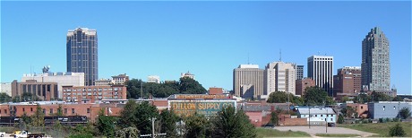
Downtown Raleigh, NC
North Carolina has always been a part of our family. Various relatives scattered around the Tar Heel state meant that a trip each summer to visit everyone was a Robinson tradition. I had great aunts in High Point, great-grandparents in Kinston, an aunt, uncle and cousins in Raleigh, and an aunt and uncle in Murfreesboro (I have just as many North Carolina roots as I do West Virginia). The usual Robinson NC trip consisted of a 2 to 3 day stop in each of those locations, followed by a trip to the coast to go to the beach, usually at Atlantic Beach/Morehead City. Occasionally, the trip would include a drive across the Chesapeake Bay Bridge-Tunnel up to the eastern shore town of Parksley, Virginia to see another great-grandmother. In retrospect, during those trips we never envisioned the significance that Raleigh would come to have for us in our futures. My brother and sister both decided to attend North Carolina State University after they graduated from high school, and both met their future (NC native) spouses there, further entrenching our family ties to Raleigh. In the midst of all this, my late grandmother purchased my brother-in-law's former house, which served as her 'second home' as well as our family's 'base' in Raleigh for many years. And even I myself have briefly entertained the possibility of moving to Raleigh - a prospect that even now, isn't entirely out of the question for the distant future.
My first trips to North Carolina were as an infant - and they are still continuing today. From those early days of my childhood until now, the familiar route from West Virginia to the North Carolina Piedmont has remained the same - but many things have changed along this route in those 30 years.
Part 4: I-77, I-74, Route 52 and I-40 from Charleston to Raleigh
View Larger Map
The route from Charleston to Raleigh includes traveling on four highways - Interstate 77 from Charleston to Mount Airy (including the WV Turnpike), Interstate 74 and Route 52 (future Interstate 74) from Mount Airy to Winston-Salem, and Interstate 40 from Winston-Salem to Raleigh. While today the entire route consists of four-lane-minimum limited-access highway, it hasn't always been that way. During the early years of my childhood, the West Virginia Turnpike was originally a two-lane road for part of its length, and the Mount Airy connection to the Route 52 highway required a few two-lane roads and intercity streets (with traffic lights) for many years. I-40 was a paltry four lanes for much of its length in those early years, compared to its mostly six, eight and ten-lane sections today. Today, the entire 318-mile journey (without stops) takes roughly five hours.
Some highlights of traveling south on I-77 from Charleston:
- Rising mountains - East of Charleston, the sharp rise in ridgetops indicates the route's plunging deep into the heart of the Appalachian mountains.
- Belle DuPont plant - Across the river from Marmet lies the huge DuPont chemical plant, intensely lit up with thousands of lights at night.
- Cabin Creek - Here, the highway sharply curves away from the Kanawha River, permanently leaving the valley to start the mountainous climb toward Beckley and the summit at Flat Top. The speed limit also drops from 70mph to 60 here as the West Virginia Turnpike officially begins. The turnpike's first toll booth is just beyond the curve.
- Cabin Creek Valley - The 60mph speed limit is well-justified through this section of very sharp curves bounded by steep mountains on either side. The jersey barriers on either side bear scars and missing chunks of concrete from the frequent accidents.
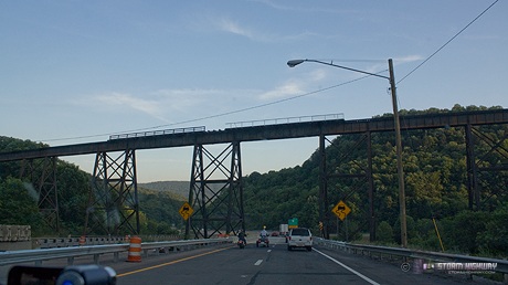
- Memorial Tunnel and cut/fill - A few miles past the Sharon exit, the highway leaves the Cabin Creek valley and climbs over a summit into the Paint Creek valley. At the crest of the hill, a massive cut marks the location of the old Memorial Tunnel, which is still visible to the west of the road. Memorial Tunnel, a two-lane bore, was in service during the Turnpike's pre-interstate years. It was abandoned after the four-lane highway was finished in 1987. Immediately after the cut is an equally massive fill across the valley, previously spanned by the Bender Bridge. The bridge was demolished when the interstate was completed, leaving the south portal of Memorial Tunnel to dead-end out of the side of the mountain. Today a narrow access road leads up to the tunnel, which is now used for Homeland Security traning excercises.
- Paint Creek Valley - The mountains are high, steep and scenic through this almost gorge-like valley, in which the interstate meanders perilously through. The abandoned right-of-way from the Paint Creek branch of the C&O railway is visible snaking along the valley along the interstate, with a few old bridges still in place. The tortuosity of the highway here contributes to another section with a high accident rate.
- Mahan - The forgotten coal mining town of Mahan lies isolated in the valley, nearly invisible to passing drivers if not for its blessing of having an exit from a busy four-lane highway nearby.
- Mossy - The highway is gaining some significant elevation by the time the road reaches Mossy. A mile or two north of the Mossy exit boasts some spectacular mountain vistas to the east. South of Mossy, the interstate enters a less-curvy plateau-like region, where the speed limit accordingly increases back to 70mph.
- Pax - The second toll booth on the turnpike demands another $1.25 from your car's coin holder and signals that you're approaching the small town of Pax. The old Virginian Railway line (now Norfolk Southern) merges in close to the highway here, roughly following alongside of it for the next five miles or so.
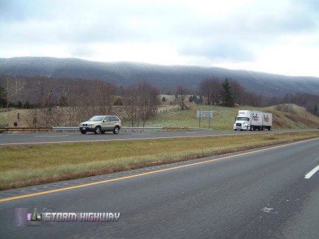
- Bradley - A couple of miles before you reach the Route 19 interchange at Bradley, the highway makes a major climb upgrade to 2500 feet and the Beckley area plateau. During the winter, this stretch of road is known for being a common rain/snow changeover point as the elevation increases.
- Tamarack - Tamarack is the round, spiked red-roofed craft shop/museum at the Beckley rest area/travel plaza. The goods here are expensive, but the food is worth stopping in for.
- Beckley - A seemingly isolated mountain urban center, Beckley is surprisingly large and bustling for a town located where it is. They've even got an Outback Steakhouse and a couple of Starbucks now.
- I-77/I-64 split - I-64 breaks off and heads east toward Richmond and Virginia Beach.
- Flat Top - Just after the third and final toll both of the turnpike, the highway crests the summit of Flat Top Mountain at over 3200 feet. Just past the summit, a sweeping view of distant mountains is visible straight ahead.
- Princeton - The last good-sized town on I-77 before the state line, Princeton is located right off of the highway and has experienced growth in recent years.
- Ingleside - A high steel bridge carries the former Virginian railway over the interstate here as the road descends into the East River valley.
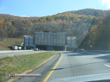
- East River Mountain - The first of two tunnels on I-77 carries the road across the state line into Virginia through East River Mountain, a classic Appalachian ridge that stretches as far as the eye can see from right to left. Although the Bluefield exit is located here, the actual town is some distance west of the highway.
- Bland - The Bastian and Bland exits lie in the valleys between the long, high ridges. A gas station at Bland competes with Wytheville's low gas prices, and its lesser traffic flow has made it my preferred stopping point.
- Big Walker Mountain - The second and final tunnel on the southbound I-77 trip.
- Wytheville - Wytheville has been a common stopping point on our North Carolina trips, mainly due to the gas prices usually being 20 to 30 cents cheaper than most other places along the way. I-77 interchanges with I-81 here. The Log Cabin restaurant downtown is a good dinner stop.
- New River Valley - The highway crosses the New River at Poplar Camp on a high, newly refurbished bridge. The 'Shot Tower' and park is visible off to the east of the road.
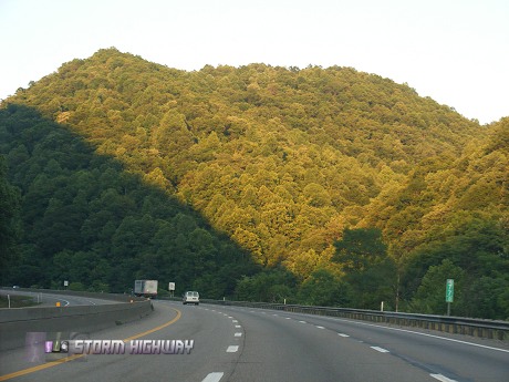
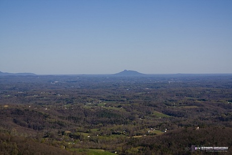
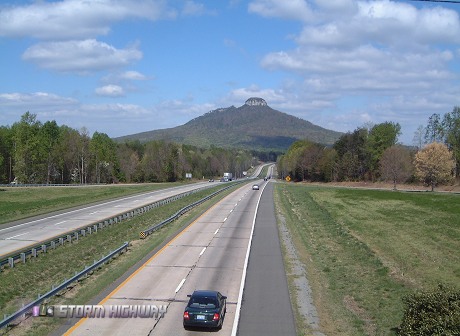
- Fancy Gap grade - I-77 leaves the Appalachians just south of the Fancy Gap exit, descending 1800 feet down the face of the eastern edge of the mountains on a steep grade. Three runaway truck ramps testify to the length and steepness of the descent. The views to the east here are spectacular, with the rolling hills of the Virginia and North Carolina Piedmont extending to the horizon. In the distance, Pilot Mountain rises from the landscape. On a clear day, even the skyline of Winston-Salem (50 miles away) is briefly visible to the left of Pilot Mountain. Unfortunately there are no places to stop to take in this view, so enjoy it during the one or two minutes that it is visible. At the base of this long grade is the North Carolina state line.
- Mount Airy - The route to Raleigh necessitates leaving I-77 here on the new I-74 connection to Route 52 at Mount Airy. Mount Airy is the hometown of Andy Griffith and the supposed inspiration for the classic TV show bearing his name.
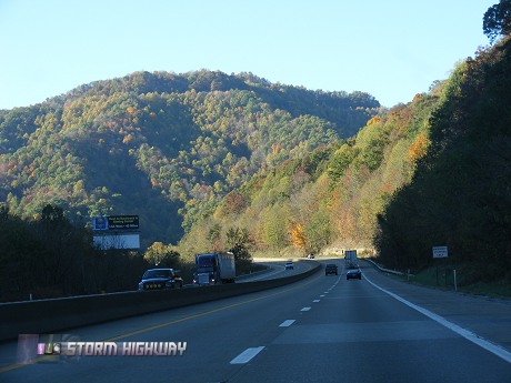
- Pilot Mountain - One of the most prominent landmarks of the entire trip is the unmistakeable Pilot Mountain, an isolated peak with a distinctive rock dome rising to 2500 feet beside Route 52.
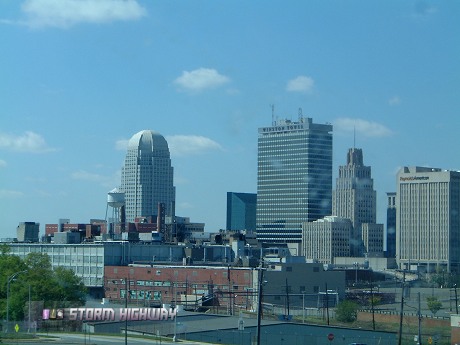
- Winston-Salem - An impressive skyline highlights this busy metro area, the first major city encountered on the trip. At downtown, the turn eastward on Business I-40 toward Raleigh is made. We've timed the Business 40 route versus continuing to the main I-40 interchange south of town, and the former route is faster by a few minutes.
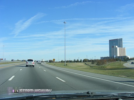
- Greensboro/High Point - Once Business I-40 joins the main I-40 near Kernersville, the highway expands to 10 lanes. From this point eastward, a fairly continuous pattern of dense urban sprawl, wide highways, businesses, hotels and factory outlet stores fill up the space on either side of I-40. The growth of this region is more than apparent, with new highways and interchanges going in in multiple spots. The Koury convention center is the tallest building along the highway between Winston-Salem and Raleigh.
- Durham - Raleigh's 'sister city' is not visible from I-40, but its suburbs stretch south across the highway.
- Raleigh metro - The trip for us ends in Raleigh, with the skyline peeking briefly above the trees along I-40.
Next road: Route 35 from Teays Valley to Dayton
|


