|
Home | Blog Index | Blog Archives | Christianity & Faith Essays | Storm Chasing Essays
Rain and first Raleigh business trip
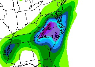
Some good news for the Appalachians and particularly the Carolinas - a soaking rain looks like a decent possibility in the next few days. Here is the HPC (Hydrometerological Prediction Center) rainfall outlook for the 24-48 hour period into Wednesday morning:
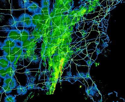
And here it comes. Look at the eastern US radar image from tonight:
Seeing those 2-inch plus bullseyes over the mountains on the HPC outlook automatically brings flash flooding to mind, but as dry as it has been in the past few months, I don't think we'll see too many flooding problems with this system. The mountain streams should be able to handle 2 inches of moderate rain spread out over the course of a day. A few isolated spots that can muster 3 inches or more, or 2 inches in a couple of hours assuming 'training' heavy rain, might see some minor flooding. So this probably won't be a system I'll go on 'chase standby' for, unless a big band of heavy rain starts setting up across West Virginia on Tuesday.
In the midst of this much-needed rain, we'll be making the first official CIS business trip to Raleigh on Wednesday and Thursday for meetings with our first prospective North Carolina clients. My three months in Raleigh this summer was doing the the prep work for this, so I'm excited to see things finally get moving.
October 18 chase log - Kentucky/Indiana
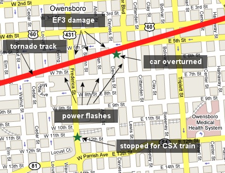
For those of you that don't keep up with my main web page or the chasing RSS feed, here is a link to the chase log for Thursday. It turns out that a few of my storms produced tornadoes hidden deep in the heavy rain, including an EF3 less than 500 yards away from me in downtown Owensboro, Kentucky. I posted quite a few photos and a couple of video clips to the log. Here is a map showing the tornado track and my position waiting for a CSX train, with the tornado passing less than three blocks away in front of me.
GO: Home | Storm Chase Logs | Photography | Extreme Weather Library | Stock Footage | Blog
Featured Weather Library Article:
|


