|
Home | Blog Index | Blog Archives | Christianity & Faith Essays | Storm Chasing Essays
Second Home: "The Open Road" - Part 1
During the past seven years, I have spent much of my life on the road, 'living the dream' of photographing storms and covering weather events as a part-time (and occasionally full-time) job. Unlike most people, I love long road trips and almost never get tired of driving. Calling the road my 'second home' would not be too far from the truth. My storm chase expeditions across the country have opened my eyes to the world outside of my home state, so much so that for the first time, the prospect of moving away became more appealing. The fact that I've started considering living in new places is largely a result of storm chasing and the 'open road' making me more comfortable with new horizons.
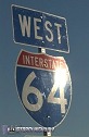
Part 1: I-64 from West Virginia to Missouri
View Larger Map
 By far, this section of I-64 has become my favorite travel highway. Since I began my photography chases to the Great Plains in May of 2001, I have made no less than 19 round trips (38 trips each way) on Interstate 64 between Charleston, West Virginia and St. Louis, Missouri. Nearly every storm chasing trip will take me either west on I-70 (to Kansas and Nebraska) or southwest on I-44 (to Oklahoma and Texas), making I-64 to St. Louis my 'gateway' to the Plains. The 506-mile leg to St. Louis takes a little over 7 and a half hours, crossing five states and a time zone boundary in the process. I look forward to the trip out west as much as I do the destination, and despite the long distance it is never tiring or boring. By far, this section of I-64 has become my favorite travel highway. Since I began my photography chases to the Great Plains in May of 2001, I have made no less than 19 round trips (38 trips each way) on Interstate 64 between Charleston, West Virginia and St. Louis, Missouri. Nearly every storm chasing trip will take me either west on I-70 (to Kansas and Nebraska) or southwest on I-44 (to Oklahoma and Texas), making I-64 to St. Louis my 'gateway' to the Plains. The 506-mile leg to St. Louis takes a little over 7 and a half hours, crossing five states and a time zone boundary in the process. I look forward to the trip out west as much as I do the destination, and despite the long distance it is never tiring or boring.
Some highlights of traveling west on I-64 from Charleston:
- Teays Valley, WV - This stretch of I-64 runs through some of the flattest topography in the state. Here I usually set my clocks to Central Time, since that's where I will be at the end of the day.
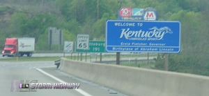
- Cattlettsburg, KY - The sight of the oil refinery on the Big Sandy marks the first state line crossing of the trip. Leaving West Virginia and entering Kentucky brings on the feeling like the journey is finally 'under way'.
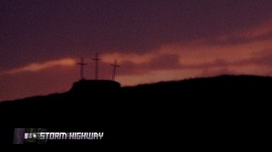
- Grayson, KY crosses - Three wooden crosses on an isolated hill near the interstate have stood the test of time, despite much of the hill being excavated away around them.
- Morehead, KY - A common place to stop for a cold drink, namely the ginger-ale-like "Ale-81".
- Owingsville, KY - Here I-64 crosses the western boundary of the Appalachian mountain topography. Between Owingsville and Mt. Sterling, the mountains abruptly end as the road breaks out into the classic rolling hills and open fields of Kentucky Bluegrass country.
- Lexington - Lexington lies in the heart of Bluegrass country, with rolling hills and open skies. Endless brown, black or white wooden horse fences stretch across vast, green fields.
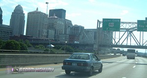
- Louisville - The first major city encountered on the trip, with the highway squeezing close in between big Ohio River road and rail bridges to the north and the downtown skyline to the south.
- New Albany, IN - The towering double-deck bridge over the Ohio marks the second state line crossing of the trip.
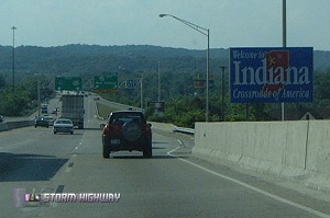
 - Indiana hills and forests - I-64 enters a hilly, forested area that covers much of southern Indiana, parts of which are within the boundaries of Hoosier National Forest. I-64 crosses the Eastern/Central Time Zone boundary here. Near the end of this region lie the towns of Jasper and Santa Claus.
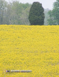
- Evansville - By the time I-64 reaches the Evansville area, the Southern Indiana hills have leveled off into flat, open fields. The interchange at Highway 41 is the designated first stop for fuel of the trip. Gas prices here tend to be the lowest of anywhere I have traveled, and the pumps are usually very busy. In the springtime, bright, photogenic yellow flowers often cover many of the fields here.
- Griffin, IN - This small town on the Wabash River floodplain was in the path of the infamous Tri-State tornado of 1925. Past Griffin, the sightings of oil and natural gas pumping jacks become more numerous, many of which have open flames burning from small stacks. Some of the pumping jacks near the Wabash river are elevated on platforms to protect against the frequent floods.
- Wabash River - The Wabash River bridge marks the third state line crossing of the trip. An old railroad bridge is to the north, with one of the spans collapsed into the water from a previous flood. If you stop at the rest area on the Illinois side, listen for the chugging of the old gas pump jack next to the parking lot.
- Southern Illinois country - Flat and sometimes swampy ground is the norm for some distance before and after Burnt Prairie. Watch out for the legions of large insects hitting your windshield at dusk through this stretch! Some of the land is so flat and treeless here that it is almost indistinguishable from the Great Plains.
- Mount Vernon, IL - A brief merger with I-57 takes place here.
- Mascoutah, IL - Mid-America airport and Scott Air Force Base, both visible to the south, are signs that St. Louis is close. Plains-like flatness abounds here also.
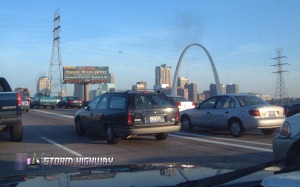
- Fairview Heights, IL - Just past this exit, the Interstate descends the bluffs down onto the Mississippi floodplain, at which point the Gateway Arch and downtown St. Louis skyline first become visible in the distance.
- Mississippi River Bridge - The 'Grand Entrance' to St. Louis, with a spectacular view of the Arch to the right.
Next road: I-44 from St. Louis to Tulsa
|


