|
Home | Blog Index | Blog Archives | Christianity & Faith Essays | Storm Chasing Essays
Second Home: "The Open Road" - Part 2
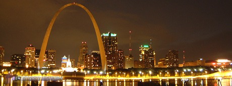
St. Louis has grown on me ever since I first passed through late one evening in May of 2001, on my way to my first Great Plains storm chase expedition. In a way, St. Louis was (and is) a symbol of my new-found freedom in the open road. It was the first new major city I had visited alone, and marked (up to that point) the longest single drive I had traveled solo. From Charleston, St. Louis is a little more than halfway to the Great Plains region, and is a landmark milestone in the trip westward. When I see the Arch, I know the open skies, big storms and new, unexplored territory of the Plains are just a few more hours away.
Part 2: I-44 from Missouri to Oklahoma
View Larger Map
 Interstate 44 has also made it high on my list of favorite highways. When the severe weather targets set up in Oklahoma and Texas, I-44 is the 'home stretch' of the trip - with St. Louis well past the halfway mark to the first Great Plains destination city of Tulsa, 395 miles and little less than 6 hours' drive away. Tulsa has become a common 'launching point' for many of my storm chase expeditions since I started, thanks in part to the hospitality of veteran chaser Dave Crowley and the members and good friends of our original chasing group who also lived in the area. Although Kansas and the I-70 route have brought many great tornado intercepts, I'm always hoping that the storms will set up south of the Kansas border - making I-44 the route inbound. Once in Tulsa, most targets in Oklahoma, northern Texas and southern Kansas are within a 4 to 7 hour drive, enough time to leave in the morning to make a late afternoon storm initiation. Interstate 44 has also made it high on my list of favorite highways. When the severe weather targets set up in Oklahoma and Texas, I-44 is the 'home stretch' of the trip - with St. Louis well past the halfway mark to the first Great Plains destination city of Tulsa, 395 miles and little less than 6 hours' drive away. Tulsa has become a common 'launching point' for many of my storm chase expeditions since I started, thanks in part to the hospitality of veteran chaser Dave Crowley and the members and good friends of our original chasing group who also lived in the area. Although Kansas and the I-70 route have brought many great tornado intercepts, I'm always hoping that the storms will set up south of the Kansas border - making I-44 the route inbound. Once in Tulsa, most targets in Oklahoma, northern Texas and southern Kansas are within a 4 to 7 hour drive, enough time to leave in the morning to make a late afternoon storm initiation.
Some highlights of traveling west on I-44 from St. Louis:
- Downtown St. Louis - As soon as I-64 crosses the Mississippi into downtown St. Louis, the first exit ramp begins the jump over to I-44 along a brief section of I-55, passing next to Busch Stadium in the process.
- Maplewood, MO - A strange landmark in the form of two mysterious towering, cylindrical trusses is located in this St. Louis suburb. From the info I can gather, these are abandoned natural gas storage tanks called 'gasometers' with telescoping expandability.
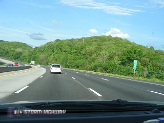
- Ozark mountain terrain - Traveling westward, one can see the topography on I-44 west of the Mississippi is in stark contrast to the flat prairie-like land along I-64 in southern Illinois. I-44 plunges into Ozark country for much of its journey across southern Missouri, with rolling hills punctuated by a few deep valleys and high ridges. The first major hill is enountered west of the I-270 beltline interchange. While not as rugged as the Appalachians, a few spots in the Ozarks are reminiscent of West Virginia scenes.
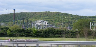
- Allenton - The roller coasters of the Six Flags amusement park, located just north of the highway, are visible here.
- Route 66 - The entire length of I-44 between St. Louis and Tulsa follows the alignment of the historic Route 66 highway. In some places, the original Route 66 parallels the interstate as a frontage road, in other spots the interstate replaces it altogether.
- Jerome/Newburg - The highway descends into one of the deepest valleys on this section of the route. The eastern grade of the descent was recently re-routed to form a much straighter alignment.
- Tourist traps - Numerous repeating billboards relentlessly advertise the area's popular caves, an outdoor wild animal exhibition, and Branson's shows and attractions.
- Springfield - Second to St. Louis, Springfield is the largest city served by I-44 in southern Missouri. Billboards for nearby Branson (a Vegas-like tourist destination) clutter the highway.
- Karst topography - As I-44 exits the Ozarks, the rolling hills reveal the Karst topography common from near Springfield to around the Oklahoma state line. Every so often, large light-colored boulders and rocks jut from the grassy fields and embankments along the highway.
- Joplin - The last major city on I-44 before the Oklahoma state line. The Joplin-Springfield area is the common overnight stopover point for many of my Plains storm chasing trips, with the usual arrival time there between 1 and 3 AM. Many times my overnight stays (if I'm by myself) are in my car, at either one of the two rest areas or any secluded, quiet place I can find. I don't do this as much as I used to, but 'car lodging' was and is symbolic of the new freedom I was enjoying on the road - the cost savings from hotel stays is what financially enabled me to make many of those first trips to the Plains.
- Baxter Springs/Galena, KS - The site of the last exit on I-44 in Missouri before the Oklahoma state line. The exit is labeled for Kansas towns, because they are closer than the nearest Missouri or Oklahoma town. The 'triple-point' of Kansas, Missouri and Oklahoma is located within a few hundred yards of here. If you're so inclined, you can take the exit and drive a couple of minutes to the point (on a dirt road) where all three states meet. The Baxter Springs exit is also the last chance to stop before entering the tolled Will Rogers Turnpike section of I-44.
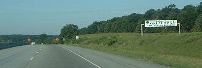
- Oklahoma state line - When you first enter Oklahoma, the terrain doesn't immediately announce that you're entering the Great Plains region. However, that gradually changes during the next 20 miles as you move westward.
- Northeastern Oklahoma country - Exits are few and far between here - come to think of it, paved roads are scarce too - with the occasional dirt road crossing over the highway on concrete overpasses. The land flattens out dramatically by Miami, though the gently rolling hills are not quite as flat as you would expect. In fact, a newcomer to these areas will discover that large portions of the Plains states are not flat at all, particularly the eastern ends of Kansas, Texas and Oklahoma.
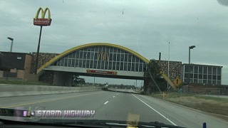
- Vinita - The rest area near Vinita boasts the claim to the largest McDonald's restaurant in the world, built across all four lanes of the highway.
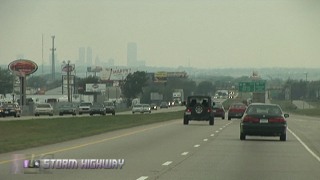
- Tulsa - The trip to the Plains is complete! From here it's westward on any number of potential routes to wherever the severe weather patterns set up.
Next road: I-79 from Charleston to Washington
|


