| Home | Blog Index | Blog Archives | Christianity & Faith Essays | Storm Chasing Essays
2009-2010 US icy road season begins
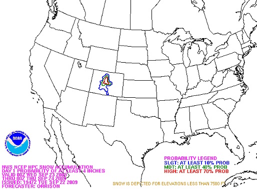
It's that time of year - the signs of winter are on the horizon. Snow and subfreezing temperatures have arrived in Colorado's Rocky Mountains, typically one of the first parts of the lower 48 US states to see the arrival of winter weather in the fall. Snow actually began in the Rockies on Monday (the last day of summer) and some areas may see up to a foot of snow Wednesday. Though no accidents have been officially reported, many Rocky mountain roads have been closed due to ice, and transportation officials have cited icy spots on the high-elevation sections of Interstate 70. It goes without saying that the first minor ice-related accidents of the season are likely in progress in the mountains of Colorado, and the threat may even extend into the Denver metro area. The HPC has resumed its winter weather forecast graphics for the season, with Colorado showing up prominently in Wednesday's outlook:

HPC snow Outlook for Wednesday
You'll be seeing a lot more talk about icy roads here and at icyroadsafety.com, where a site redesign and a PR campaign is in the works. The road ice hazard will, if all goes as planned, be at least a part-time job for me until the last snows of the season wrap up in late April. With that, my annual late-summer 'weather lull' will come to a close. It's back to several-times-daily forecasting excercises, model watching and of course, back to trudging out into the elements to cover the events. Winter has become my most active season, and I expect this year to follow that pattern!
What happened to the other "seasons"?
This late-summer/fall period has turned out to be just as quiet as the spring tornado season. The 2009 Atlantic hurricane season is all but done, and conditions don't look favorable for any development through the rest of the traditionally-favored part of the period (US hurricane season ends November 1, but October is not a prolific time for tropical systems).
The fall Midwest/Ohio Valley severe weather prospects are still in play, though, and will be until late November. West Virginia, Kentucky and Ohio could see a round or two of severe storms on Friday and Saturday, but at this stage it doesn't look like a major event. Something I'll be on standby for, but the probability of a long-distance chase is low right now.
|