|
Home | Blog Index | Blog Archives | Christianity & Faith Essays | Storm Chasing Essays
Second Home: "The Open Road" - Part 3
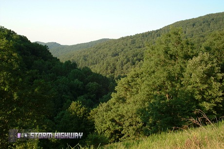
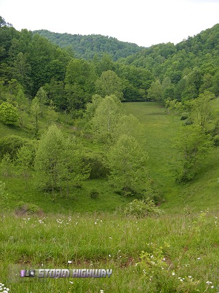
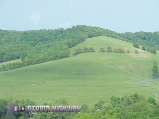
Classic Interstate 79 scenery near Frametown, WV
Of all the roads in the country, no highway is more familiar to our family than Interstate 79. Counting trips by me, my parents, brother and sister collectively, this stretch of road has been traveled by us literally hundreds of times during the last 25 years. I was 7 years old when I first made the trip, as my family and I moved from Charleston, West Virginia to Washington, Pennsylvania in 1982. With my grandparents still in Charleston, each year saw us making at least 4 round trips down I-79. Even as a kid, I had all of its exits and landmarks memorized - even to the point of compiling a crude 'traveler's guide' for the route. Every childhood memory of mine from Christmases, Thanksgivings and summer vacations past involve this highway, making it so familiar that I never feel like I'm traveling as I'm driving on it. Today, Interstate 79 still plays an integral role in our family's transportation routes, and probably will for decades to come.
Part 3: I-79 from West Virginia to Pennsylvania
View Larger Map
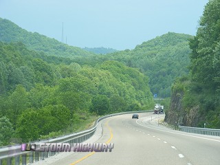
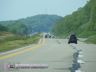
 Interstate 79 in West Virginia follows the western side of the Appalachian Mountains northeastward from Charleston, staying mostly in the rugged and scenic foothills to the west of the higher terrain. The topography along the route means there are very few flat and straight sections, however the mostly mild curves are still comfortably negotiable at the 70mph speed limit. While the highway travels in a general north-northeasterly direction, the winding route occasionally turns east and even southeast in spots. The road meanders through a landscape comprised of tree-covered mountains and hills, fully green in the summer, brown in the winter and spectacular with colors in the fall. While much of the route is in remote rural country, the I-79 traveler is never far from the neccessities of the road - with food and gas stations located near most of the exits. Interstate 79 in West Virginia follows the western side of the Appalachian Mountains northeastward from Charleston, staying mostly in the rugged and scenic foothills to the west of the higher terrain. The topography along the route means there are very few flat and straight sections, however the mostly mild curves are still comfortably negotiable at the 70mph speed limit. While the highway travels in a general north-northeasterly direction, the winding route occasionally turns east and even southeast in spots. The road meanders through a landscape comprised of tree-covered mountains and hills, fully green in the summer, brown in the winter and spectacular with colors in the fall. While much of the route is in remote rural country, the I-79 traveler is never far from the neccessities of the road - with food and gas stations located near most of the exits.
Some highlights of traveling north on I-79 from Charleston:
- Airport approach light superstructure - We used to call this unusual structure the 'airplane bridge': a series of guyed towers joined by a continuous truss at the top. The structure, visible from I-79 at Mink Shoals, carries the approach lights across a deep valley at the north end of the main runway at Yeager Airport. Since Charleston's airport is built on top of a mountain, with steep dropoffs at the ends of the runways - the tower structure is the only way to allow the approach lights to be installed on a level grade with the main runway. The structure runs through the heart of Charleston's Coonskin Park.
- Elkview - The small community has seen a recent explosion of development at the I-79 interchange, with hotels, restaurants and grocery stores.
- Elk River - The Elk River loosely parallels I-79 from Charleston to Flatwoods, crossing under the highway at Frametown and Sutton. The river is a short drive east from the exits at Elkview and Clendenin.
- Amma - Sandy Brae golf course is part of a nice scenic view looking eastward.
- Wallback - Your sense of direction will be challenged approaching Wallback, as the highway turns east and then southeastward before the exit, then more than 90 degrees back to the northeast past the exit. In November, cars and trucks will be parked off of the highway as hunters take to the woods for deer season.
- Frametown/Route 19 - The junction with Route 19 takes place just north of here, near the summit of one of the higher grades of the highway. Route 19 has become a major north-south artery itself, after being expanded to four lanes all the way to Beckley. This has made it a preferred connection for travelers coming north on I-77 from the southeastern US states. As a result, the traffic flow on I-79 will often increase abruptly at the Route 19 interchange northward.
- Sutton - The final crossing of the Elk River takes place here as the highway takes a more permanent turn toward the north. An impressive concrete dam holding back Sutton Lake is located a few miles east of the exit, but is not visible from the interstate itself.
- Flatwoods - Located in a bowl-like valley, Flatwoods is another area that has seen development in recent years with the addition of a factory outlet mall.
- Burnsville - The town of Burnsville lies deep in the Oil Creek/Salt Lick Creek valley. This exit has the distinction of being exit #79, at milepost 79, on Interstate 79, a fact the "79er" family restaurant takes advantage of. Another major grade is located past the Burnsville exit, carrying the highway to a scenic series of ridgetops.
- Weston - Route 33 (Corridor H), another recently four-lane-expanded highway to the east, interchanges here. Weston marks the halfway point between Charleston and Washington, PA.
- Lost Creek - An abandoned railway grade follows the highway here, crossing an old wooden trestle at one point. The rail line was active as recently as the early 90s, serving a now-shut down coal mine near Jane Lew.
- Clarksburg - Next to Charleston, Clarksburg/Bridgeport is the largest urban area in West Virginia served by I-79. A large selection of restaurants make it a common stop for lunch or dinner on the way. Past the main Clarksburg exit, look for the B&O railroad tunnel to the west of the highway - for a split second, you can see all the way through it.
- Shinnston - A new FBI facility is located at the brand-new Jerry Dove Drive interchange here.
- Tygart River - The highway crosses the Tygart on a high bridge here. Look east for the tall railroad bridge across the river.
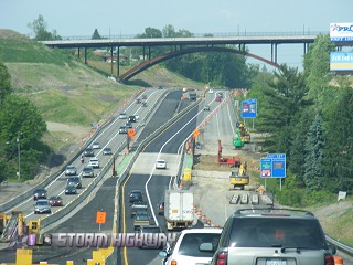
- Fairmont - Another respectable urban center that has been seeing quite a bit of construction on I-79, including a new interchange and arch bridge across the highway.
- Monongahela River - Just past the interchange with I-68, the interstate crosses the highest and longest bridge of the route over the Monongahela River Valley.
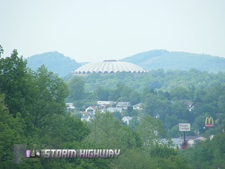
- Morgantown - While descending another long grade before the first of three Morgantown exits, the distinctive dome of the West Virginia University's basketball coliseum is visible in the distance.
- Osage - On the right of the highway just past the Star City exit, an abandoned coal mine entrance is visible. At one time, electrified tracks were installed here, but were recently removed.
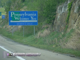
- Mount Morris/Pennsylvania state line - One of the few state lines where the change in highway maintenance practices is evident, with West Virginia surprisingly having the smoother roads of the two.
- Kirby 'railroad pipes' - Railroad tracks pass under the roadways here via huge corrugated steel pipes.
- Southwestern Pennsylvania terrain - While the hills seem to become only slightly less rugged here, Pennsylvania's hills have much more open fields and meadows than trees compared to West Virginia. The result is some nice scenic views in spots whenever the highway rises in elevation.
- Waynesburg - The seat of Greene County, with an airport beacon located on top of a hill rather than on top of the control tower.
- Ruff Creek mine subsidence - Underground longwall coal mining is common in this part of the state, where large machines remove the coal seams and allow the rock to collapse behind it. The result is corridors of surface subsidence that visibly affect the roadway, the most dramatic of which can be seen after the Ruff Creek exit. On this straight stretch, several dips in the road from the collapse of underground mines are evident.
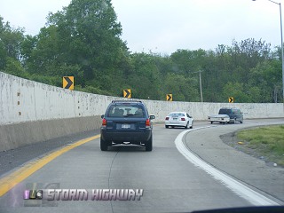
- Laboratory/I-70 interchange - I-79 'multiplexes' (shares) a stretch of highway with I-70 through part of Washington, starting with an interchange just past the town of Laboratory. Northbound I-79 traffic must negotiate one of the sharpest curves on the interstate system here - nicknamed 'The Dangerous Curve' by us as kids due to the numerous accidents that happen here. The huge concrete wall on the outside of the curve bears the scars of frequent vehicles crashing and scraping along it.
- Washington - The Beau Street exit is the the northern terminus of the typical Robinson family trip on I-79.
Next road: I-77 and I-40 from Charleston to Raleigh
|


