| Home | Blog Index | Blog Archives | Christianity & Faith Essays | Storm Chasing Essays
The earthquake hazard in the US - data and links
Of increasing interest to me over the years has been the hazard of earthquakes in the United States. I've posted about this subject a few times before, and last week's eastern US event that caused widespread damage across the mid-Atlantic warrants a revival of the topic. Getting a feel for the history of seismicity in this country reveals that earthquakes are probably one of the greater long-term hazards we face, in terms of the potential for a single event to create a disaster surpassing any atmospheric threat - and that in places that are nearly completely unprepared for it. This is nothing new, of course - earthquakes have been happening all over the USA as long as the continent has existed.
Earthquakes - from small ones to larger ones able to be felt and cause damage - occur in every US state [1]. While the vast majority of earthquakes happen at the classic and well-known tectonic plate boundaries, intraplate quakes can and do happen anywhere on earth along countless deeply-buried faults (both known and unknown). Significant quakes (above magnitude 6.0) have historically struck areas not widely known for their seismic hazard, and will happen again. Because these larger events occur on a timescale too large to remain in the forefront of the public mind, they go largely unrecognized until an event like the 2011 Mineral, VA quake 'awakens' awareness.
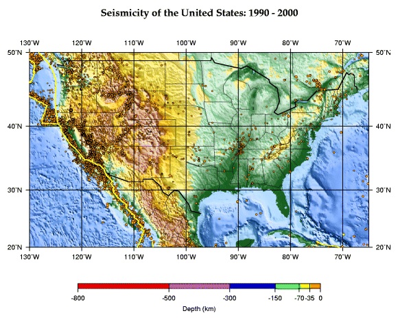
Earthquakes in the US since 1990 (USGS)
Nearly every US state has had at least one quake above magnitude 5.0 within the past 150 years. (For a list of the largest quakes in each US state, see this table.) Here are just a few examples of major earthquakes (magnitude 6.0 and above) that have struck areas in the US outside of California and Alaska [2]:
- Hebgen Lake, Montana - August 18, 1959; Magnitude 7.3
- Cascadia subduction zone (Washington and Oregon) - ~1700; Magnitude 9*
- Charleston, South Carolina - September 9, 1886; Magnitude 7.3
- New Madrid, Missouri - December 1811 to February 1812; Four events from Magnitude 7 to 8
- Borah Peak, Idaho - October 28, 1983; Magnitude 7.0
- Pleasant Valley, Nevada - October 3, 1915; Magnitude 7.1
- Denver, Colorado - November 8, 1882; Magnitude 6.6
(* the Cascadia subduction zone is capable of producing an earthquake/tsunami event similar to the March 2011 Japan disaster).
Keep in mind that these earthquakes, particularly the ones along and east of the Rockies, have caused shaking and damage across great distances on the order of over a thousand miles away, in places that the public has no realization that such a hazard exists. West Virginia, for instance, despite having no large earthquake epicenters (above M5.0) within the state in recorded history, has nonetheless felt strong shaking from quakes originating in nearby states (as in the case of the 2011 Mineral, VA event).
It's good to see that in some places like the New Madrid seismic zone, preparedness and awareness levels have been slowly increasing over the years. Earthquake-resistant structural retrofitting of highway bridge and overpass supports in St. Louis, for instance, are examples of money being spent to take the threat more seriously. However, in places such as the east coast where the magnitude 7.0+ quake may be a once-per century event, the potential for great tragedy and losses remain.
Here are some good links to interesting reading on the earthquake hazard, along with some video clips:
[1], [2] - Source: USGS
Very interesting links! Can't wait to go through all of them, especially since I'm an Earth Science major. In regards to the Cascadia subduction zone, it is actually due for a major quake. The last "megaquake" there was in 1700, and it created a tsunami that traveled all the way to Japan, where it was documented. Geologic history in that region shows that there is a megaquake about every 300 years. From what I've heard, people in the Pacific northwest are even more ignorant/unprepared than those of us in the Midwest, though they are getting better about it (tsunami drills along the coast, for example).
- Posted by Sarah from St. Louis | | |
|


