| Home | Blog Index | Blog Archives | Christianity & Faith Essays | Storm Chasing Essays
2012 storm season blog kickoff; Friday outbreak forecast
It's that time of year again: Can you believe we've made it through another winter? Yes, spring severe weather season 2012 has finally arrived! March 1 - the beginning of meteorological spring - has and always will be a celebrated date on the calendar for me and most storm chasers alike. In the coming weeks, winter patterns will become fading memories as we begin the welcome warm-ups, the first greening of trees/grass, and most of all, great storms. While the Midwestern USA's severe weather season never truly ends (as we've seen quite evidently this January and February), it is the spring months that provide the long-awaited peak season for photogenic supercells and tornadoes that storm chasers everywhere wait for.
While the month of March itself is typically just a warm-up period for severe weather events, it's certainly a time to pay closer attention to upcoming patterns and be more prepared to chase. Climatologically speaking, many classic tornado events have occured during March across the Plains and Midwest. And indeed, most years I've embarked on at least one or two major storm chase days through the course of the month. We will almost certainly have several powerful upper level troughs plowing across the nation's midsection in the coming weeks. If good moisture can make it northward ahead of those troughs, it'll mean simply, "storm chase day". March is simply the opening act for when the heart of the season arrives on April 1, with the onset of more consistent deep moisture at the surface available for when the upper troughs swing through.
Meteorological spring starts with an outbreak
In dramatic fashion and as if right on cue, meteorological spring 2012 is making itself known by severe weather outbreaks - one yesterday (a day early on February 29) and tomorrow, Friday March 2. Friday's event has the potential to be a major outbreak of tornadoes across the lower Midwest and South, including Illinois, Indiana, Arkansas, Missouri, Kentucky, Tennesee and Ohio. Let's take a quick look the NAM forecast sounding for noon in St. Louis:
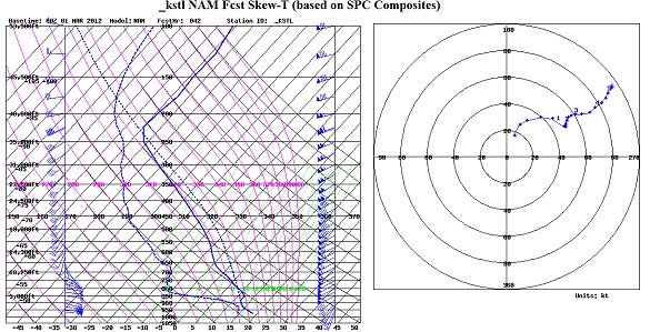
42-hour NAM sounding in KSTL for noon (18z) Friday
Aloft, a very powerful jet in the mid and upper levels will be screaming into the region, with 500mb winds in excess of 100 knots (115mph). At the surface, a low pressure system will be rapidly deepening in response to the jet overhead, with strong southerly winds in its southeast quadrant pulling large amounts of Gulf moisture into the region - shown now topping 60°F in central IL, somewhat abnormally high for such an early spring setup at these latitudes. Finally, precipitation - in the form of thunderstorms - is shown in progress already by midday in and around St. Louis and northward. As the afternoon progresses, the cold front should light up with numerous storms down into the mid-South, all of which will race northeastward through the night. This should easily end up being a multi-state Moderate Risk area, and a large one at that. I would not be surprised to see an upgrade to High Risk if more instability can be realized across the threat area.
With such screaming winds aloft, thunderstorms will be rocketing northeastward as fast as 60 to 70mph, making this chase one of the 'cell hopping' strategy, positioning along an east-west road to watch multiple storms as they pass by rather than picking one storm to latch onto. Staying with any one storm will be near-impossible and very dangerous (due to the unsafe vehicle speeds a storm chaser would need to attempt to keep up - remember, car accidents are the real danger in storm chasing!).
This is certainly a day for the general public to keep an eye out for and be prepared. Stay tuned to this web site for updates and possibly live streaming video during the chase.
|


