| Home | Blog Index | Blog Archives | Christianity & Faith Essays | Storm Chasing Essays
Identifying tornadoes and funnels in the Midwest
Tornadoes and funnels can happen anywhere the conditions come together. However, the Midwest region sees, on average, a higher number of of these events than anywhere else (outside of the Great Plains and waterspout hotspots in the tropics, of course). That being said, Midwestern storms can produce a multitude of cloud features that look like tornadoes and funnels, and it can sometimes be difficult to positively identify one. This post is meant to be a guide to assist the Midwestern spotter and chaser in identifying these features.
Funnel-like cloud features are common in storms, and it is more likely for any given one to not be a funnel. As such, the designation should be made conservatively and only after careful scrutiny. One main principle to keep in mind that shape alone is not sufficient evidence to designate a feature as a funnel or tornado. There are two key requirements to classify a feature as a legitimate funnel or tornado:
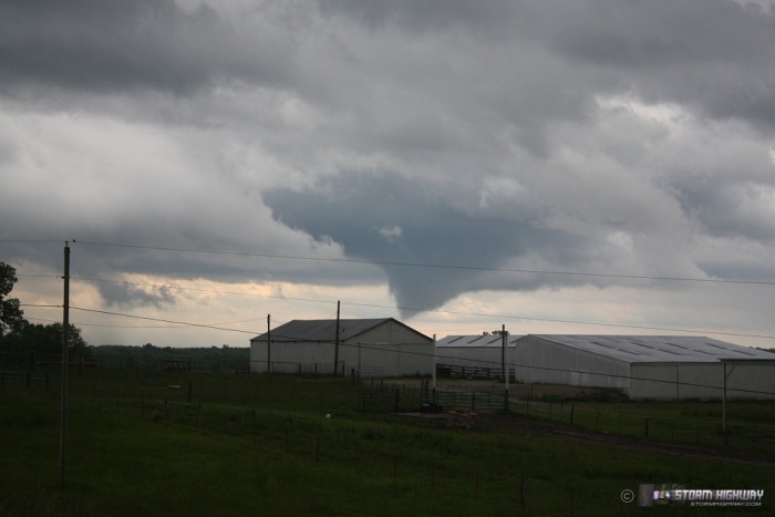
- Located in an updraft region: Funnels form when a persistent updraft stretches an area of 'spin' in the air. For that to happen, there must be a strong, broad, persistent area of upward-moving air.
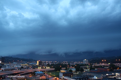
Updrafts are identified by rising motion in cloud material in a broad storm base. This is tricky, because rising motion is also seen along gust front shelf clouds. Typically the rising motion seen along a shelf cloud is in a very narrow zone ahead of the gust front, a result of the gust front plowing forward and lifting the air ahead of it. Though it's not impossible for a legit funnel to be located under a shelf cloud, it is quite rare. Funnel-like features in shelf clouds should almost always be dismissed as non-tornadic unless there is strong evidence to suggest otherwise (like rapid rotation and a debris cloud).
You can also discern if a nearby base is part of an updraft by chasing wind/cloud movement around the storm. An updraft will have wind (and low-level cloud material) blowing into it rather than away from it. If you're facing the storm, an updraft should result in the wind being at your back, flowing into the storm. If the wind is blowing outward away from the storm, you're chasing outflow - and it's unlikely that any feature in front of you will be a funnel or tornado. Outflow regions of a storm are often cold enough for lots of low-hanging clouds to condense, many of which can appear to be funnels or tornadoes. These are almost always tornado/funnel look-alikes, not the real thing.
- Rapid motion: The second and most critical characteristic of a funnel or tornado is persistent, rapid motion. This is almost always in the form of rotation, but some tornadoes in the Midwest can have a more rapid upward motion component than rotation (see the Geff, Illinois, Saint Francisville, Illinois and Sedalia, Missouri tornadoes). Tornadic motion is very fast, unmistakeable and obvious to the chaser. A tornado's motion is never stationary or 'lazy' in appearance. A cloud feature that is lacking in rapid upward motion or rotation is not a tornado/funnel, no matter how much it is shaped like one.
Turbulent motion can be present in storm clouds that may appear to be rotating, particularly along and under gust fronts/shelf clouds. The key to distinguishing an area of turbulent motion vs potentially tornadic rotation is where it is located: is it under an updraft (inflow region) or outflow? If it's located in outflow moving away from a storm, it's almost never tornadic.
It can be difficult to see rotation in a feature viewed at a great distance away, even if it is indeed a true funnel. Far-away tornadoes/funnels should only be called as such if they have a well-defined and long-lasting laminar (smooth edged) funnel shape and/or a visible debris cloud. For me personally, I would hesitate to 'count' anything as a definite tornado or funnel viewed at more than a few miles away unless it was unmistakeable.
As a general rule, one should be highly conservative in calling a feature a funnel or tornado. I almost always first assume something I see is not tornadic unless it gives me a very good reason to suspect otherwise. From a spotter perspective, my opinion is that most damaging/life threatening vortices that warrant urgent calls to the NWS for warnings will almost always be very obvious (strong rotation/motion in a persistent updraft). I have never seen a questionable feature that went on to be a strong tornado. The strongest and most dangerous tornadoes I've seen, without exception, have occurred in very obvious fashion.
For every legitimate tornado or funnel I see in the Midwest, there are dozens of look-alikes. It can be hard to tell sometimes - in those cases, I'll usually dismiss the feature, or at best, say that it's inconclusive. The real tornadoes are almost always easy to say "no doubt about it".
"Shear" funnels: Non-tornadic "shear" or "horseshoe" funnels can indeed occur outside of an updraft environment, and would be an exception to rule #1 above. Again, since many cloud and storm features can have a funnel-like appearance, the key defining characteristic is rotation. If it's not rotating, it's not a funnel, even if it has a convincing laminar (smooth edged) appearance.
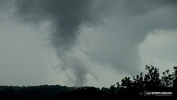
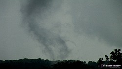
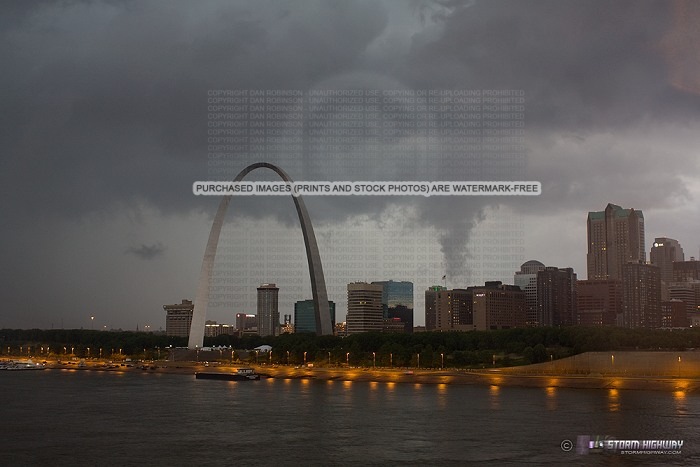
Examples of non-tornadic features
These pictures are examples of features that look like tornadoes or funnels, but were not in reality. These all failed to meet both of the two requirements listed above: no rotation or motion, and/or not in an updraft region.

And that, my friends, is why you only report what you KNOW you're seeing and not what you THINK you see. I wonder how many look-alikes have been reported as tornadoes. Probably a lot.
- Posted by Tim | | |
|