|
Home | Blog Index | Blog Archives | Christianity & Faith Essays | Storm Chasing Essays
Probable tornado in Vanceburg, Kentucky - October 7
VIDEO: Likely tornado near Vanceburg, KY on October 7, 2014
MAP: Google Maps location of intercept
Contrary to what most people might think, Kentucky is actually not that bad of a storm chasing state. The terrain is not impossible for storm chasing (albeit it is challenging, but not any more than eastern Oklahoma) and the region receives quite a few decent events each year. Despite that, a no-doubt-about-it, asterisk-free tornado intercept in the Bluegrass State has eluded me so far. I've busted on a few good Kentucky tornado days (notably March 2, 2012 and August 17, 2014). I have another "probably-a-tornado-but-not-certain" image from the Super Tuesday outbreak on February 5, 2008 near Crofton, Kentucky that I also don't "officially" count. Regardless, I LOVE chasing anywhere that most storm chasers don't even think of trying to. It makes any kind of intercept a satisfying and interesting one - to me anyway.
The Tuesday, October 7 event this week took place in the eastern part of the state - normally out of range had I been at home in St. Louis. However, this time, my medium-term business trip in Charleston, WV put me within range to jump on this setup. I left Charleston a little after 2PM to intercept storms crossing the somewhat diffuse warm frontal zone draped from near Cincinnati to the southeastern corner of Kentucky.
The initial activity consisted of a line of three distinct but loosely connected cores tracking between I-64 and the Ohio River. All had intermittent circulations on radar, some potent enough to be apparently tornadic. At least one fully-condensed tornado was documented by locals in Paris (north of Lexington) with the middle of the three cells. I could only choose one storm to intercept, due to the storm speeds and the curvy road network. I chose the northernmost of the three, as it appeared to be closer to the cool side of the frontal zone where winds were more backed. It was also slightly ahead of the other cells, with a better uncontaminated inflow trajectory.
I arrived in Vanceburg about 20 minutes ahead of the storm, and positioned on Route 8 to the north of town to intercept and chase the storm's area of interest. The meso was heavily rain wrapped, but the inflow notch cleared out enough to reveal a strong channel of inflow moving westward into the meso while the RFD surged east just to the south of it. The center of the circulation was mostly obscured by rain as it passed just to my north on Route 8, but a rather loud roar (waterfall) sound eminated from it. You can hear this on the video clip. The rain curtains were racing at tornadic speeds, and it looked (and sounded) very much like a non-condensed tornado was passing a few hundred yards to my northeast.
As I moved east to parallel the circulation, the RFD winds tore limbs and many leaves from trees along the road. At this point the tornado (or whatever this was) was moving farther away (the road was leading me south, the storm moving almost due east across the Ohio River north of Vanceburg). The video reveals what looks very much like a bowl or truncated cone funnel above where the loudest 'roar' noise was coming from:
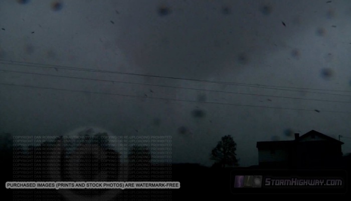
However, I could not conclusively tell if this feature was rotating or just a suspiciously-shaped wall cloud. The RFD wind was intense, and could have produced both the sound and the racing rain curtains. Upon returning to look for damage, I found a few 6 to 12 inch tree trunks snapped off midway along the path, but otherwise nothing really noteworthy (none of the houses and barns in the vicinity received any apparent damage). All things considered, though I am fairly certain a tornado was on the ground at this point (the video is pretty convincing to me), I'm not certain enough to officially count it as one. If someone else nearby had a better view and managed to catch an image of it, I might change my mind. It's definitely possible that it fully condensed either before or after the brief time I had a visual on it.
With another series of long work days ahead, I chose not to go farther west for the next round of after-dark supercells that tracked east of Lexington. Those looked even more intense on radar than the earlier storms, yet I haven't heard of any reports or imagery. Like many events in the Midwest, Kentucky is not covered well by storm chasers (often not at all), and therefore I suspect that many tornadoes go unreported/unrecorded. This is especially true if no structures are damaged.
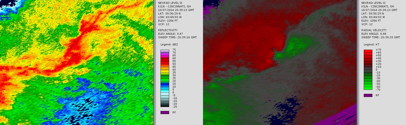
Here is a Level II radar image from the NWS KILN site (Wilmington, Ohio) showing the Vanceburg storm at the time of intercept. Due to the NCDC viewer currently exhibiting a positioning glitch (the viewer is displaying radar overlays about 50 miles north of where they should be), I removed the map layer from these images (click to enlarge):
|