|
Home | Blog Index | Blog Archives | Christianity & Faith Essays | Storm Chasing Essays
Eclipse update 3: Signs point to possible "Traffic Apocalypse" in St. Louis
We are four days out from the big event, and things are definitely getting interesting. The question on just how many people we can expect to be traveling to the path of totality has been answered in part by the fact that the hotels in the entire St. Louis metro area (not just the city) are 98% booked for Sunday-Tuesday as of the time of this post. No doubt, this will hit 100% very soon. That may be a first-ever in the city's history (I have not been able to find documentation of any other event that comes close).
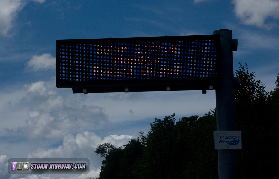
This is in addition to the multitudes more that will be driving in on Monday morning. Social media is abuzz with people excitedly sharing their plans for 13-hour drives and even flights from abroad. A special Amtrak eclipse train from Chicago sold out in 22 hours. MODOT has been sounding the alarm via social media and their network of electronic highway signs:

We've always known that the eclipse path would be seeing a major influx of people, but it's becoming apparent that we may be looking at a mind-boggling, historic all-time high. Simply put, the St. Louis metro area has likely NEVER seen this type of crowd in its history, and we don't have any precedent to draw on on what the impacts might be. Could it be similar to the December 16 ice invasion last year, or even worse?
I would be preparing for as much. Hotel reservations spike dramatically starting Sunday, which indicates that may mark the beginning of the traffic apocalypse. If I lived in or near the eclipse totality path - including the whole of the St. Louis metro and surrounding areas - I would be making preparations for the possibility that getting around between Sunday and Tuesday might not be a simple task. By that I mean, I would be stocking up on groceries and filling the gas tank by midday Saturday. It simply might not be feasible to do so from Sunday through Wednesday! For those that have to work Monday, expect major problems during your commutes, possibly rivaling the December 16, 2016 ice event.
As for getting to the eclipse path from outside: the earlier, the better. WAY earlier. I'm personally planning to be awake at 2AM to assess how bad the traffic is already, and leave soon thereafter if necessary. The 5-6AM departure times previously tossed around may not be early enough.
For those driving in from the north, as I detailed in a previous post, I would highly consider using the plentiful road network in Illinois to avoid the near-interstate and state highway corridors (and completely bypass St. Louis). The abundance of back roads on the Illinois side of the river will allow for people to spread out more, and offers the best chance of lower traffic numbers.
Cloud forecast update 3
Models are beginning to come into focus on the important Sunday-Monday timeframe. Unfortunately, they don't inspire much confidence. The models have trended much drier for this time period, but the indication of a thunderstorm complex on Sunday night-midday Monday as far south as central Missouri is definitaly making it a nail-biter. Things are not much better farther west, with even Nebraska threatened with overcast from a low pressure system and frontal boundary. All that being said, there are some breaks persistently showing up across the Plains and Midwest, any of which could save eclipse viewers at the last minute. So, I don't feel any different about my previous percentages: 60% chance of clouds across the Midwest.
The St. Louis National Weather Service Office has been issuing daily eclipse forecast updates for our area on their forecast discussions page. Bookmark that link and check it daily for a detailed synopsis from the professionals!
With the aforementioned traffic issues, I think it is increasingly unlikely that a last-minute reposition (as in, later than midnight Monday morning) is going to be possible. As always, keeping an eye out for realtime traffic (using Google Maps or similar) will be the thing to do.
| View 1,609 storm chases: |
| by year: |
|
| by type: |
|
|
|
GO: Home | Storm Chase Logs | Photography | Extreme Weather Library | Stock Footage | Blog
Featured Weather Library Article:
|