|
Home | Blog Index | Blog Archives | Christianity & Faith Essays | Storm Chasing Essays
Cloud forecasting overview for the 2017 total solar eclipse in the Midwest - Part 1
I've blogged about the potential traffic issues before, during and after the eclipse in the Midwest. This post will cover the other challenge for eclipse watchers: the risk for clouds to obscure the event from view.
Weather model forecasts are mostly useless more than 7 to 10 days out. Consistency and agreement across multiple models can extend that range a couple more days, only hinting at what type of large-scale pattern might occur. On the local scale, model forecasts aren't of any use until, at maximum, 5 days out. As of this post, we are 17 days from the eclipse, which is far beyond the range of any reasonable or useful forecast. So, in this first post, I will forego any forecast (one would be equivalent to a roll of the dice at this stage) and instead discuss the potential scenarios to watch for as we start getting glimpses of model forecasts for August 21.
There are five types of weather systems/patterns that pose the greatest threat of a complete shutout of the eclipse via a cloudy (overcast) or mostly cloudy sky. In no particular order, these are:
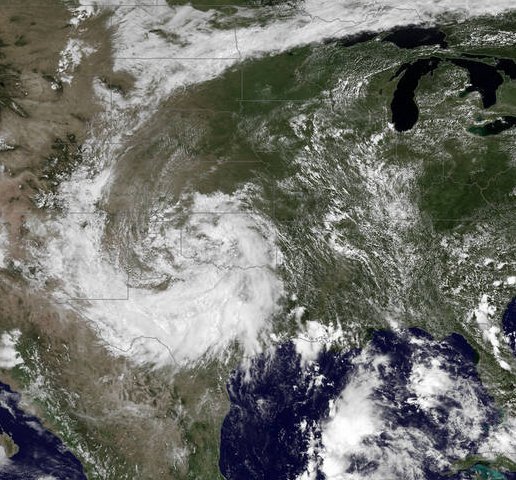
1. A long-lived thunderstorm complex (MCS):
A mesoscale convective system is a large complex of thunderstorms (usually a squall line) that, in the summer months, typically forms from late afternoon through the overnight hours. These complexes usually form on the northern periphery of a large surface high pressure system, in conjunction with a strong upper-level jet. In late summer, these MCSs commonly form in the eastern Great Plains or upper Midwest, and track east-southeastward during the overnight hours. While these complexes usually dissipate around daybreak, the leftover mass of clouds and light rain can persist for the rest of the day.
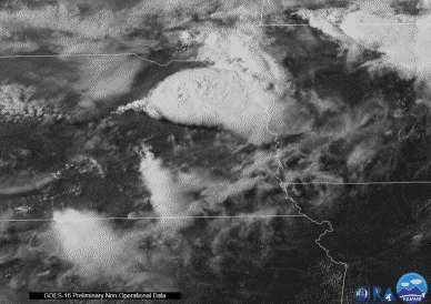
NOAA satellite image of a developing thunderstorm complex in Nebraska
An MCS would need to form at just the right time and place - probably eastern Nebraska or western Iowa (as in the example pictured above) - and track slowly southeast overnight in order to threaten the eclipse totality path in Missouri, Illinois, Kentucky and Tennessee with clouds. Predictors to watch in model forecasts for such an event would be a strong upper jet across the upper Midwest (anywhere from northern Missouri through Wisconsin) and a strong signal for precipitation anywhere from 2-3 days on either side of eclipse day. Another complication is "anvil blowoff" from the upper portions of a distant MCS. Upper-level winds can transport these high-level clouds very far from their origin. In such a case, the upper-level wind trajectories will be an important factor to watch if thunderstorms are forecast anywhere in the Great Plains or Midwest.
All this being said, an MCS track will be difficult to predict with much accuracy until 24-36 hours from the eclipse. This will make relocating along totality a difficult prospect, since one will have to make the trip at the last minute within the already congested traffic!
2.) A post-landfall tropical cyclone:
Possibly the worst-case scenario for eclipse watchers in the central US segment of totality would be a hurricane or tropical storm making landfall on the Gulf Coast on August 19-20, then drifting north across the Mississippi and Ohio valleys in the days following. Such a system could bring a massive overcast with rain, possibly clouding over the eclipse path from Nebraska to South Carolina!
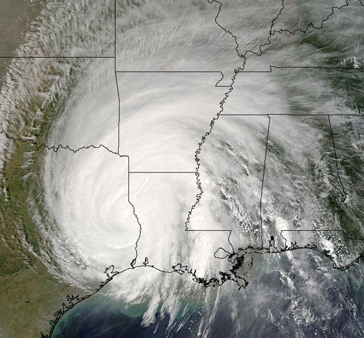
NOAA satellite image of post-landfall Hurricane Rita in 2005
Thankfully, this type of event should be easy to forecast in advance. A tropical system should show up prominently in model forecasts within 10 days, with the general track becoming apparent within 5 days. Such a scenario would likely involve a very long trip to relocate to a clear eclipse viewing site - possibly as far as central or western Nebraska! Of course, this will multiply the traffic levels by several degrees. In the event of this scenario, I would be leaving for Nebraska at least 2 days in advance!
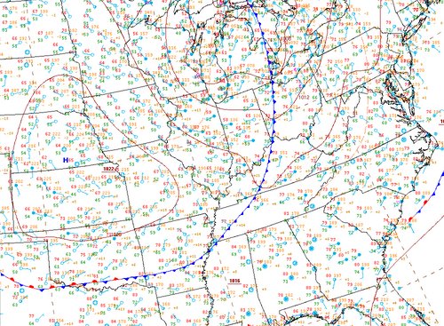
3. A stationary frontal boundary:
Cold fronts sinking southward from the Upper Midwest are common in late summer, and often are the triggers for the MCSs discussed in item #1. Clouds and new storms often develop along such boundaries, and wherever the front inevitably stalls, there could be a persistent cloud threat for days.
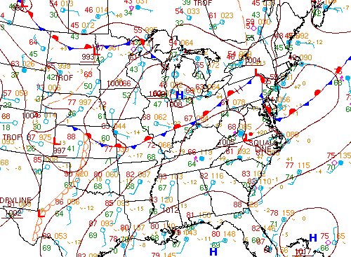
Surface chart showing Midwest stationary front
Most stalled fronts in the Midwest are oriented east-west. Thankfully, such features are large-scale (synoptic) in size, and typically well-resolved in models. The exact placement of such a front is usually hard to pin down, but the presence of one in the general area of the eclipse path in model forecasts will be of concern.
4. A dense field of cumulus clouds:
The most likely scenario for eclipse day will be fair-weather cumulus clouds, which form as the sun heats a moist air mass at the surface. These are a near-daily occurrence pretty much anywhere in the eclipse path during the summer months. What could be problematic, however, is if these cumulus clouds begin developing very early in the day, before 11AM, and grow into "cumulus congestus" or incipient thunderstorms by eclipse time.
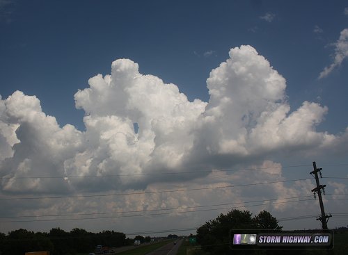
Dense cumulus congestus clouds
The good news is, most cumulus fields are not dense during the early afternoon. And, barring such a densely-packed cloud field, it will take a highly coincident cumulus cloud passing in front of the sun at just the exact time to block an chaser's view. The other factor working in our favor is that most cumulus fields are in their infant stages around noon, and will likely be in a very early (small) stage of development during totality between 1 and 2 PM.
5. A cutoff (closed) low:
A cutoff or closed low is a closed circulation in the upper-level jet stream. They are called "cut offs" because they are separated from the main west-to-east progression of the mean upper level winds across the country. What this means is that once they form, cutoff lows move very slowly - and sometimes not at all - for days at a time.
NOAA satellite image of a cutoff low in the Southern Great Plains
Like a remnant tropical cyclone, a cutoff low would be close to a worst-case scenario, threatening clouds and rain for a large portion of the eclipse totality path. Such a pattern should also be very evident in model forecasts many days in advance, at the very least allowing for sufficient time to relocate to another eclipse viewing site (albeit with the amplified traffic issues).
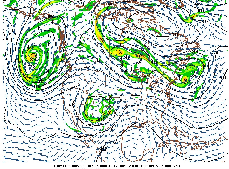
Upper level model chart of a cutoff low over New Mexico and west Texas
Other sources for overcast exist, but are rare in late August in this part of the country at the time of day totality will occur:
- 6. Thunderstorms: Cumulus clouds (discussed above in item #4) are the precursors to thunderstorms. Thankfully, the vast majority of thunderstorms do not develop until mid to late afternoon (3 to 6 PM). So, absent a stationary frontal boundary (discussed above), thunderstorms should be a non-factor for a 1 to 2 PM totality time.
- 7. Fog: Fog is rare in late August in the Midwest, and even if it does occur, it almost always dissipates completely before mid-morning.
- 8. Stratus: the most likely source of a stratus deck in late August will be a remnant MCS discussed in item #1 above. Apart from remnant thunderstorms, most large stratus decks are associated behind strong cold fronts or in the vicinity of low pressure systems in the fall, though a tropical cyclone or cutoff low will also threaten this type of cloudiness.
Unfortunately, at least one of the weather systems mentioned in items 1-5 is likely to be present somewhere east of the Rockies. This means it is almost certain that some parts of the eclipse path will be afflicted with clouds. Fortunately, the worst-case scenarios will be the easiest to see coming many days in advance, allowing for some possibility of relocating for clearer skies - again, at the expense of even more traffic congestion.
So, what are the best-case weather patterns for the Midwest during the eclipse? Here is what I am hoping for:
- a). The day after a strong evening cold frontal passage. A cold front sweeping through late on the 20th and pushing well to the south or east of the area would be the absolute best-case scenario for eclipse viewing in the Midwest. Cooler, drier air behind a fresh cold frontal passage would usually mean clear skies for much of the following day, with little to no cumulus development.
Surface chart of a clear day behind a cold front
- b). A large, persistent high pressure 'ridge' centered directly over St. Louis. This setup would likely keep the MCS tracks and anvil cloud blowoff far to the north over Minnesota/Wisconsin. Afternoon pop-up thunderstorms are a threat in this type of pattern, but most will not get going until mid/late afternoon, well after totality. A cumulus field would be a concern, however.
Where to view model data
The College of Dupage model site is one of the better places to view data from many various models as we approach the eclipse. The GFS and ECMWF models give a picture from 7 to 10 days, the NAM within 4 days and the HRRR and NAM NEST the best models for short-term (24-48 hours) forecasts.
NCEP spaghetti plots offer some additional long-range guidance on the overall jet stream pattern.
Also, here are Smoke forecasts for the western parts of the eclipse path.
I will be making updates to the cloud forecast once we are within a reasonable window to do so (within 10-12 days), so stay tuned!
GO: Home | Storm Chase Logs | Photography | Extreme Weather Library | Stock Footage | Blog
Featured Weather Library Article:
|


