|
Home | Blog Index | Blog Archives | Christianity & Faith Essays | Storm Chasing Essays
Plains trip #2: Expedition logs for May 6-8
Plains storm chase expedition #2 for 2019 is on the books. This trip was not a successful one tornado-wise, and was characterized by multiple equipment failures. The lightning was also not as cooperative as I had hoped, but I didn't come away completely empty-handed on high speed captures.
The following are the logs of the three days of this trip (2019 Plains trips 4, 5 and 6):
Day 4: Central Kansas supercells and lightning
VIDEO: Kansas lightning
GPS LOG: 5/6 trip path
I left St. Louis at 8AM to begin the trip west. When I started firing up my laptop chasing applications, I discovered my GPSGate software had stopped working since I had reconfigured the cabling in my vehicle. After some roadside troubleshooting, I discovered the issue was a software licensing problem triggered by switching the USB port of the GPS antenna puck. After that was fixed, I resumed the trek west.
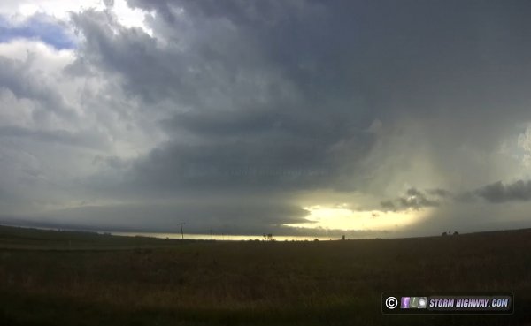
I started the chase from Abilene, Kansas right on the stationary boundary. It was more like a weak cold front sagging south. This movement increased as two storms developed to its north, and the boundary raced south across I-70 through Abilene with the push of outflow. I didn't expect the storms to catch up to the boundary, deciding to start heading west to where the front would be more stable. At that point, the lead storm did catch up to the front near Junction City, but I was too far west and out of position.
I dropped southwest to new storms south of the boundary, one of which had some nice structure near Assaria.
As I made this move, my main power circuit dropped out completely. I lost all dashcams, chargers and laptop power. During the stop to troubleshoot, I received a call from a storm chaser friend, and in the chaos of attending to both the conversation and the repairs, set my phone down on the trunk of the car. I finally determined the cause of the failure, it was my Startguard UPS unit that protects the circuit from voltage drops during cranking the engine. The fuse was OK, so the unit must have failed. I bypassed the Startguard and was up and running. About 20 minutes later, the power flickered and dropped again! This time, it was my main on/off dashboard switch for the power circuit, the contacts had physically failed. This might have been going on for some time, which could have been what fried the Startguard. I removed the switch, connected the two leads with a wire nut and was back on the road.
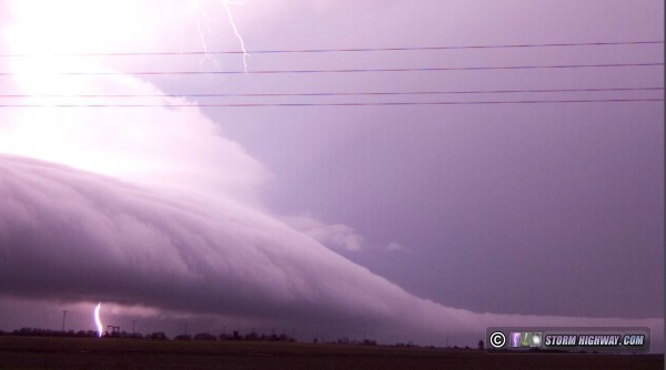
The storm at New Gottland intensified rapidly, and I positioned in the notch of the storm. I chased strong RFD (descending motion) but no countering surface inflow. My car took a pounding from tennis ball sized hail here, but all windows survived thanks to the hail guards. I moved ahead of this storm to try and capture some of the lightning in the vault region, grabbing a couple of bolts in high speed (video is at the beginning of this post).
I moved south to intercept additional storms, but none were able to become as organized. After some more failed lightning attempts, I got a hotel in Wichita and arrived at 11:00pm. As I got all of my gear together to take inside, discovered my phone still sitting on the trunk hail guard. It had miraculously not blown off, but was soaking wet from several downpours and probably several major hail impacts. I removed the battery, took it inside and set it in front of a fan overnight. In the morning, I powered it up, and it works. The screen is splotched but still operational.
Even with all of the equipment failures, I'm thankful it was not worse. Everything was repairable, and for the most part, did not impact the chase. Day 5: Texas Panhandle supercells
GPS LOG: 5/7 trip path
The second day of this less than stellar storm chase expedition started in Wichita at 8AM. I thought I left in plenty of time to get to Amarillo and refine the target for the day. After nearly constant road construction speed restrictions on Highway 60, I arrived just after 2PM. But there was no time to refine the target, storms had already fired. The one item I had identified from radar loops was an outflow boundary left from overnight storms. I figured this would be north of I-40 by storm time.
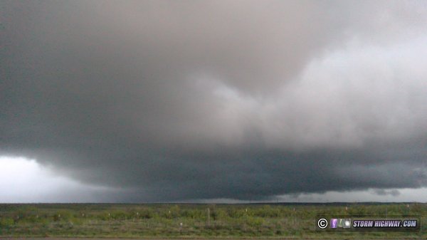
I drove up to the storm near Ady, finding it cold with no surface inflow. I dropped south to Bushland and awaited the next cell to approach. It ramped up in intensity right overhead, and I stairstepped northeast to stay with it all the way to Highway 87 north of Amarillo. Surface inflow was present with this storm, but it was getting destroyed by the RFD. The closest this storm came to producing a tornado was this 30-second circulation that tightened up just north of Givens Avenue west of Highway 87, but it was quickly blown apart by the RFD:
Due to the constant driving to keep up, I didn't shoot any stills of the storm. I figured I could pull from the dashcams later. Seeing no further potential with this storm, I finally bailed and headed for the storm far to the south near Tulia. I was still 25 miles away on I-27 when the tornadoes with it were reported.
Seeing an intercept path ahead that would take me into the Palo Duro Canyon with no services, I needed to stop and get gas again prior to that move. By the time I realized this, I was south of Canyon on I-27. I thought I'd get gas in Happy. But, I discovered upon arrival that there were no gas stations in the town. I would have to go to Tulia to fuel up, completely losing the storm. In Tulia, my credit card would not work at the pump, so I had to go inside to the cashier. When I finally got back on the road, I was way out of position. I managed to catch up to the RFD of the strong circulation near Vigo Park, but with the blinding rain, I couldn't see a thing.
I continued on north to I-40 in a last attempt to get back ahead. I was successful, beating the circulation to Alanreed/McLean. It was completely rain-wrapped and invisible, even from within the notch of the storm. With darkness setting in, I decided to call the tornado chase and head into Oklahoma City for upward lightning as the MCS moved through. I arrived far enough ahead that I was able to get a few hours' sleep before the storms' arrival. Day 6: Oklahoma City upward lightning
VIDEO: Upward lightning in OKC
GPS LOG: 5/8 trip path
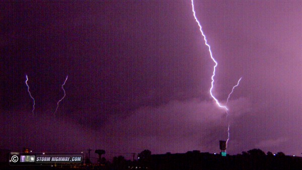
At 5AM, the previous day's storms to the west had congealed into a line and were moving through the OKC metro. I went out as the trailing stratiform of the storms arrived to capture lightning to the tower farm on the north side of the city, but the wind continually shifted and blew rain onto the lens, requiring several frustrating repositions. A little-known fact about OKC is that despite being in the Great Plains, it is actually one of the worst places to chase. Most of the city is heavily forested, and finding roadside pull-offs with open views is very difficult. Add to this that low clouds and fog were rolling in. It didn't matter anyway: the electrified stratiform shield was exiting the city early, taking with it the lightning activity. The only capture I managed was one upward flash to four towers from my hotel parking lot:
The high-speed video from this is included at the beginning of the video linked at the top of this page.
This day (Wednesday the 8th) had originally been shown by models to be a major storm chase day in Oklahoma as the upper trough ejected eastward. But, thanks to the extensive overnight thunderstorm complex, deep moisture was being scoured out from the region and pushed south to I-20 in north Texas. This was too far away from the best upper level wind support, and too far for me to consider driving for such a low-end setup. Models showed a potential supercell developing in southwest Oklahoma later that evening, but with dewpoints in the high 50s, it would be unlikely to have much of a tornado threat. I decided to instead use the day to get back home, making it back around 8PM that evening.
GO: Home | Storm Chase Logs | Photography | Extreme Weather Library | Stock Footage | Blog
Featured Weather Library Article:
|


