|
Home | Blog Index | Blog Archives | Christianity & Faith Essays | Storm Chasing Essays
Great Plains 2019 Storm Chasing Expedition Logs
The 2019 spring tornado season in the Great Plains was a very active one, but also very challenging and frustrating for storm chasers. Many days with tornado-favorable parameters failed to produce. Other days with multiple targets saw tornadoes happen in only one or two of them, leaving storm chasers in the other targets empty-handed. Significant flooding and storms traversing limited road networks caused navigation and traffic problems. The extended nature of the active pattern required higher travel costs for a storm chaser to cover everything, often with little to show for the extra expense.
Still, as with any season, one must focus on what there was to be thankful for, and I had plenty of such blessings. I chose to leave a day earlier than planned for trip #3, a decision which resulted in capturing one of the best tornado days of the sequence. I got stuck on a dry dirt road in Texas, but was rescued rather quickly by a local resident prior to the arrival of heavy rain - avoiding a potentially long and costly ordeal. The car has performed without major issues for the over 15,000 miles. Above all, I am always grateful for safety and relative lack of crises during those long miles, as there are many perils that can afflict a storm chaser on such a long journey.
I logged 18 Great Plains weather storm chase days for the season during three separate trips. That is second only to my all-time record of 22 days set in 2005!
 Day 1: St. Louis to Shamrock, Texas (Trip #1 start) Day 1: St. Louis to Shamrock, Texas (Trip #1 start)
The first day of 2019 Great Plains storm chase expedition travel was on Thursday, March 21. I left St. Louis before noon, heading down I-44 to Oklahoma City, then west on I-40 to the storm chaser-familiar town of Shamrock for the night.
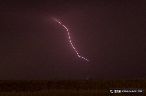
The first tornado of the year and a great upward lightning show in Amarillo. This chase has its own log page here.
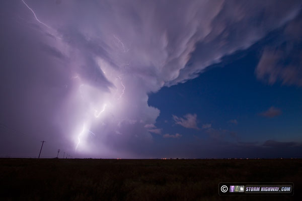
A supercell develops along the cold front in the heart of Oklahoma City. This chase has its own log page here.
 Day 4: May 6: Central Kansas supercells and lightning (Trip #2 start) Day 4: May 6: Central Kansas supercells and lightning (Trip #2 start)
VIDEO: Kansas lightning
GPS LOG: 5/6 trip path
I left St. Louis at 8AM to begin the trip west. When I started firing up my laptop chasing applications, I discovered my GPSGate software had stopped working since I had reconfigured the cabling in my vehicle. After some roadside troubleshooting, I discovered the issue was a software licensing problem triggered by switching the USB port of the GPS antenna puck. After that was fixed, I resumed the trek west.
I started the chase from Abilene, Kansas right on the stationary boundary. It was more like a weak cold front sagging south. This movement increased as two storms developed to its north, and the boundary raced south across I-70 through Abilene with the push of outflow. I didn't expect the storms to catch up to the boundary, deciding to start heading west to where the front would be more stable. At that point, the lead storm did catch up to the front near Junction City, but I was too far west and out of position.
I dropped southwest to new storms south of the boundary, one of which had some nice structure near Assaria.
As I made this move, my main power circuit dropped out completely. I lost all dashcams, chargers and laptop power. During the stop to troubleshoot, I received a call from a storm chaser friend, and in the chaos of attending to both the conversation and the repairs, set my phone down on the trunk of the car. I finally determined the cause of the failure, it was my Startguard UPS unit that protects the circuit from voltage drops during cranking the engine. The fuse was OK, so the unit must have failed. I bypassed the Startguard and was up and running. About 20 minutes later, the power flickered and dropped again! This time, it was my main on/off dashboard switch for the power circuit, the contacts had physically failed. This might have been going on for some time, which could have been what fried the Startguard. I removed the switch, connected the two leads with a wire nut and was back on the road.
The storm at New Gottland intensified rapidly, and I positioned in the notch of the storm. I chased strong RFD (descending motion) but no countering surface inflow. My car took a pounding from tennis ball sized hail here, but all windows survived thanks to the hail guards. I moved ahead of this storm to try and capture some of the lightning in the vault region, grabbing a couple of bolts in high speed (video is at the beginning of this post).
I moved south to intercept additional storms, but none were able to become as organized. After some more failed lightning attempts, I got a hotel in Wichita and arrived at 11:00pm. As I got all of my gear together to take inside, discovered my phone still sitting on the trunk hail guard. It had miraculously not blown off, but was soaking wet from several downpours and probably several major hail impacts. I removed the battery, took it inside and set it in front of a fan overnight. In the morning, I powered it up, and it works. The screen is splotched but still operational.
Even with all of the equipment failures, I'm thankful it was not worse. Everything was repairable, and for the most part, did not impact the chase. Day 5: May 7: Texas Panhandle supercells
GPS LOG: 5/7 trip path
The second day of this less than stellar storm chase expedition started in Wichita at 8AM. I thought I left in plenty of time to get to Amarillo and refine the target for the day. After nearly constant road construction speed restrictions on Highway 60, I arrived just after 2PM. But there was no time to refine the target, storms had already fired. The one item I had identified from radar loops was an outflow boundary left from overnight storms. I figured this would be north of I-40 by storm time.
I drove up to the storm near Ady, finding it cold with no surface inflow. I dropped south to Bushland and awaited the next cell to approach. It ramped up in intensity right overhead, and I stairstepped northeast to stay with it all the way to Highway 87 north of Amarillo. Surface inflow was present with this storm, but it was getting destroyed by the RFD. The closest this storm came to producing a tornado was this 30-second circulation that tightened up just north of Givens Avenue west of Highway 87, but it was quickly blown apart by the RFD:
Due to the constant driving to keep up, I didn't shoot any stills of the storm. I figured I could pull from the dashcams later. Seeing no further potential with this storm, I finally bailed and headed for the storm far to the south near Tulia. I was still 25 miles away on I-27 when the tornadoes with it were reported.
Seeing an intercept path ahead that would take me into the Palo Duro Canyon with no services, I needed to stop and get gas again prior to that move. By the time I realized this, I was south of Canyon on I-27. I thought I'd get gas in Happy. But, I discovered upon arrival that there were no gas stations in the town. I would have to go to Tulia to fuel up, completely losing the storm. In Tulia, my credit card would not work at the pump, so I had to go inside to the cashier. When I finally got back on the road, I was way out of position. I managed to catch up to the RFD of the strong circulation near Vigo Park, but with the blinding rain, I couldn't see a thing.
I continued on north to I-40 in a last attempt to get back ahead. I was successful, beating the circulation to Alanreed/McLean. It was completely rain-wrapped and invisible, even from within the notch of the storm. With darkness setting in, I decided to call the tornado chase and head into Oklahoma City for upward lightning as the MCS moved through. I arrived far enough ahead that I was able to get a few hours' sleep before the storms' arrival.  Day 6: May 8: Oklahoma City upward lightning (Trip #2 end) Day 6: May 8: Oklahoma City upward lightning (Trip #2 end)
VIDEO: Upward lightning in OKC
GPS LOG: 5/8 trip path
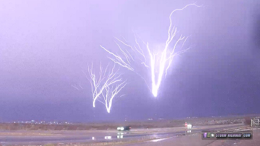
At 5AM, the previous day's storms to the west had congealed into a line and were moving through the OKC metro. I went out as the trailing stratiform of the storms arrived to capture lightning to the tower farm on the north side of the city, but the wind continually shifted and blew rain onto the lens, requiring several frustrating repositions. A little-known fact about OKC is that despite being in the Great Plains, it is actually one of the worst places to chase. Most of the city is heavily forested, and finding roadside pull-offs with open views is very difficult. Add to this that low clouds and fog were rolling in. It didn't matter anyway: the electrified stratiform shield was exiting the city early, taking with it the lightning activity. The only capture I managed was one upward flash to four towers from my hotel parking lot:
The high-speed video from this is included at the beginning of the video linked at the top of this page.
This day (Wednesday the 8th) had originally been shown by models to be a major storm chase day in Oklahoma as the upper trough ejected eastward. But, thanks to the extensive overnight thunderstorm complex, deep moisture was being scoured out from the region and pushed south to I-20 in north Texas. This was too far away from the best upper level wind support, and too far for me to consider driving for such a low-end setup. Models showed a potential supercell developing in southwest Oklahoma later that evening, but with dewpoints in the high 50s, it would be unlikely to have much of a tornado threat. I decided to instead use the day to get back home, making it back around 8PM that evening. Day 7, May 16: St. Louis to Wilson, Kansas (Trip #3 start)
GPS LOG: 5/16 trip path
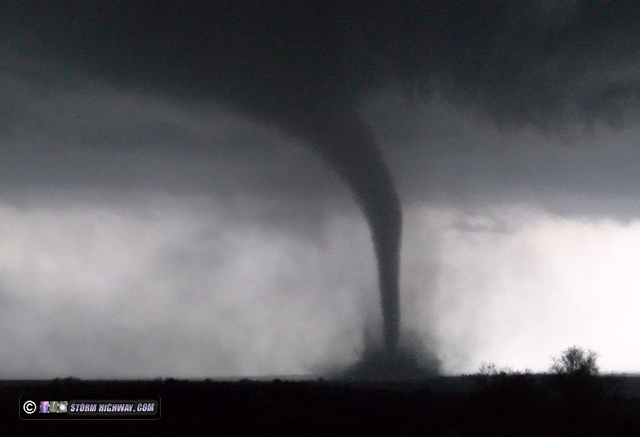
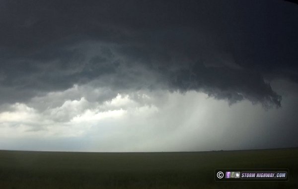
Day 7 was a travel day to start Great Plains trip #3 for the season. Hotels were completely booked in Hays/Russell, my originally-planned stop, thanks to college graduation events. I found a nice historic hotel in Wilson where I ended the day. An excellent storm chase day in Nebraska yields two close intercepts of developing tornadoes and a nice long-lived photogenic tornado. This chase has its own page here.
 Day 9, May 18: Northern Oklahoma severe storms Day 9, May 18: Northern Oklahoma severe storms
VIDEO: 4-way dashcam timelapse of entire day
GPS LOG: 5/18 trip path
A low-key day for supercells thanks to an expansive early morning thunderstorm complex that scoured out available moisture. After starting out with an oil change in Dodge City, I ended up on several marginal supercells in Oklahoma from Alva to near Blackwell that quicly became outflow dominant. I ended the day in Perry.
Catch of the day was this high speed lightning capture near Billings:
Day 10, May 19: Down day in Oklahoma City
GPS LOG: 5/19 trip path
A rare "down day" for me in the Plains as the atmosphere recharged between systems. I had time to put together a Youtube edit of the Nebraska tornado event on Day 8. My Verizon Jetpack stopped working in the morning, requiring a drive around the western OKC metro to find a replacement. Also bought 2 new tires for the car and had them mounted and balanced. Ended the day in Sayre.  Day 11, May 20: North Texas tornadoes and lightning Day 11, May 20: North Texas tornadoes and lightning
VIDEO: Paducah, TX tornadoes
VIDEO: 4-way dashcam timelapse of entire day
GPS LOG: 5/20 trip path
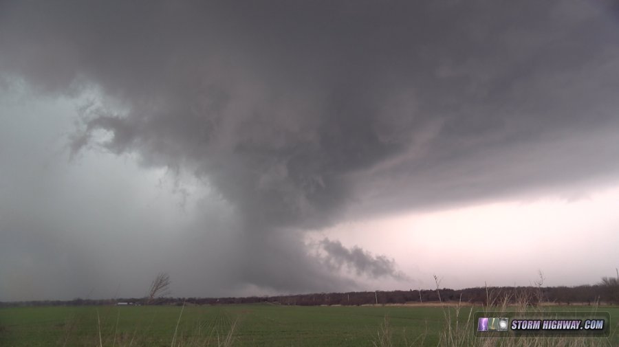
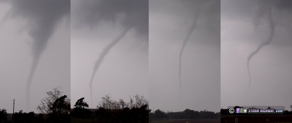
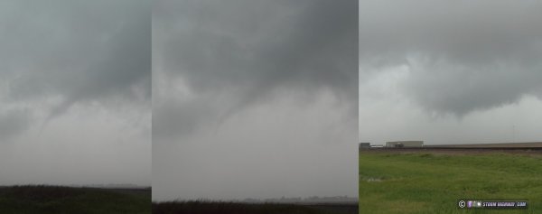
The parameters for this day pointed to a historic tornado outbreak, but the conditions failed to materialize. I started in Hollis, then drove south to a supercell in Texas just in time to see two tornadoes near Paducah. I then got stuck on a dry but soft sand road near the Red River for an hour, losing the storm. Thankfully I was pulled out by a local resident before rain arrived. The big outbreak was not to be, so there were no other viable target storms. I ended the day in Lawton, Oklahoma.
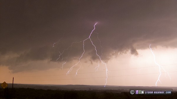
This first montage shows the stages of the first Paducah tornado, the second image is a frame from high-speed video of cloud-to-ground lightning stepped leader in front of a supercell wall cloud:
Day 12, May 21: Central Kansas marginally severe storms
GPS LOG: 5/21 trip path
I headed north this day for a cold-core tornado setup in central Kansas, electing to not go home for the tornado risk in St. Louis due to probable rain-wrapping issues with any storms there. My surface observations data feed stopped updating early in the afternoon, so I ended up out of position for the tornado event north of I-70 in northeastern Kansas. Saw some briefly severe storms near Lyons and Salina. Ended the day in Wichita.
Storm near Lyons, Kansas
 Day 13, May 22: Central Oklahoma bust Day 13, May 22: Central Oklahoma bust
GPS LOG: 5/22 trip path
This was my second bust day in a row thanks to bad chase decision making and/or execution. Starting from Wichita in the morning, I originally targeted Baxter Springs and began heading in that direction. I had my reservations about this area due to boundary-parallel flow and flooding, but felt it had the best potential for sustained convection over that in Oklahoma.
I normally make data check stops every 30 minutes or so during storm chase days, and after about an hour, started seeing the potential for solid convective initiation and sustainment in Oklahoma. This was enough for me to switch my target mid-chase to Oklahoma about 20 minutes before the PDS watch issuance. But upon making this choice, I could not verify that the route due south through Oklahoma was NOT flooded. Oklahoma's DOT map web site was down. Furthermore, several of the routes showed no live traffic data, which cast doubt on their viability. Worried that I'd encounter a closed flooded road in Oklahoma with a 50-mile backtrack, I elected to play it safe and go back west to I-35, then south. This put the lead storms in the Shawnee area out of play for me.
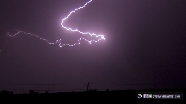
I headed for the storm at Perry, which was encountering the frontal boundary (which by now should have been lifting north). But Stillwater's ASOS still showed northwest winds, and all of the wind turbines as I neared the area were pointing in that direction also. When I arrived on the storm south of Perry, it was already north of the boundary. A nice lightning barrage gave me only one more after I put the camera on it:
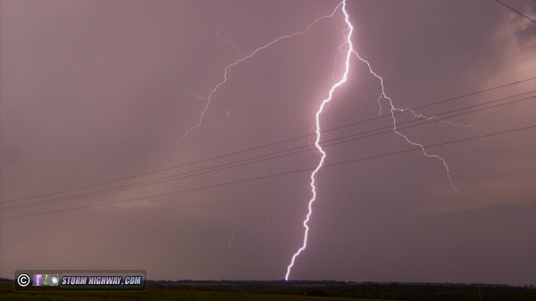
CG lightning at Perry, OK
Driving south of the storm, I finally encountered calm winds south of the front, but they soon shifted to the north - confirming the boundary was still pushing south as a cold front. This essentially killed my chase. There were new storms on this boundary to my west, but were a lost cause since they were already getting undercut by the front.
The only other storms far enough south to not be in danger of the front undercutting were down south of I-40, but they slowly weakened as I approached, struggling with the cap. Finally, storms along I-44 began to sustain, but all but the one down at Wichita Falls were dominant left movers with no hope of rooting at the surface. I went over to one of them anyway at El Reno for lightning shots, but they weren't even producing that. My chase was over before sunset, and I headed to my hotel in Edmond. Day 14, May 23: Texas Panhandle bust 1
GPS LOG: 5/23 trip path
I left Oklahoma City by midday and headed to Amarillo, where I found the stationary frontal boundary slowly sagging southward through the city. Not good for an storm chase day in the Panhandle! Feeling that this would ruin the chances for tornadoes from Amarillo northward, I headed south on I-27 to isolated storms southwest of Lubbock. Storms developed just behind me as I drove south, but they were all behind the cold front. This had the effect of accelerating the cold front's southward push even more. The environment in the Lubbock region had problems as well, mainly lesser low-level shear and a stout cap with mesoanalysis indicating 700mb temps of 12-14C. Storms would struggle in every way, but I didn't see a better option. The storms near Lubbock were the only ones that had a shot to organize before the cold front arrived and killed their low levels.
As I feared, the cap started supressing the storms as I arrived on them at Ropesville. The other problem I was having was visibility. Smoke from Mexican wildfires had created a severe haze, making storm visibility difficult even two or three miles away. It was all for naught: the cap kept the Lubbock area storms from organizing until the cold front finally reached the metro area. The storms flared for some time thereafter, producing little more than heavy rain and (mostly non-photogenic) lightning.
Downward positive CG lightning initiates upward leader near Ropesville, TX
I called the chase after sunset and headed to my hotel in Plainview, where I read about the northern storms managing to fight back the cold front and produce a few large tornadoes. Day 15, May 24: Texas Panhandle bust 2
GPS LOG: 5/24 trip path
Started in Plainview, Texas. Made it to Lubbock and was on the storm just after noon that had a nice wall cloud with strongly-rising scud tags near the ground. That was the best thing I saw all day. I dropped south to the next cell, which became the dominant one as it moved over the city. However, it and the previous storm had already sent outflow far ahead of the updrafts, so tornado potential was near zero until something could get ahead of that.
Finally a storm fired down near Post that had a shot before moving across the boundary, but it could not root. I tried getting back ahead of the mess again, but encountered field-to-field flooded roads south of Crosbyton with dry spots on the road closing up fast. I wanted none of that, and turned around, which was essentially a decision to abandon that cluster of storms. I'd have a 2-hour drive to get back ahead to Paducah to the only storm that seemed to not be hopelessly undercut, and it didn't seem worth it.
I went back to the dryline/outflow boundary intersection at Brownfield hoping for a strong updraft to go up on it and at least spin up a landspout before crossing. This almost happened, as a storm went up right at the intersection near Levelland but quickly sent outflow racing south and west, killing any hope of that.
I waited for the storm to cross, then headed north to flank the storm to the west to avoid flooding in Lubbock and New Deal. During this time, there was some nice lightning and sunset colors, which provided some scenes worth stopping to shoot.
Supercell lightning at Littlefield, TX
Ended the day at my hotel in Plainview for the 2nd night in a row. Day 16, May 25: Southwest Kansas supercell
GPS LOG: 5/25 trip path
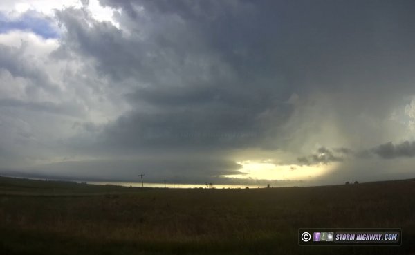
I started my day in Plainview and headed north. This was another event with early promise dashed by storms firing in the target by midday. The only viable area that remained without early-day convection was east of the dryline in southeastern Colorado, and a nice storm initially fired there by midafternoon. After encountering a road snafu where the highway dead-ended into mud at the Colorado state line north of Elkhart, Kansas, I finally arrived on the storm south of Manter, KS. I found it rather high-based and anemic, with strong outflow and RFD working in concert to kill surface inflow. I followed the storm to Johnson City, missing a reported landspout from the storm.
Supercell at Manter, KS
I decided to head east to try and catch up to a more robust complex of cells moving northeast toward Dodge City to at least get some lightning video. As I did this, a new storm fired just ahead of me over Ulysses, Kansas, sitting over the town for more than 30 minutes ahead of me. When I reached the town, deep flooding had already rendered the roads and streets impassable. With no route east, I was forced to turn south, losing my ground on the Dodge City storms and ending up out of position for catching up. Despite it being only late afternoon, I was out of target options. I booked my room in Dodge City and arrived there before sunset. Day 17, May 26: Dodge City, Kansas area spinups
GPS LOG: 5/26 trip path
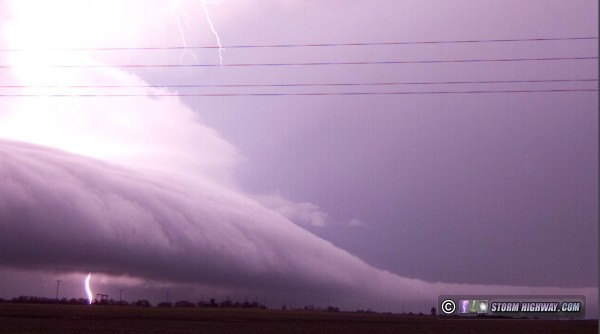
Awoke in Dodge City and targeted Lamar, Colorado. I made it to Syracuse, KS as the first storms of the day started going - one near Springfield, CO and another farther north. I waited to see how these would evolve before choosing. Skies over Syracuse were overcast and the southeasterly winds were cold. This was the upstream air that any CO storms would be ingesting, so I felt the day was done. As the Springfield storm faded to nothing, I felt my concerns were correct - so I decided to ditch the main target and head east for the more solid convection in the Liberal area that should be encountering the frontal boundary near Dodge City. I arrived on these at Ensign. The radar was a mess, but I was surprised to see very fast inflow with RFD surges evident. This managed to wrap up several times in rapid circulations with funnels that either were very close to producing, or did actually produce. None lasted more then a couple of minutes. Lightning was intense during this, with many bolts hitting the wind turbines.
Spinups at Ensign, KS
After this storm encountered the stable air east of the boundary, I contemplated heading back west to the zone of clearing that managed to take place ahead of the dryine. But that 2-hour drive back where I just came from for a short window of daylight storms was daunting. The next two days would be the final ones of the active Plains pattern, and I was frustrated and ready to just give up and go home. I then saw that the 18z runs of the models were developing a potent supercell/tornado environment in Illinois back home the next day. That was all I needed to see to begin the trek back east, once again ending a Plains trip before sunset. I made it to my hotel in Cameron, Missouri at 1AM. Day 18, May 27: Illinois supercell (Trip #3 end)
GPS LOG: 5/27 trip path
A tornado setup in Illinois this day prompted me to end my Plains trip 2 days early. Since my target was on the warm front between Davenport, Iowa and Peru, Illinois, US 36 across northern Missouri was the travel route instead of going back home via I-70 through St. Louis. That is, I didn't go home before this chase, so it "counts" as part of the main expedition. I left Cameron, MO about an hour late due to a miscalculation about the transit time, which put me behind the initial storms on the Iowa/Illinois border. I finally reached the target storm northeast of Mendota, but once again found the storm outflow dominant with no visible surface inflow making it over the huge shelf cloud continous from the RFD gust front to the forward flank. Despite this, the storm managed to produce a small tornado at Paw Paw immediately after I left it. Storms were moving fast this day also, meaning when the Indiana border-area storms got going, I was too far west to be in position to reach them.
I didn't take any photos or videos this day. My chase was essentially over at 7PM. I called it and started the drive south to home, finally arriving at 8:30PM to bring Plains trip #3 for the year to a close.
GO: Home | Storm Chase Logs | Photography | Extreme Weather Library | Stock Footage | Blog
Featured Weather Library Article:
|


