|
Home | Blog Index | Blog Archives | Christianity & Faith Essays | Storm Chasing Essays
2023 Great Plains Storm Chasing Expeditions
After it appeared that the Great Plains would not offer any spring setups worth traveling for, a respectable multi-day tornado risk quickly materialized in mid-June, well after my usual end-of-season time. This resulted in a four-day Plains trip from June 15 to June 18.
2023 Great Plains Season Totals:
- Plains tornadoes: 1
- Plains chase days: 4
- Plains chase mileage: 2,640
Great Plains Expedition Days
 Day 1, June 15: Southern Oklahoma supercells (Trip #1 Start) Day 1, June 15: Southern Oklahoma supercells (Trip #1 Start)
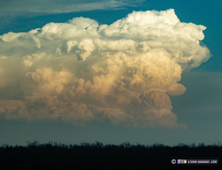
I left St. Louis just after midnight and drove to El Reno to stage for Thursday's setup, meeting up with Greg McLaughlin and crew from Tulsa. Models indicated two areas of potential that I was interested in: an arc of supercells from southwestern Kansas to Interstate 40 near Shamrock, and a lead supercell shown initiating ahead of that activity in southwest Oklahoma. As with most setups in the Plains, shear was better in the northern target, but instability was greater in the southern one. The issue for both targets was large temperature/dewpoint spreads and high storm bases. Moisture in the northern area was shown mixing out significantly during the afternoon, while the southern target had temperatures approaching 100°F - neither a good sign for tornado potential.
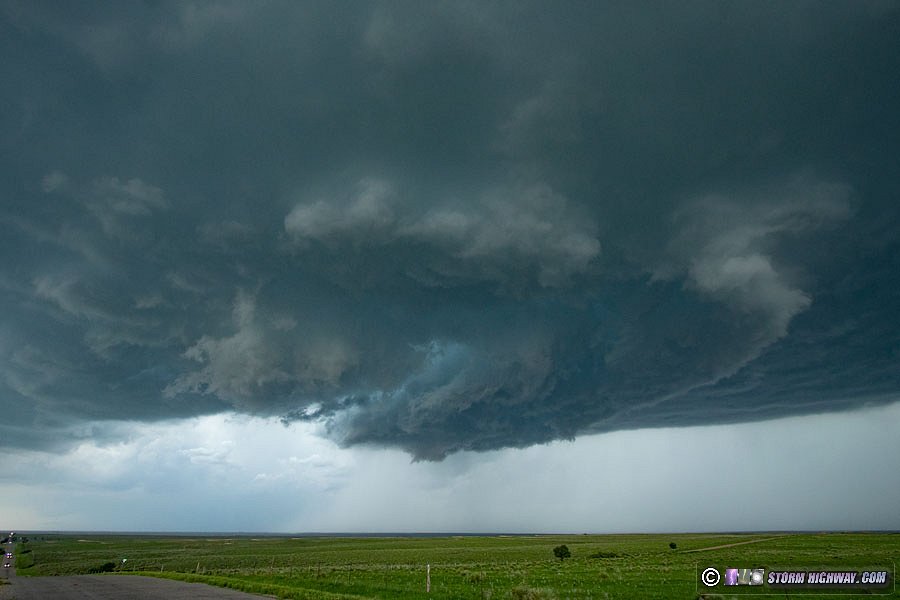
As we headed west from El Reno at 3PM, a new complication was happening: the lead supercell in southwestern Oklahoma had already developed hours ahead of when models indicated, and the cumulus field in the Texas panhandle looked anemic. The new storm had the potential to interact with a warm frontal boundary just to its south. After stopping in Sayre to re-evaluate the situation, the decision was made to intercept the storm to our south. We were out of position on the northwest side of it, but made it to the storm's updraft near Snyder.
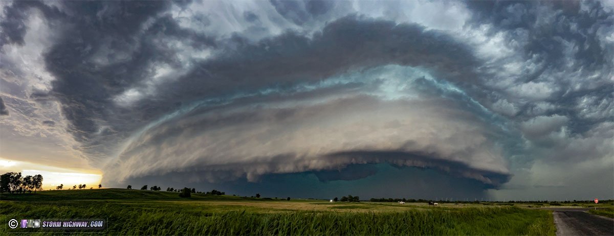
The storm was struggling after sending out a left split, and a lead cell had merged with it and itself developed a mesocyclone. These two mesos retained their identity, with neither one able to become dominant. As we moved east just behind the RFD gust front of the trailing meso to stay with it, the RFD suddenly kicked up new convection above it and we were quickly enveloped by heavy precip. The storm was also turning right much harder. We intended to make it to Lawton and drop south, but the surging RFD precip rapidly developed an intense VIL core that was going to cut off our southern route. With the main hail core to the north cutting off the east route and the RFD precip core blocking the southern route, I had no choice but to let the storm go and find some shelter from the wind-blown hail in Lawton (as I have not yet built my new hail shields). The largest stones I saw were a little greater than 2 inches.
Losing this storm was not as big of a concern, as the Red River was going to cut off being able to stay with it east of I-35 anyway. I turned my focus to a new dryline storm that had initiated to the west, intercepting it at Gould. This storm was never able to become established, and eventually the outflow from the original supercell moved westward into the new storm and terminated what little tornado potential it had.
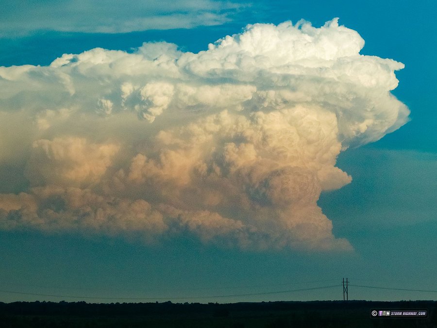
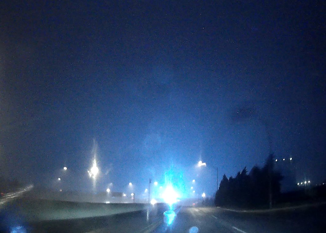
At this point, the tornado part of my day was done, and I switched focus to lightning - specifically getting to Oklahoma City ahead of the squall line moving in from the northwest to shoot upward flashes from the tower farm. As I drove east toward I-35, a supercell across the river in Texas to the south was putting on a dramatic show of explosive convection, including impressive knuckling and backsheared anvil. This ended up being the highlight of the day.

New storms were going up all over as I approached Oklahoma City, and a leading stratiform precip area was already producing upward flashes to the towers that I could see from a distance. I arrived at the towers just before the main squall line arrived. Unfortunately it did not have a trailing stratiform region, but it did produce one discharge that initiated a faint upward leader to one of the towers. Somehow this didn't save correctly on my high-speed camera, so the shot was lost.
Day 2, June 16: La Junta to Springfield, Colorado supercells
Friday's setup was somewhat marginal, and would require a 7-hour drive from Oklahoma City to southeastern Colorado to cover. Since I had expected Saturday's risk to be again west of Oklahoma City near I-40, I considered just taking a "down day" in OKC on Friday instead of driving so far for a 1-day risk. However, models began focusing Saturday's risk more into the Oklahoma panhandle region close to southeast Colorado, meaning that I would need to make most of that drive to near Saturday's target anyway. So, it made sense to just go ahead and cover Friday's event.
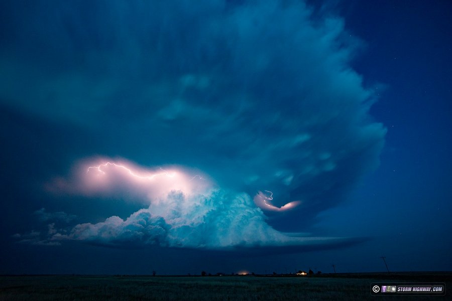
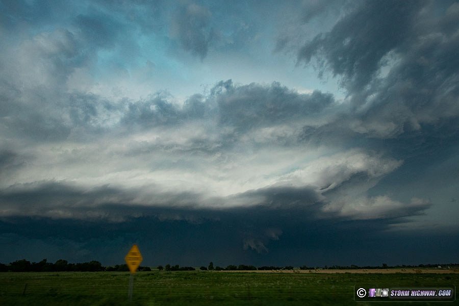
The setup in southeast Colorado was not great, with marginal low-level flow and only modest CAPE. However, veering-with-height wind profiles and decent upper support promised at least a couple of supercells that had a good chance of producing some quality lightning. I decided on the La Junta-Lamar corridor for what models indicated to be a tail-end cell that would be colocated with the better low-level shear. This storm developed as expected, and I headed toward an intercept southwest of La Junta. As I approached, it was producing a massive barrage of cloud-to-ground lightning that promised some great high-speed video, but this activity ceased once I arrived on the storm. The storm evolved into a supercell here and began turning hard to the right, making for a difficult time to stay with it.
Staying in position on this storm required being about 10-15 miles south of Highway 50, and since there were not other east-west roads, I had to go back up to Highway 50 then down the next north-south road to re-intercept.
While the storm was tornado-warned numerous times, it was very high-based and never displayed much in the way of visual signs of producing. The lightning was also disappointing, with the most spectacular discharges being once every 20-25 minutes and in completely random locations, mainly in the anvil region well east of the updraft. Eventually a squall line developed behind the storm and enveloped it just southwest of Lamar. A tail-end supercell was taking shape at the end of this line near Springfield. I had stopped west of Lamar to try catching one of the anvil bolts, and ended up staying to long to be able to beat the tornado-warned squall line circulations southward across Highway 385 and intercept the southern storm. I had to wait for these circulations to pass before heading south.
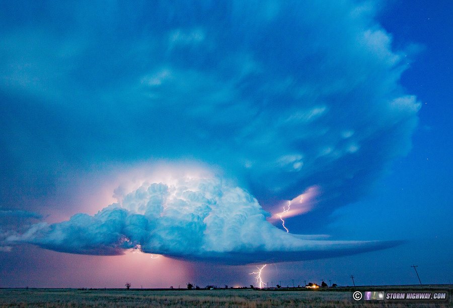
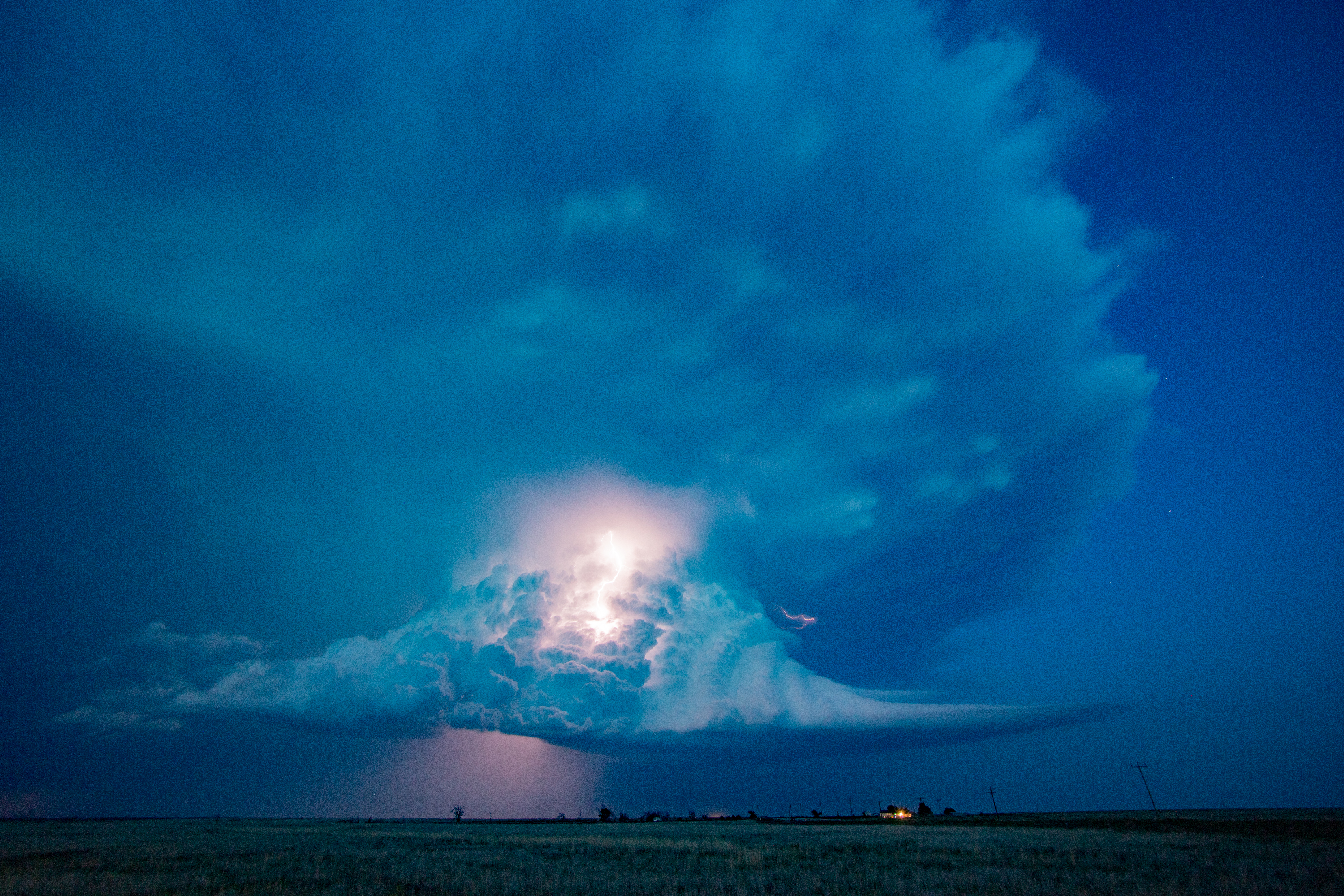
The southern supercell beat me into Springfield, and I had to hang back to wait for the hail core to pass. The lightning was OK, but the discharges were too small and it was now too dark for good high-speed shots. I ended up setting up south of Springfield facing east at the storm as it moved away. This ended up being a really nice scene for stills at "blue hour" with the front-lit cumulonibus, beaver inflow tail and large anvil periodically illuminated by lightning.
I headed to Guymon for the night to stage for Saturday's event, ending my day at 2AM.
Day 3, June 17: Balko, Oklahoma to Oklahoma City tornado, supercell and derecho
When I awoke in Guymon on Saturday morning and looked at data, I saw I was already in my general target area for the day. My target storms would not be firing until close to 4pm, so I had plenty of time to spend the whole morning in town writing for this blog, working on photos and getting breakfast and lunch at the Urban Bru cafe (which is now one of my favorite Great Plains coffee shops). After noon, I slowly began moving eastward to get just a little ahead of where I thought storms would fire (it's easier to go back west at a storm moving toward you than trying to catch one moving away). I stopped west of Balko to watch and wait, and a storm finally formed just to my west at 4:30pm. It was one of my better Plains forecast targets, as I didn't need to move at all for the first 20 minutes after the storm formed!
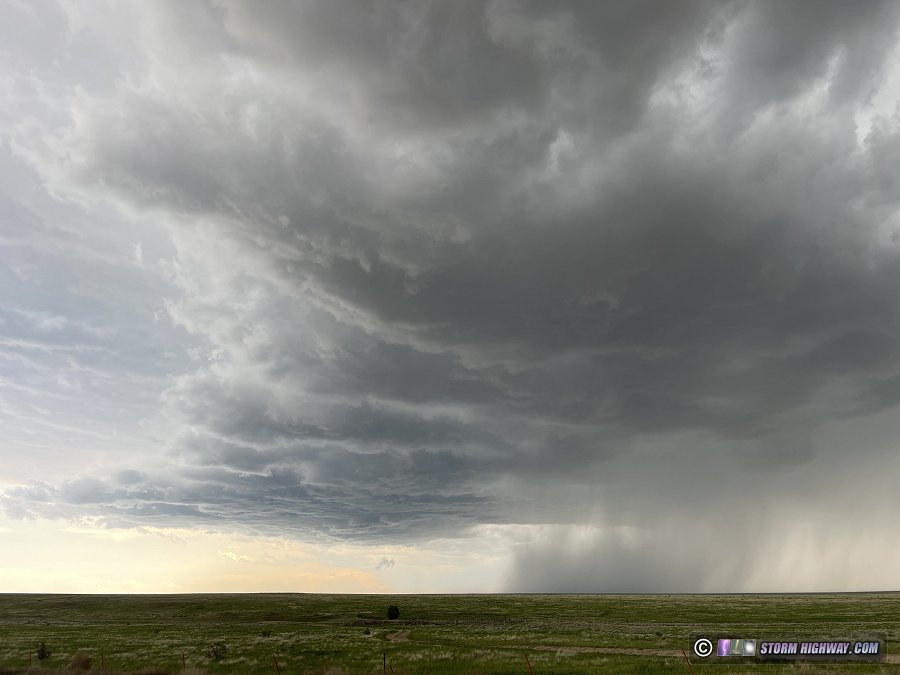
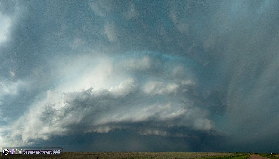
The storm was slowly lifting northeast, so I moved north a few miles to near Turpin where the storm began intensifying rapidly. A large RFD surge started carving into the base. There was a lot of dirt being lofted by the RFD, but after reading reports from other chasers, I can confirm that I did indeed witness a brief, weak tornado with this storm south of Turpin that I had first dismissed as straight-line RFD-lofted dirt.
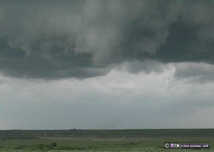
The clear slot remained well-defined with rapid rotation and occasional funnels.
There was a paved east-west road in perfect position for me to stay with the action area for the first 25 minutes or so, but this did not last. The paved road extended eastward, but the storm was slowly turning right and would soon overtake the road. I would need to be south of this latitude on the dirt road grid to stay with the storm. These roads were dry, but many of them did not have much gravel aggregate - which meant that just a 5-minute rain shower would render them impassable. Even graveled dirt roads in the Plains become treacherously slippery when wet, it's just like driving in snow and requires very slow speeds to avoid losing control and sliding into the ditch. Wet dirt roads, or dry dirt roads with the threat of rain, are both absolute no-gos for me. The RFD of the storm was producing flanking line convection southward that threatened to start raining on this road grid, so I decided to go south all the way to Highway 412 to get back to pavement. It was a risky move in terms of photography as it would take me far away from the storm, but it had to be done. Thankfully, the storm did not produce any tornadoes during this time I was so far away from it.
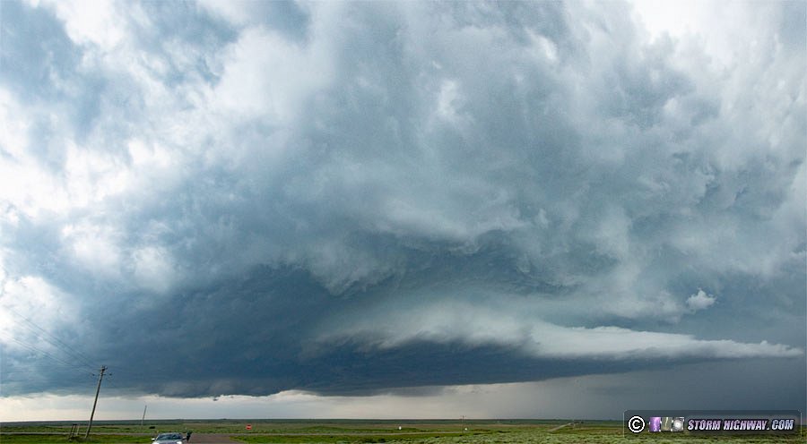
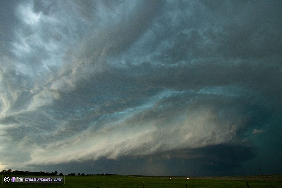
The big jump south to 412 became a non-issue anyway, as the storm was continuing to move slowly southeast closer to it. However, by now the storm was clearly becoming more linear, indicating the expected transition to a derecho was in progress. The storm's structure was also becoming very dramatic at this point, prompting several stops to shoot the scene both with stills and on high-speed video for the frequent vault region lightning.
|
Unfortunately the storm did not produce any spectacular lightning bolts while I was shooting with the high speed camera, and somehow my DSLR stills were slightly out of focus.
By now, chaser traffic on Highway 412 had picked up to the point that there was a fairly continuous flow of cars with intermittent breaks. Normally this would have not been a huge problem, but just as I left my last shooting stop on a side road west of Fort Supply, a pickup truck pulling a large trailer passed me, driving slowly. At the 412 intersection, he arrived at the stop sign - and just sat there. He was not willing to turn into any of the gaps in the traffic, and the derecho with 80+ mph winds was rapidly getting closer. We sat there for about 7 minutes, not moving, while countless gaps in the traffic that I could have easily entered passed us by. It was clear the pickup driver was not going to go until traffic was clear for a mile to the west, which was not going to happen any time soon. My map showed no other roads nearby to get east: I was trapped. As the derecho's precipitation arrived, I finally went around the truck to enter a gap in the traffic. This delay allowed the storm to overtake me as I passed through the slow-speed-limit-zone in Fort Supply. Thankfully, the storm was pushing more easterly than southerly, so I was able to make it back ahead of the precipitation core south of Woodward. I didn't get ahead of the storm's gust front until Watonga!
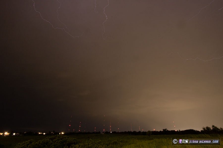
The goal now was to shoot upward lightning in Oklahoma City in the trailing stratiform region of the storms. I made it just in time - the derecho's leading edge was only 15 minutes behind me when I entered the city! When it did, the entire city was aglow with continuous power flashes. One of them was occurring just ahead of me on Highway 77 as lines touched in the strong winds.
I made it to a vantage point of the tower farm to begin shooting upward lightning, but there was no stratiform precip area behind the storm this far south. A small area of statiform precip did pass over in between some new storms firing behind the line, but no upward flashes occurred to the towers.
It was after 1AM when I finally decided the day was done, and I began heading east toward home. When I passed through Tulsa, more than three-quarters of the city was completely dark after being hit with an intense bowing section of the derecho. Winds here were reported to be between 90 to 100mph. I arrived at my overnight stop in Vinita just before 4AM.
Day 4, June 18: Springfield, Missouri to St. Louis thunderstorms (Trip #1 End)
Despite a dry slot with some clearing, models had really backed off any real potential for Sunday's storms under the core of the upper low in central Missouri. Nonetheless, any "spinny thing" in the Midwest is never something to ignore, so it would be a storm day on my last day on the road. The storms were uneventful until I arrived in the St. Louis metro area at mid-afternoon, when surprisingly lightning-active storms were rapidly developing. I stopped in Shrewsbury to shoot high speed video at the towers for 15 minutes, but no upward flashes occurred. I headed back east to view storms at the southern end of the arc of convection. There was no real structure, no circulations and lightning was meager, so I continued home to bring the trip to a close.
GO: Home | Storm Chase Logs | Photography | Extreme Weather Library | Stock Footage | Blog
Featured Weather Library Article:
|
|


