|
Home | Blog Index | Blog Archives | Christianity & Faith Essays | Storm Chasing Essays
Storm chasing season forecast update 10 for May 3
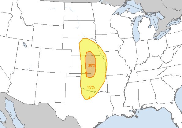
As we move to within 3 days of the big potential outbreak event on Monday the 6th, not a whole lot has changed from my last post. Models still show roughly the same large-scale upper level wind pattern and surface moisture/instability situation ahead of the dryline in the central and southern Plains. There has been a tendency for models to speed up the upper level jet's ejection. This means a risk of storms initiating on the dryline early in the day, even in the morning. This can greatly reduce the tornado risk with storms later, as it means the existing instability gets used up and the atmosphere is less likely to have time to recover for the main show later.

SPC's Day 4 outlook for Monday
That being said, the early timing is the only real potential negative I see in the pattern as it's currently shown now. As a storm chaser, there is never a meteorological reason to disregard (that is, stay home during) a system like this moving into the Plains in May (if you have moisture in place). Tim Marshall's "when it's May, you chase" is the guiding principle when you have even a tenth of what models show for Monday. Even if it ends up being a lower-end event due to early storms, it's likely to produce something of note somewhere, and we won't really know if it will bust until the day is almost over. Barring any complete collapse of model predictions or other unforeseen non-weather factors, this is a system that will almost certainly have me westbound Sunday night, Lord willing. Kansas seems the most likely place that the Monday's target ends up, but it could be a day where you can go anywhere from Texas to Nebraska and still see a tornado.
The days following Monday are still unclear. As models show now, there will be supercells and tornadoes somewhere from Dallas through the Great Lakes on Tuesday and Wednesday. The upper level jet overtop of abundant moisture is shown being widespread through the central USA during this time. Each day's target will be heavily influenced on how the previous day's storms evolve, mainly due to outflow boundaries and where those end up at storm time. This means there isn't even a general target evident for those days yet. There are some signs that Tuesday's target could be back here in St. Louis, but if the dryline can recover, southern Oklahoma or even Texas may be the better place. It's just too soon to say. Right now, all eyes are on Monday - I'll figure the following days out when things start to come into focus, and that might not happen until Monday night!
At this point, I'm at 95% confidence on trip 3 starting Sunday. The only reason I don't go higher is that it's the weather we're talking about - the bottom can and does sometimes drop out on these things, though I think the chances for that are slim at this point. I just know better than to declare a 100% more than 3 days out!
The following table charts the probabilities for a Plains storm chase expedition taking place for the date ranges shown:
| 2024 Plains Chase Expeditions - Probabilities as of May 3 |
| May 3-4 | 10% | |
| May 5-8 | 95% | |
| May 9-14 | 10% | |
|
| View 1,609 storm chases: |
| by year: |
|
| by type: |
|
|
|
GO: Home | Storm Chase Logs | Photography | Extreme Weather Library | Stock Footage | Blog
Featured Weather Library Article:
|