COOPERTON, OK - I witnessed four tornadoes within an HP supercell between Blair and Cooperton, Oklahoma on Friday, April 13. I was caught in the circulation of the last and largest tornado as it rapidly developed and moved over Highway 54 south of Cooperton. The following is a log of the day's chase. I woke up at 8:00AM on Friday at the Days Inn in Colby, Kansas expecting a long drive to southwestern Oklahoma. After getting packed up, filling up the gas tank and getting breakfast and coffee (Colby is one of only three places in western Kansas with a Starbucks), I was finally rolling south at 9:00AM.
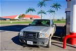 I had planned on a preliminary target of Shamrock, Texas, but expected to end up well south and west of there. Satellite, however, showed the dryline already even farther south and east than I expected. Consequently, I would no doubt miss early storms that went up and would have to decide which angle to play later. For the time being, I just had to cover the miles straight down Highway 83 to Shamrock, about a 6 hour drive. By the time I reached I-40 at Shamrock, storms were already in progress southwest of Oklahoma City. It appeared I might have a shot in catching the tail end storm still across the border in Texas, so moved east on I-40 to Sayre then down 283 toward Altus, then east on 19 at Blair. The tail end storm looked good on radar ,with a flying eagle and intense core. I would need to intercept in the Tipton/Manitou area. However, the storm slowly began a downward trend with each new radar scan. By the time I had traveled east on 19 by some distance, it had all but vanished. By now, the second of the two lead supercells was about 40 miles to my east, just north of Fort Sill. I briefly entertained trying to catch up to that storm, but new development to my southwest looked like a much better option. I hung around the Roosevelt area watching the easternmost of these storms develop, then quickly fizzle. It appeared an outflow boundary with cool, stable air on the north side was situated just south of this activity, keeping storms to its north from really taking off. The next storm to the southwest near Blair was the next play, so I headed back west on 19 toward it.
 When I reached it, it had dramatic structure but did not show much low-level organization:
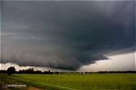 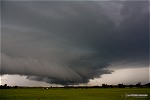 This storm also appeared to be suffering from being north of the outflow boundary, and never looked like it was going to develop surface-based inflow. The next storm to the southwest was closer to the outflow boundary, and I felt it had better potential to grab the convection-untouched instability-rich air to the south. I headed west on 19 to Blair and then south on 283 for a couple of miles to stop and chase the storm on a side road. The road I had turned off on was an 'ice mud' road, nearly impassable due to being saturated with rain from the previous storms. As a result I didn't venture past a railroad crossing, beyond which the road became even worse. A chaser had already become stuck just beyond the crossing.
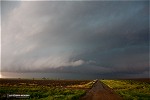 I began to correspond with Doug Kiesling to get the word out via social media that there was a storm chaser in distress (with a 2WD pickup, I was in no position to help!), but right then a 4WD vehicle arrived to help pull them out. The precip was beginning to catch up to me from the west, so I headed back north through Blair to 19 to head east. After I started east on 19, the storm suddenly intensified in a big way. Northerly winds began screaming across the road, picking up leaves, garbage cans and other small objects. It was a telltale sign that a tornado was likely developing to my south. It was incredible how fast this storm intensified. I raced east on 19 to get out of the precip. When I did, I could see that I was now in the notch of an intense HP supercell. A wall of dense heavy rain surrounded me in all directions except due east, with lowerings visible to the southwest.
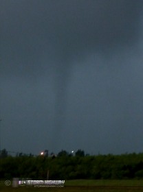
  An inflow band was racing southward as it curled into the meso just to my southwest. I could not see inside the rain, but the signs pointed to a large tornado likely in progress back in the rain to my southwest. Finally, a small tornado condensed to the ground to my south-southwest:
    I assume this was a satellite tornado alongside a larger one that I could not see in the rain. I slowly proceeded east on 19, stopping when two tornadoes touched down in succession just to the north of the road:
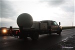
    At this point, Highway 19 takes a long northerly jog before turning east again, so I chose to hurry up and make that trek so I didn't get caught in large hail. During this time, the storm underwent a weakening trend. I made it to Cooperton and turned south on Highway 54 for a few miles to chase the storm. The storm's appearance looked similar to the earlier storm near Blair - dramatic structure, but with an undercut appearance. I pulled off onto a dirt road where a Texas Tech radar truck was parked about 1/2 mile west. The radar truck backed up to the highway, and there were some moments of confusion as I had to get out of their way multiple times while they turned around and positioned the radar to scan the storm. Finally, once we were all situated, I sat here for a few minutes watching the storm and pondering the next move.
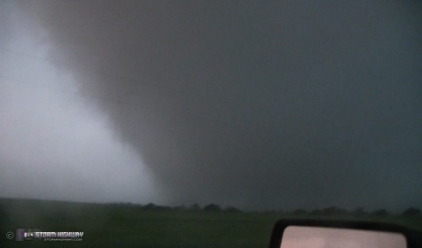
 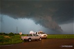 The storm looked as if it was suffering from being too far north of outflow from the previous storms. No radar-indicated circulations had been present for at least the past 20 minutes. It was starting to get dark, and with my next day's target expected to be in Nebraska, I wanted to get a jump on the drive by heading north to Oklahoma City to find a hotel. On ThreatNet, 2-inch hail markers were crossing the road to my north, so I pulled off onto a side road to let those pass before continuing north. When I turned back onto 54 northbound, I immediately noticed a tornado in progress to my northwest (timestamp on my dashcam is incorrect).
 I was in disbelief given how bad the storm had looked. With no traffic behind me, I stopped to watch and grab some video, assuming the tornado was eastbound and would cross the highway in front of me.
    However, not only did the tornado rapidly expand in size, I soon realized it was heading southeast right for me. I began backing up slowly, then faster once I realized the seriousness of the situation.
  While backing up, I nearly hit another chaser who had turned around in my path. I finally reached a side road to back into and turn around. Just as I did, the outer edge of the tornado caught up to me.
  I floored it southbound and managed to escape. My hands were shaking for 20 minutes afterward! The supercell continued to maintain a strong circulation for some time after this (with a likely tornado in progress that would have been within reach). However, I'd had enough for the day! I continued on my originally-planned drive northward, in disbelief about what had just happened. I ended up driving to Enid to share a hotel room with Justin Teague and Dave Crowley, who had driven there from Tulsa in preparation for the next day's big chase. On the way, I transferred all of the dashcam video (front and back) onto the laptop for safekeeping. After I returned home from this trip, I put together the dashcam video that shows the entire encounter: Click to watch. Footage from another chaser, Stephen Ostmo, shows the whole incident pretty well. They were farther south on Highway 54. I was down where the cluster of vehicle lights are at 5:28 in the video. You can see the car turn 90 degrees in the middle of the road. That is the vehicle I almost hit backing up trying to get away. At 7:03 in the video, you see me drive by after finally getting turned around: Click to watch When a large tornado starts catching you, it is not fun at all. It's not a position I'd ever put myself in on purpose, and I'm very blessed that this tornado wasn't stronger or moving faster. It really could have ended up being a very bad day. However, looking back on this event, and the fact that I made it out OK (not even a broken window), makes it one of my most memorable moments in storm chasing - if not *the* most memorable. What an experience! Other chaser accounts from this event:
NEXT EVENT: Amazing tornadoes during an outbreak in Kansas >>
|
|||||||||||||||
Web Site Design and Internet Marketing by CIS Internet


