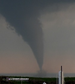
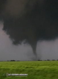
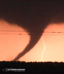
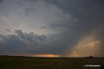
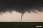
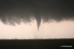
WAYNOKA, OK - This was my best storm chase day ever - multiple close, high-contrast photogenic tornadoes, intercepted in the Waynoka and Ingersoll areas of northwestern Oklahoma. The following is a log of the day's chase. I started the day in Enid, Oklahoma with good friends Dave Crowley and Justin Teague, who were planning on covering the southern portion of the dryline setup in northern Oklahoma. The day before, I had originally been leaning heavily toward the Nebraska target due to the better low-level wind profiles and vorticity closer to the surface low. I woke up on Saturday expecting to immediately start the long drive northward, but my mind was quickly changed by radar and satellite showing a very early-developing cluster of storms in Kansas. It appeared this activity would severely impact the instability for the northern target, so I chose to hold out with Dave and Justin for the Oklahoma dryline play. We slowly drifted westward out of Enid as storms began firing along the dryline far to the west. As some of these storms began to organize, one heading directly for Woodward became our first target storm of the day. We moved northwest on Highway 412 to watch the storm approach and pass over. The storm made several valiant attempts at organization, with a well developed wall cloud taking shape.
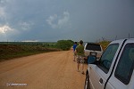 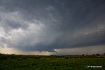 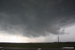 After the storm crossed 412, a funnel briefly became visible. With the storm racing off to the northeast, we were losing visual fast. With no promising downstream storms yet, we decided to attempt a second re-intercept on Highway 50 out of Mooreland. However, it became apparent that this would be a futile effort. Due to the storm's high rate of speed to the northeast, it would beat us across the road by at least 10 minutes. With new storms now getting organized to the southwest, at Mooreland, we elected to head north on Highway 50 and position for the next storm coming up the line. We chose to stay far ahead until the storm showed signs of organization due to its high forward speed. North of Freedom, we stopped to watch the situation evolve. With each radar scan, the storm to the south began slowing and turning to the right - slightly at first, then hard to the right toward Waynoka. We quickly headed to Highway 14 and dropped south to Waynoka then east a couple of miles on 281 to find a spot to view the storm as it approached. As the base of the storm came into view, a well-organized wall cloud with several intermittent funnels was in progress. This behavior continued on and off for the next 15 minutes as the storm got closer and closer, but it was never able to produce. The overall structure was impressive.
    By this time, another storm to the south was beginning to organize and increasingly seed the inflow of our storm with precip. Our storm's inflow remained strong, but its visual appearance was suffering. At this point, I began to fear that we were on track to bust on this high risk day. Eventually, our storm looked bad enough that we chose to drop down to the southern storm, which we knew was our last chance of the day. This cell had no other storms to the south of it to impede inflow. As we headed toward it, we received the first report of a tornado in progress. From the Highway 281/45 intersection, we went south about two miles on the dirt/gravel roads (thankfully still dry) and when we turned west to approach the storm's base, we could see a large tornado in progress.
  Trees and terrain kept us from viewing this tornado until we had traveled another mile or so to reach our first good viewing location. We got stopped as the tornado (#1) narrowed and planted condensation firmly to ground with a visible debris cloud:
    The tornado continued with debris visible as its condensation funnel lifted partly. At this time, a second area of circulation rapidly condensed downward to the ground for a second, simultaneous tornado (#2):
    The 'twins' continued for about a minute before both vanished. Just before dissipation, the first tornado struck an oil tank battery and ignited a fire, the smoke of which spread eastward:
  I had at first thought this was RFD-lofted dirt until reading later reports. The new meso was developing nearly overhead, so we jogged east and then north back toward Highway 281. As we did, a new tornado began spinning up (#3) with intermittent vorticies appearing on the ground. A skinny funnel appeared briefly:
  We drove across the tornado's path where tree limbs had been snapped. Thankfully, none blocked the road. When we reached Highway 281, traffic caused me to get separated from Justin and Dave. We did not get reunited again until the end of the day. I turned east on Highway 281, barely missing seeing the tornado (still #3) cross about 1/2 mile ahead where power poles had been snapped. Just beyond this, Highway 281 turns 90 degrees to the north, allowing me to approach the tornado's second crossing of the highway which would occur about a mile north of the turn. As I approached, the condensation funnel developed lower, with ground vorticies gradually developing toward it. The tornado crossed about 1/2 mile ahead of me:
    The tornado planted full condensation to the ground for a few seconds just as I pulled up alongside it. I stopped and got out in order to listen and record the sound of a tornado at close range. After I got out, the tornado's funnel had lifted slightly, but still put on a show with a cinnamon-swirl wall cloud and a debris fan on the ground:
    At this point, I had no paved road options to keep up with this tornado, so I decided to head north to Alva and turn east on 64 to punch through the hook and return to an ideal viewing location. My path would take me right through or very close to where large hail was likely to be, but I felt like cracking my windshield would be worth what I'd probably see on the other side (a windshield on my truck wasn't going to cost much anyway). As I began clearing the precip west of Ingersoll, not only did I avoid hail entirely, but a stout tornado (#4 of the day) was in progress to my southeast:
  I did not realize it at the time, but the previous tornado (#3, the one I'd just caught crossing the road on 281) was also visible behind me at the same time as the tornado up ahead, which was the second time that the storm was producing two simultaneous tornadoes. I never saw the end of tornado #3 behind me because I was too focused on #4. Had I learned of this in time, I might have been able to pull video from my rear camera of tornado #3's amazing drill-bit rope out behind me. It turns out that Justin and Dave were a couple miles behind me, filming tornado #3's incredible rope-out sequence at close range (see their video here). I wasn't too upset at missing the drill-bit rope scene, because I had my hands full with tornado #4. I knew I was going to easily reach its road crossing point up ahead and have a shot at yet another close-range encounter. The tornado took on several shapes under a small but classic wall cloud as it continued northeast, closer and closer to my path on Highway 64:
    Soon, my path and the tornado's path were about to cross. As this happened, the funnel once again lifted up, but still with a solid debris cloud on the ground. I slowed down slightly as the crossing point approached, since the town of Ingersoll was partially blocking my view. I did not want to drive straight into it.
   I cleared the town in time to watch the tornado cross about 1/4 mile ahead, ripping a small farm building to pieces with large chunks of roof and wood material flying.
    I pulled up alongside the scene with the tornado still doing damage to the farmstead.
   I stayed with this tornado for a good 15 minutes, watching the funnel periodically lift up and down, at times becoming fully condensed to the ground. Even when the funnel disappeared, the debris cloud on the ground remained continuous through the entire sequence. In other words, this was all one tornado (still #4). The wall cloud was impressive in itself, carouseling around at a rapid pace (a power flash is visible under the wall cloud in the 6th image below).
    Finally, this tornado either dissipated or moved off into the precip, as I lost visual on it to the north. I drove a short distance east of Ingersoll when a new tornado (#5) was visible developing to the north. This tornado became quite large, morphing into a wide cone before I lost it in the darkness. Lightning flashes would illuminate it periodically:
    As tornado #5 faded into the dark haze to the north, yet another tornado rapidly developed to the northeast (#6), the third time the storm produced two tornadoes at once. Despite the now-dark conditions, tornado #6 was visible in the lightning flashes:
    Tornado #6 also grew large, with a huge debris cloud:
    I never saw the end of tornado #6 - it continued going strong until it was too far away to see. The storm went on producing tornadoes for hours as it crossed into Kansas, including ones that affected the Wichita area. After tornado #6 exited stage right, my chase was over. I could have continued following the storm and saw more tornadoes, but the storm chaser numbers were increasing and I was many miles behind the storm. I got a call from Dave and Justin, who were a few miles to the north (close to where tornado #5 had been). We met up on Highway 64 north of Cherokee and caravanned back to Tulsa. I originally was planning to overnight in Tulsa, but could not get to sleep. As a result, I used the 'awake time' to cover a couple hundred miles of my trip back home. I finally stopped for a nap after sunrise at a rest area east of Springfield, MO, bringing this long but memorable storm chase day to a close. Other chaser accounts from this event:
|
||||||||||||||||||
Web Site Design and Internet Marketing by CIS Internet


