Washout: Charleston, WV - July 8, 2001 - 4:30 AM Washout: Charleston, WV - July 8, 2001 - 4:30 AM
Disaster often strikes without warning. If we could have seen what was coming, we would have planned accordingly - and lives and property would have been saved. But the biggest disaster coming in our lives is one that we have plenty of warning about. The good news is, we've been given a way to survive it. Whatever you do, just don't ignore the warnings. Soon it will be too late.
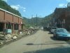
There was a lot of lightning early Sunday morning. And in West Virginia, a lot of lightning usually is accompanied by a lot of rain. July 8's storms set the stage for record flooding in most areas of southern West Virginia. Some counties saw up to 8 inches of rain in several hours, causing a large-scale disaster with miles of railroads and roads washed out or covered with landslides, thousands of homes and businesses damaged or destroyed, entire towns decimated and at least one person dead.
The first photo at right shows the intensity of the heavy rain, almost washing out a nearby lightning strike to a hillside less than 1/4 mile away, shot from my living room window near Greenbrier Street in Charleston.
The whole event was caused by a large MCC (Meso-Convective Complex, a large, long-lasting system of strong thunderstorms that persist for more than 6 hours) that developed in in eastern Ohio just after midnight and slowly tracked southeast through West Virginia, Virginia and North Carolina, reaching South Carolina by midday Sunday and finally dissipating soon afterwards (see radar loop below). The system was composed of numerous individual cells that kept 'training' over the same areas. The lightning and rain was almost constant in Charleston from 3:30am to 7:00am, with some 15 minute breaks here and there. More cells moved over later in the morning around 8:30am. In all, I counted eight separate thunderstorm cells moving over Charleston.
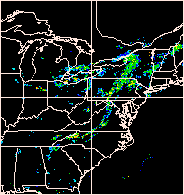 The NEXRAD Doppler Radar loop at right shows the all-night lifespan of the July 8, 2001 MCC as it develops in Ohio and moves across the Mountain State. The NEXRAD Doppler Radar loop at right shows the all-night lifespan of the July 8, 2001 MCC as it develops in Ohio and moves across the Mountain State.
Earlier in the evening, I had driven towards Parkersburg to try and get in front of the newly developing storms in Ohio. But the system began to rapidly progress into eastern West Virginia faster than anticipated (see radar image above). I began encountering new cells forming in southern Jackson County, which forced me to turn around and head back south to try and stay ahead of the activity. I got back in Charleston around 2:00am and set up the cameras beside the small hilltop overpass over I-79 near Big Chimney. But the rains arrived first, forcing me back on the road and eventually home to my living room window vantage point.
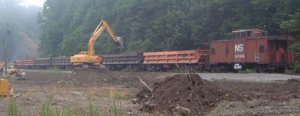
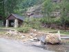
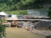
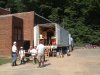
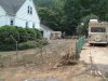
The American Baptist Men's Disaster Relief team arrived in Mullens on Thursday, July 12, where we assisted in the cleanup efforts. The destruction caused by flash flooding is unbelievable when you witness it firsthand (view photos at right).
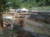
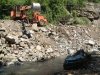
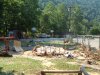
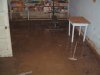
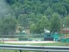
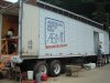
Later that month, Dunbar First Baptist Church sent a team to Wyoming county to assist in the cleanup efforts along the Guyandotte River (photos below). The damage was incredible; view more photos from our trip.
Camera/Lens/Film: 35mm Pentax K1000 SLR, 28mm lens, Fujichrome Sensia II 100 slide.
Exposure: 5 to 15 seconds @ F5.6/F8 |